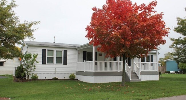
Property Record
6066 Old Beattie Rd, Lockport, NY 14094

NEARBY LISTINGS FOR SALE OR LEASE
-
-
View all Lockport listings for sale on LoopNet.com
Property Detail
6066 Old Beattie Rd
Buffalo-Cheektowaga, NY
Holland Land Companys Survey
292600-138-000-0001-013-111
WOODLANDS PHASE I - 285 U
Mobilehomepark
Niagara
X
New York
36063C0381E
12.000
2025
198.40 AC
2024
Outlying Niagara County
023901
Buffalo/Niagara Falls
DEMOGRAPHICS near 6066 Old Beattie Rd
1 Mile
3 Mile
5 Mile
2024 Total Population
4,595
20,128
47,526
2029 Population
4,601
20,005
46,992
Pop Growth 2024-2029
+ 0.13%
(0.61%)
(1.12%)
Average Age
42
42
42
2024 Total Households
2,133
8,727
20,401
HH Growth 2024-2029
+ 0.14%
(0.62%)
(1.15%)
Median Household Inc
$53,391
$69,408
$67,632
Avg Household Size
2.20
2.30
2.30
2024 Avg HH Vehicles
2.00
2.00
2.00
Median Home Value
$67,373
$165,386
$169,620
Median Year Built
1990
1978
1971
Nearby Places
Map Layers
Map Styles
 Street
 Aerial
- Restaurants
- Banks
- Shops
- Fitness
- Groceries
PUBLIC TRANSPORTATION
AIRPORT
Buffalo Niagara International
DRIVE
WALK
Distance
Buffalo Niagara International
24 min
14.8 mi
Niagara Falls International
DRIVE
WALK
Distance
Niagara Falls International
27 min
15.4 mi
Freight Ports
Albany, NY Port
DRIVE
WALK
Distance
Albany, NY Port
343 min
285.2 mi
Nearby Properties
Address
Land Use
TOTAL SIZE
Lot Size
Zoning
Address
Land Use
TOTAL SIZE
Lot Size
Zoning
Address
Land Use
TOTAL SIZE
Lot Size
Zoning
90,347 SF
18.67 AC
B-2
Address
Land Use
TOTAL SIZE
Lot Size
Zoning
65,184 SF
100.76 AC
B-2
Address
Land Use
TOTAL SIZE
Lot Size
Zoning
259,393 SF
33.74 AC
RA
Address
Land Use
TOTAL SIZE
Lot Size
Zoning
516 SF
53.70 AC
Address
Land Use
TOTAL SIZE
Lot Size
Zoning
90.60 AC
AR
Address
Land Use
TOTAL SIZE
Lot Size
Zoning
4,417 SF
61.30 AC
Address
Land Use
TOTAL SIZE
Lot Size
Zoning
206,149 SF
17.86 AC
B-2
Address
Land Use
TOTAL SIZE
Lot Size
Zoning
8,604 SF
15 AC
R-2
Address
Land Use
TOTAL SIZE
Lot Size
Zoning
13,828 SF
48.06 AC
I3
Address
Land Use
TOTAL SIZE
Lot Size
Zoning
111,617 SF
16.83 AC
RA
Address
Land Use
TOTAL SIZE
Lot Size
Zoning
130,160 SF
13 AC
B-2
Address
Land Use
TOTAL SIZE
Lot Size
Zoning
280 SF
31 AC
Address
Land Use
TOTAL SIZE
Lot Size
Zoning
130,946 SF
11.10 AC
B-2
Address
Land Use
TOTAL SIZE
Lot Size
Zoning
115,228 SF
10.90 AC
Address
Land Use
TOTAL SIZE
Lot Size
Zoning
Address
Land Use
TOTAL SIZE
Lot Size
Zoning
140,048 SF
13.60 AC
B-2
Address
Land Use
TOTAL SIZE
Lot Size
Zoning
792 SF
20.30 AC
Address
Land Use
TOTAL SIZE
Lot Size
Zoning
51,125 SF
12.20 AC
Address
Land Use
TOTAL SIZE
Lot Size
Zoning
7,692 SF
3.82 AC
R3
Address
Land Use
TOTAL SIZE
Lot Size
Zoning
27.12 AC
Address
Land Use
TOTAL SIZE
Lot Size
Zoning
23,904 SF
2 AC
Address
Land Use
TOTAL SIZE
Lot Size
Zoning
157,785 SF
7.32 AC
I3
Address
Land Use
TOTAL SIZE
Lot Size
Zoning
14,832 SF
1.64 AC
B2
Address
Land Use
TOTAL SIZE
Lot Size
Zoning
52,000 SF
30.40 AC
R-1
Address
Land Use
TOTAL SIZE
Lot Size
Zoning
81,875 SF
8.67 AC
RA
Address
Land Use
TOTAL SIZE
Lot Size
Zoning
67,960 SF
8.51 AC
B3
Address
Land Use
TOTAL SIZE
Lot Size
Zoning
66,581 SF
5.86 AC
B2
Address
Land Use
TOTAL SIZE
Lot Size
Zoning
56,476 SF
6.35 AC
B-2
The World's #1 Commercial Real Estate Marketplace
Connect with us
© 2026 CoStar Group
The information above has been obtained from sources believed reliable. While we do not doubt its accuracy we have not verified it and make no guarantee, warranty or representation about it. It is your responsibility to independently confirm its accuracy and completeness. Any projections, opinions, assumptions, or estimates used are for example only and do not represent the current or future performance of the property. The value of this transaction to you depends on tax and other factors which should be evaluated by your tax, financial, and legal advisors. You and your advisors should conduct a careful, independent investigation of the property to determine to your satisfaction the suitability of the property for your needs.