Property Record
60660 Us 31 S, South Bend, IN 46614
NEARBY LISTINGS FOR SALE OR LEASE
-
-
View all South Bend listings for lease on LoopNet.com
Property Detail
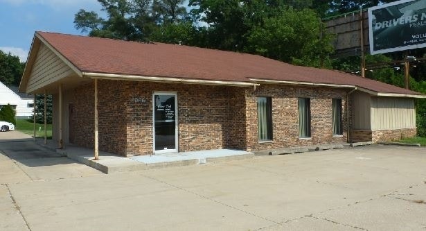
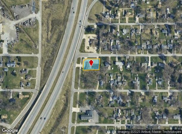
60660 Us 31 S
South Bend-Mishawaka, IN-MI
Gillmer Park
71-08-36-306-001.000-001
N 13.88 OF LOT 231 & ALL LOTS 232 & 233 GILLMER PARK EX PT TO STATE 19/20/ CONS W/ 001-1031-071601 PER OWNERS REQUEST
Medicalbuilding
St Joseph
X
Indiana
18141C0307D
231
2023
0.38 AC
2024
Outlying St Joseph County
011804
South Bend/Mishawaka
2,560 SF
DEMOGRAPHICS near 60660 Us 31 S
1 Mile
3 Mile
5 Mile
2024 Total Population
3,899
31,780
95,573
2029 Population
3,836
31,521
95,764
Pop Growth 2024-2029
(1.62%)
(0.81%)
+ 0.20%
Average Age
45
40
38
2024 Total Households
1,614
13,092
38,617
HH Growth 2024-2029
(1.67%)
(0.92%)
+ 0.13%
Median Household Inc
$82,301
$60,588
$49,873
Avg Household Size
2.40
2.30
2.40
2024 Avg HH Vehicles
2.00
2.00
2.00
Median Home Value
$206,842
$155,858
$127,943
Median Year Built
1975
1964
1956
Nearby Places
Map Layers
Map Styles
 Street
 Aerial
- Restaurants
- Banks
- Shops
- Fitness
- Groceries
PUBLIC TRANSPORTATION
AIRPORT
South Bend International
DRIVE
WALK
Distance
South Bend International
20 min
14.5 mi
SALE & LEASE HISTORY
LISTING DATE
SALE/LEASE

Sep 23, 2016
For Sale
Nov 01, 2016
For Lease
Nov 01, 2016
For Sale
Nearby Properties
Address
Land Use
TOTAL SIZE
Lot Size
Zoning
Address
Land Use
TOTAL SIZE
Lot Size
Zoning
270,484 SF
131 SF
Address
Land Use
TOTAL SIZE
Lot Size
Zoning
338,816 SF
33.65 AC
Address
Land Use
TOTAL SIZE
Lot Size
Zoning
283,481 SF
51.29 AC
Address
Land Use
TOTAL SIZE
Lot Size
Zoning
231,450 SF
87 SF
Address
Land Use
TOTAL SIZE
Lot Size
Zoning
25,228 SF
68.61 AC
Address
Land Use
TOTAL SIZE
Lot Size
Zoning
221,887 SF
87 SF
Address
Land Use
TOTAL SIZE
Lot Size
Zoning
174,526 SF
24.37 AC
Address
Land Use
TOTAL SIZE
Lot Size
Zoning
91,091 SF
131 SF
Address
Land Use
TOTAL SIZE
Lot Size
Zoning
136,568 SF
44 SF
Address
Land Use
TOTAL SIZE
Lot Size
Zoning
79,760 SF
13.17 AC
Address
Land Use
TOTAL SIZE
Lot Size
Zoning
79,911 SF
18.98 AC
Address
Land Use
TOTAL SIZE
Lot Size
Zoning
123,359 SF
44 SF
Address
Land Use
TOTAL SIZE
Lot Size
Zoning
87,310 SF
44 SF
Address
Land Use
TOTAL SIZE
Lot Size
Zoning
93,530 SF
8.08 AC
Address
Land Use
TOTAL SIZE
Lot Size
Zoning
15,436 SF
174 SF
Address
Land Use
TOTAL SIZE
Lot Size
Zoning
62,834 SF
87 SF
Address
Land Use
TOTAL SIZE
Lot Size
Zoning
158,495 SF
12.23 AC
Address
Land Use
TOTAL SIZE
Lot Size
Zoning
4,464 SF
131 SF
Address
Land Use
TOTAL SIZE
Lot Size
Zoning
52,648 SF
2.80 AC
Address
Land Use
TOTAL SIZE
Lot Size
Zoning
93,376 SF
23.93 AC
Address
Land Use
TOTAL SIZE
Lot Size
Zoning
48,204 SF
44 SF
Address
Land Use
TOTAL SIZE
Lot Size
Zoning
52,500 SF
32.50 AC
Address
Land Use
TOTAL SIZE
Lot Size
Zoning
1,418,289 SF
74.42 AC
Address
Land Use
TOTAL SIZE
Lot Size
Zoning
161,462 SF
18 AC
Address
Land Use
TOTAL SIZE
Lot Size
Zoning
322,768 SF
26.46 AC
Address
Land Use
TOTAL SIZE
Lot Size
Zoning
20,277 SF
8.95 AC
Address
Land Use
TOTAL SIZE
Lot Size
Zoning
63,969 SF
9.20 AC
Address
Land Use
TOTAL SIZE
Lot Size
Zoning
38,304 SF
24.41 AC
Address
Land Use
TOTAL SIZE
Lot Size
Zoning
35,702 SF
44.52 AC
Address
Land Use
TOTAL SIZE
Lot Size
Zoning
11,581 SF
0.01 AC
The World's #1 Commercial Real Estate Marketplace
Connect with us
© 2025 CoStar Group
The information above has been obtained from sources believed reliable. While we do not doubt its accuracy we have not verified it and make no guarantee, warranty or representation about it. It is your responsibility to independently confirm its accuracy and completeness. Any projections, opinions, assumptions, or estimates used are for example only and do not represent the current or future performance of the property. The value of this transaction to you depends on tax and other factors which should be evaluated by your tax, financial, and legal advisors. You and your advisors should conduct a careful, independent investigation of the property to determine to your satisfaction the suitability of the property for your needs.