Property Record
6067 Spring Ridge Pky, Frederick, MD 21701

Save to a Folder
{{folder.Name}}
{{folder.ListingIds.length}} Properties
{{folder.ListingIds.length}} Property
Create a New Folder
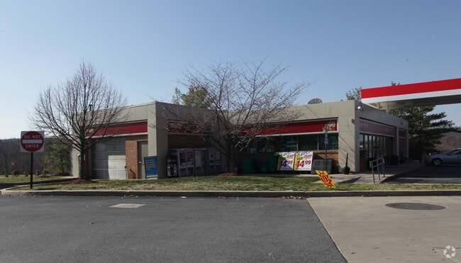
Property Detail
6067 Spring Ridge Pky
09-290907
LOT 7500 SEC C4 PL75 1.3348 ACRES SPRING RIDGE
Storebuilding
Frederick
PUD
Maryland
B and X Area of moderate flood hazard, usually the area between the limits of the 100-year and 500-year floods.
7500
2024
1.33 AC
2025
Frederick
751902
Washington, DC
2,076 SF
Washington-Arlington-Alexandria, DC-VA-MD-WV
NEARBY LISTINGS FOR SALE OR LEASE
-
-
View all Frederick listings for sale on LoopNet.com
DEMOGRAPHICS near 6067 Spring Ridge Pky
1 mile
3 mile
5 mile
2025 Total Population
7,162
27,111
115,066
2030 Population
7,737
29,862
125,210
Pop Growth 2025-2030
+ 8.03%
+ 10.15%
+ 8.82%
Average Age
39
38
39
2025 Total Households
2,559
9,354
42,945
HH Growth 2025-2030
+ 8.17%
+ 10.19%
+ 8.92%
Median Household Inc
$143,089
$147,381
$116,511
Avg Household Size
2.80
2.80
2.60
2025 Avg HH Vehicles
2.00
2.00
2.00
Median Home Value
$498,988
$563,574
$469,080
Median Year Built
1996
1998
1993
Nearby Places
Map Layers
Map Styles
 Street
 Aerial
Layers
 Traffic
 Biking
Places
Listings with unknown addresses are not visible on the map
- Restaurants
- Banks
- Shops
- Fitness
- Groceries
PUBLIC TRANSPORTATION
COMMUTER RAIL
Drive
Walk
Distance
8 min
4.1 mi
Drive
Walk
Distance
12 min
5.5 mi
AIRPORT
Hagerstown Regional/Richard A Henson Field
Drive
Walk
Distance
Hagerstown Regional/Richard A Henson Field
47 min
34.4 mi
Washington Dulles International
Drive
Walk
Distance
Washington Dulles International
72 min
46.3 mi
Freight Ports
Port of Baltimore
Drive
Walk
Distance
Port of Baltimore
57 min
45.4 mi
Nearby Properties
Address
Land Use
TOTAL SIZE
Lot Size
Zoning
Address
Land Use
TOTAL SIZE
Lot Size
Zoning
336,506 SF
31.96 AC
MXE
Address
Land Use
TOTAL SIZE
Lot Size
Zoning
167,328 SF
617.27 AC
IST
Address
Land Use
TOTAL SIZE
Lot Size
Zoning
348,171 SF
12.76 AC
PUD
Address
Land Use
TOTAL SIZE
Lot Size
Zoning
254,000 SF
48.13 AC
PUD
Address
Land Use
TOTAL SIZE
Lot Size
Zoning
689,832 SF
55.26 AC
M1
Address
Land Use
TOTAL SIZE
Lot Size
Zoning
209,465 SF
32.49 AC
A
Address
Land Use
TOTAL SIZE
Lot Size
Zoning
540,148 SF
70.22 AC
MXE
Address
Land Use
TOTAL SIZE
Lot Size
Zoning
4,735 SF
135 AC
A
Address
Land Use
TOTAL SIZE
Lot Size
Zoning
211,052 SF
7.37 AC
MXE
Address
Land Use
TOTAL SIZE
Lot Size
Zoning
143,747 SF
55.18 AC
R3
Address
Land Use
TOTAL SIZE
Lot Size
Zoning
154,854 SF
7.94 AC
MXE
Address
Land Use
TOTAL SIZE
Lot Size
Zoning
27.28 AC
PB
Address
Land Use
TOTAL SIZE
Lot Size
Zoning
176,960 SF
16.10 AC
MXE
Address
Land Use
TOTAL SIZE
Lot Size
Zoning
113,647 SF
15.33 AC
GC
Address
Land Use
TOTAL SIZE
Lot Size
Zoning
165,680 SF
15.14 AC
MXE
Address
Land Use
TOTAL SIZE
Lot Size
Zoning
49,235 SF
7 AC
M1
Address
Land Use
TOTAL SIZE
Lot Size
Zoning
94,096 SF
17.17 AC
GC
Address
Land Use
TOTAL SIZE
Lot Size
Zoning
72,065 SF
22 AC
PUD
Address
Land Use
TOTAL SIZE
Lot Size
Zoning
150,020 SF
7.45 AC
Address
Land Use
TOTAL SIZE
Lot Size
Zoning
47,281 SF
8.46 AC
GC
Address
Land Use
TOTAL SIZE
Lot Size
Zoning
54,216 SF
117 AC
A
Address
Land Use
TOTAL SIZE
Lot Size
Zoning
171,195 SF
12.12 AC
PUD
Address
Land Use
TOTAL SIZE
Lot Size
Zoning
123,034 SF
9.68 AC
GC
Address
Land Use
TOTAL SIZE
Lot Size
Zoning
113,238 SF
5.73 AC
M1
Address
Land Use
TOTAL SIZE
Lot Size
Zoning
50,784 SF
4.98 AC
PB
Address
Land Use
TOTAL SIZE
Lot Size
Zoning
48,188 SF
49.78 AC
IST
Address
Land Use
TOTAL SIZE
Lot Size
Zoning
114,500 SF
11.72 AC
GC
Address
Land Use
TOTAL SIZE
Lot Size
Zoning
22,190 SF
7.64 AC
DR
Address
Land Use
TOTAL SIZE
Lot Size
Zoning
84,100 SF
2.57 AC
GC
Address
Land Use
TOTAL SIZE
Lot Size
Zoning
138,400 SF
7.55 AC
M1
The World's #1 Commercial Real Estate Marketplace
Connect with us
© 2026 CoStar Group
The information above has been obtained from sources believed reliable. While we do not doubt its accuracy we have not verified it and make no guarantee, warranty or representation about it. It is your responsibility to independently confirm its accuracy and completeness. Any projections, opinions, assumptions, or estimates used are for example only and do not represent the current or future performance of the property. The value of this transaction to you depends on tax and other factors which should be evaluated by your tax, financial, and legal advisors. You and your advisors should conduct a careful, independent investigation of the property to determine to your satisfaction the suitability of the property for your needs.