Property Record
607 Carthage Ave, Cincinnati, OH 45215
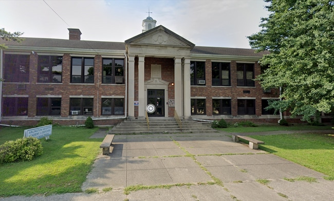

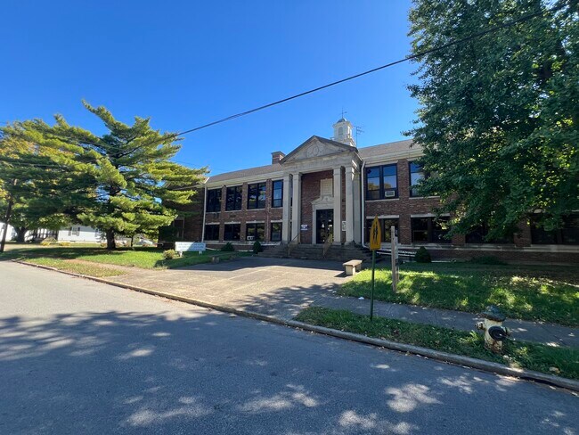
Property Detail
607 Carthage Ave
601-0002-0003-90
MAPLE ST FT IRR LOTS IN JOHN G OLDEN SUB PARS 3 THRU 7-26 THRU 30 CONS
Commercialnec
Hamilton
B and X Area of moderate flood hazard, usually the area between the limits of the 100-year and 500-year floods.
Ohio
2025
1.26 AC
2025
Woodlawn/Evendale
027400
Cincinnati/Dayton
14,908 SF
Cincinnati, OH-KY-IN
NEARBY LISTINGS FOR SALE OR LEASE
DEMOGRAPHICS near 607 Carthage Ave
1 mile
3 mile
5 mile
2025 Total Population
12,418
78,273
220,791
2030 Population
12,560
78,876
222,343
Pop Growth 2025-2030
+ 1.14%
+ 0.77%
+ 0.70%
Average Age
39
41
40
2025 Total Households
5,380
33,554
96,231
HH Growth 2025-2030
+ 1.12%
+ 0.84%
+ 0.71%
Median Household Inc
$50,481
$66,071
$68,647
Avg Household Size
2.20
2.20
2.20
2025 Avg HH Vehicles
2.00
2.00
2.00
Median Home Value
$152,354
$237,966
$245,714
Median Year Built
1948
1954
1955
Nearby Places
Map Layers
Map Styles
 Street
 Aerial
Layers
 Traffic
 Biking
Places
Listings with unknown addresses are not visible on the map
- Restaurants
- Banks
- Shops
- Fitness
- Groceries
PUBLIC TRANSPORTATION
AIRPORT
Cincinnati/Northern Kentucky International
Drive
Walk
Distance
Cincinnati/Northern Kentucky International
42 min
24.6 mi
Freight Ports
Port of Toledo
Drive
Walk
Distance
Port of Toledo
229 min
195.2 mi
SALE & LEASE HISTORY
LISTING DATE
SALE/LEASE

Jun 21, 2022
For Lease
Jun 21, 2022
For Sale
Nearby Properties
Address
Land Use
TOTAL SIZE
Lot Size
Zoning
Address
Land Use
TOTAL SIZE
Lot Size
Zoning
1,238 SF
14.03 AC
Address
Land Use
TOTAL SIZE
Lot Size
Zoning
29.67 AC
RM20
Address
Land Use
TOTAL SIZE
Lot Size
Zoning
11,639 SF
7.87 AC
R2
Address
Land Use
TOTAL SIZE
Lot Size
Zoning
23.45 AC
Address
Land Use
TOTAL SIZE
Lot Size
Zoning
15.61 AC
Address
Land Use
TOTAL SIZE
Lot Size
Zoning
4,599 SF
29.03 AC
R4
Address
Land Use
TOTAL SIZE
Lot Size
Zoning
8,964 SF
11.61 AC
Address
Land Use
TOTAL SIZE
Lot Size
Zoning
330,335 SF
0.80 AC
R3
Address
Land Use
TOTAL SIZE
Lot Size
Zoning
42.41 AC
Address
Land Use
TOTAL SIZE
Lot Size
Zoning
344,923 SF
18.47 AC
RM20
Address
Land Use
TOTAL SIZE
Lot Size
Zoning
Address
Land Use
TOTAL SIZE
Lot Size
Zoning
Address
Land Use
TOTAL SIZE
Lot Size
Zoning
2.22 AC
Address
Land Use
TOTAL SIZE
Lot Size
Zoning
4.64 AC
SF20
Address
Land Use
TOTAL SIZE
Lot Size
Zoning
Address
Land Use
TOTAL SIZE
Lot Size
Zoning
13,248 SF
24.99 AC
B
Address
Land Use
TOTAL SIZE
Lot Size
Zoning
Address
Land Use
TOTAL SIZE
Lot Size
Zoning
14.35 AC
Address
Land Use
TOTAL SIZE
Lot Size
Zoning
8,720 SF
33.28 AC
R3
Address
Land Use
TOTAL SIZE
Lot Size
Zoning
15.95 AC
C
Address
Land Use
TOTAL SIZE
Lot Size
Zoning
Address
Land Use
TOTAL SIZE
Lot Size
Zoning
23.41 AC
Address
Land Use
TOTAL SIZE
Lot Size
Zoning
31.98 AC
Address
Land Use
TOTAL SIZE
Lot Size
Zoning
13.43 AC
Address
Land Use
TOTAL SIZE
Lot Size
Zoning
9.74 AC
PD
Address
Land Use
TOTAL SIZE
Lot Size
Zoning
6.49 AC
Address
Land Use
TOTAL SIZE
Lot Size
Zoning
223,920 SF
9.55 AC
RM20
Address
Land Use
TOTAL SIZE
Lot Size
Zoning
10.36 AC
E
Address
Land Use
TOTAL SIZE
Lot Size
Zoning
Address
Land Use
TOTAL SIZE
Lot Size
Zoning
19.13 AC
The World's #1 Commercial Real Estate Marketplace
Connect with us
© 2026 CoStar Group
The information above has been obtained from sources believed reliable. While we do not doubt its accuracy we have not verified it and make no guarantee, warranty or representation about it. It is your responsibility to independently confirm its accuracy and completeness. Any projections, opinions, assumptions, or estimates used are for example only and do not represent the current or future performance of the property. The value of this transaction to you depends on tax and other factors which should be evaluated by your tax, financial, and legal advisors. You and your advisors should conduct a careful, independent investigation of the property to determine to your satisfaction the suitability of the property for your needs.