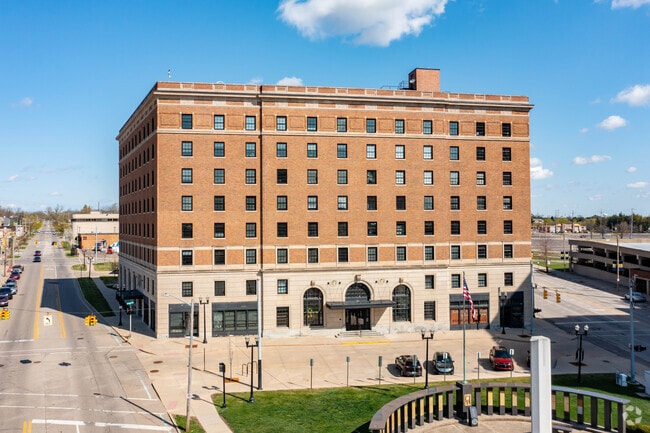
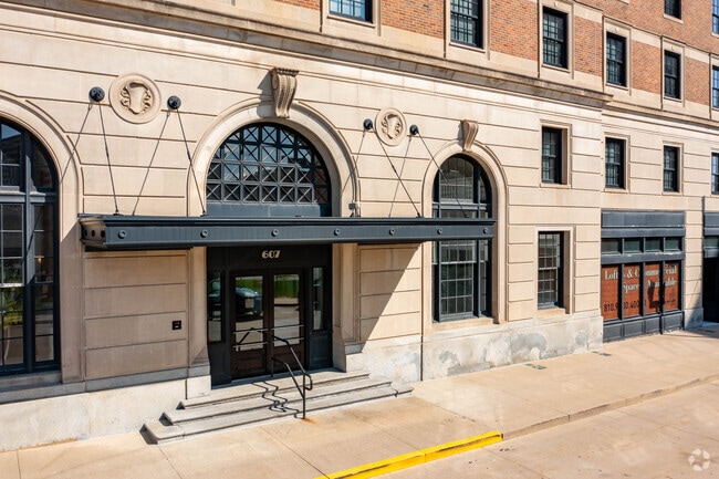
Property Record
607 E 2Nd Ave, Flint, MI 48502
Current Lease Availabilities
Property Detail
607 E 2Nd Ave
40-12-480-003
VILLAGE OF GRAND TRAVERSE LOTS 1, 2, 3 AND 10; ALSO LOT 9 AND A PART OF LOTS 7 & 8 DESC AS FOLLOWS: BEG ON THE W LINE OF
Commercialnec
Genesee
DE
Michigan
B and X Area of moderate flood hazard, usually the area between the limits of the 100-year and 500-year floods.
0.92 AC
2024
Carriage Town
2025
Detroit
002800
Flint, MI
203,200 SF
NEARBY LISTINGS FOR SALE OR LEASE
DEMOGRAPHICS near 607 E 2Nd Ave
1 mile
3 mile
5 mile
2024 Total Population
8,482
82,361
152,987
2029 Population
8,682
83,897
154,644
Pop Growth 2024-2029
+ 2.36%
+ 1.86%
+ 1.08%
Average Age
41
39
40
2024 Total Households
3,688
34,434
64,116
HH Growth 2024-2029
+ 2.52%
+ 1.86%
+ 1.03%
Median Household Inc
$27,960
$37,746
$41,340
Avg Household Size
1.80
2.20
2.30
2024 Avg HH Vehicles
1.00
1.00
1.00
Median Home Value
$73,081
$67,819
$84,523
Median Year Built
1953
1955
1958
Nearby Places
Map Layers
Map Styles
 Street
 Aerial
Transit
 Traffic
 Biking
Places
Listings with unknown addresses are not visible on the map
- Restaurants
- Banks
- Shops
- Fitness
- Groceries
PUBLIC TRANSPORTATION
COMMUTER RAIL
Drive
Walk
Distance
8 min
3.0 mi
AIRPORT
Bishop International
Drive
Walk
Distance
Bishop International
22 min
9.1 mi
Nearby Properties
Address
Land Use
TOTAL SIZE
Lot Size
Zoning
Address
Land Use
TOTAL SIZE
Lot Size
Zoning
381,509 SF
371.45 AC
PC
Address
Land Use
TOTAL SIZE
Lot Size
Zoning
290,267 SF
79 AC
PC
Address
Land Use
TOTAL SIZE
Lot Size
Zoning
54,651 SF
3.06 AC
Address
Land Use
TOTAL SIZE
Lot Size
Zoning
130,291 SF
Address
Land Use
TOTAL SIZE
Lot Size
Zoning
571,389 SF
584 AC
Address
Land Use
TOTAL SIZE
Lot Size
Zoning
112,232 SF
196 AC
Address
Land Use
TOTAL SIZE
Lot Size
Zoning
144,896 SF
0.23 AC
DC
Address
Land Use
TOTAL SIZE
Lot Size
Zoning
115,556 SF
2.50 AC
DE
Address
Land Use
TOTAL SIZE
Lot Size
Zoning
59,232 SF
3.65 AC
Address
Land Use
TOTAL SIZE
Lot Size
Zoning
329,849 SF
21.20 AC
CE
Address
Land Use
TOTAL SIZE
Lot Size
Zoning
247,555 SF
198 AC
Address
Land Use
TOTAL SIZE
Lot Size
Zoning
68,571 SF
0.81 AC
DC
Address
Land Use
TOTAL SIZE
Lot Size
Zoning
246,759 SF
19.03 AC
CC
Address
Land Use
TOTAL SIZE
Lot Size
Zoning
156,250 SF
Address
Land Use
TOTAL SIZE
Lot Size
Zoning
364,289 SF
24.80 AC
GN-1
Address
Land Use
TOTAL SIZE
Lot Size
Zoning
236,340 SF
25.17 AC
CE
Address
Land Use
TOTAL SIZE
Lot Size
Zoning
11.22 AC
RM
Address
Land Use
TOTAL SIZE
Lot Size
Zoning
290,502 SF
272.83 AC
Address
Land Use
TOTAL SIZE
Lot Size
Zoning
10,212 SF
2.60 AC
UC
Address
Land Use
TOTAL SIZE
Lot Size
Zoning
182,408 SF
Address
Land Use
TOTAL SIZE
Lot Size
Zoning
6,051 SF
3.82 AC
Address
Land Use
TOTAL SIZE
Lot Size
Zoning
85,697 SF
0.30 AC
DC
Address
Land Use
TOTAL SIZE
Lot Size
Zoning
209,058 SF
9.02 AC
Address
Land Use
TOTAL SIZE
Lot Size
Zoning
131,641 SF
136 AC
Address
Land Use
TOTAL SIZE
Lot Size
Zoning
403,803 SF
252 AC
Address
Land Use
TOTAL SIZE
Lot Size
Zoning
79,828 SF
6.48 AC
Address
Land Use
TOTAL SIZE
Lot Size
Zoning
123,170 SF
3.41 AC
DE
Address
Land Use
TOTAL SIZE
Lot Size
Zoning
Address
Land Use
TOTAL SIZE
Lot Size
Zoning
65,488 SF
0.30 AC
DC
The World's #1 Commercial Real Estate Marketplace
Connect with us
© 2026 CoStar Group
The information above has been obtained from sources believed reliable. While we do not doubt its accuracy we have not verified it and make no guarantee, warranty or representation about it. It is your responsibility to independently confirm its accuracy and completeness. Any projections, opinions, assumptions, or estimates used are for example only and do not represent the current or future performance of the property. The value of this transaction to you depends on tax and other factors which should be evaluated by your tax, financial, and legal advisors. You and your advisors should conduct a careful, independent investigation of the property to determine to your satisfaction the suitability of the property for your needs.