Property Record
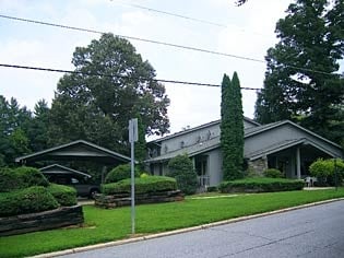
607 Hebron Rd, Hendersonville, NC 28739


Property Detail
607 Hebron Rd
1017053
HEBRON TERRACE
Apartment
Henderson
1017053~R-
North Carolina
B and X Area of moderate flood hazard, usually the area between the limits of the 100-year and 500-year floods.
775
2025
2 AC
2025
South End
931600
Asheville
4,778 SF
Asheville, NC
NEARBY LISTINGS FOR SALE OR LEASE
DEMOGRAPHICS near 607 Hebron Rd
1 mile
3 mile
5 mile
2025 Total Population
6,549
31,328
61,177
2030 Population
6,819
32,457
63,354
Pop Growth 2025-2030
+ 4.12%
+ 3.60%
+ 3.56%
Average Age
45
47
47
2025 Total Households
3,014
14,112
26,941
HH Growth 2025-2030
+ 4.35%
+ 3.72%
+ 3.69%
Median Household Inc
$54,227
$58,511
$61,183
Avg Household Size
2.10
2.10
2.20
2025 Avg HH Vehicles
2.00
2.00
2.00
Median Home Value
$347,393
$370,087
$381,388
Median Year Built
1970
1977
1984
Nearby Places
Map Layers
Map Styles
 Street
 Aerial
Layers
 Traffic
 Biking
Places
Listings with unknown addresses are not visible on the map
- Restaurants
- Banks
- Shops
- Fitness
- Groceries
PUBLIC TRANSPORTATION
AIRPORT
Asheville Regional
Drive
Walk
Distance
Asheville Regional
20 min
13.1 mi
Greenville Spartanburg International
Drive
Walk
Distance
Greenville Spartanburg International
62 min
39.8 mi
Nearby Properties
Address
Land Use
TOTAL SIZE
Lot Size
Zoning
Address
Land Use
TOTAL SIZE
Lot Size
Zoning
8,728 SF
8.84 AC
9970930~PC
Address
Land Use
TOTAL SIZE
Lot Size
Zoning
60,582 SF
9.54 AC
10010646~R
Address
Land Use
TOTAL SIZE
Lot Size
Zoning
60,582 SF
9.53 AC
9948805~R-
Address
Land Use
TOTAL SIZE
Lot Size
Zoning
96,084 SF
13.96 AC
1013416~PI
Address
Land Use
TOTAL SIZE
Lot Size
Zoning
97,776 SF
0.92 AC
1009121~MI
Address
Land Use
TOTAL SIZE
Lot Size
Zoning
29,233 SF
83.09 AC
10005104~O
Address
Land Use
TOTAL SIZE
Lot Size
Zoning
172,244 SF
18.87 AC
9968664~R-
Address
Land Use
TOTAL SIZE
Lot Size
Zoning
12,309 SF
6.52 AC
10005105~O
Address
Land Use
TOTAL SIZE
Lot Size
Zoning
105,179 SF
5.20 AC
1008855~PC
Address
Land Use
TOTAL SIZE
Lot Size
Zoning
44,485 SF
38.89 AC
9906409~OI
Address
Land Use
TOTAL SIZE
Lot Size
Zoning
70,136 SF
3.33 AC
10000154~O
Address
Land Use
TOTAL SIZE
Lot Size
Zoning
102,649 SF
7.08 AC
9904585~PI
Address
Land Use
TOTAL SIZE
Lot Size
Zoning
88,754 SF
4 AC
1003459~OI
Address
Land Use
TOTAL SIZE
Lot Size
Zoning
97,368 SF
6.66 AC
1000569~PI
Address
Land Use
TOTAL SIZE
Lot Size
Zoning
92,512 SF
3.38 AC
9968665~PR
Address
Land Use
TOTAL SIZE
Lot Size
Zoning
73,500 SF
16.40 AC
10010073~I
Address
Land Use
TOTAL SIZE
Lot Size
Zoning
51,166 SF
5.43 AC
9962201~R1
Address
Land Use
TOTAL SIZE
Lot Size
Zoning
40,975 SF
1.15 AC
9904361~C-
Address
Land Use
TOTAL SIZE
Lot Size
Zoning
72,560 SF
7.23 AC
10000067~P
Address
Land Use
TOTAL SIZE
Lot Size
Zoning
59,072 SF
6.62 AC
10008042~R
Address
Land Use
TOTAL SIZE
Lot Size
Zoning
68,080 SF
2.30 AC
1001184~PC
Address
Land Use
TOTAL SIZE
Lot Size
Zoning
690,212 SF
105.90 AC
1010645~I-
Address
Land Use
TOTAL SIZE
Lot Size
Zoning
33,419 SF
1.56 AC
10005796~R
Address
Land Use
TOTAL SIZE
Lot Size
Zoning
9,947 SF
1.67 AC
9948806~C-
Address
Land Use
TOTAL SIZE
Lot Size
Zoning
142,987 SF
12.13 AC
9968008~PC
Address
Land Use
TOTAL SIZE
Lot Size
Zoning
79,651 SF
10.24 AC
9928981~C-
Address
Land Use
TOTAL SIZE
Lot Size
Zoning
4,166 SF
9.42 AC
106319~C-3
Address
Land Use
TOTAL SIZE
Lot Size
Zoning
50,573 SF
6.71 AC
10003742~P
Address
Land Use
TOTAL SIZE
Lot Size
Zoning
65,839 SF
3.19 AC
1008569~CM
Address
Land Use
TOTAL SIZE
Lot Size
Zoning
51,624 SF
3.77 AC
9949557~CM
The World's #1 Commercial Real Estate Marketplace
Connect with us
© 2026 CoStar Group
The information above has been obtained from sources believed reliable. While we do not doubt its accuracy we have not verified it and make no guarantee, warranty or representation about it. It is your responsibility to independently confirm its accuracy and completeness. Any projections, opinions, assumptions, or estimates used are for example only and do not represent the current or future performance of the property. The value of this transaction to you depends on tax and other factors which should be evaluated by your tax, financial, and legal advisors. You and your advisors should conduct a careful, independent investigation of the property to determine to your satisfaction the suitability of the property for your needs.