Property Record
Highway 547 N, Davenport, FL 33837
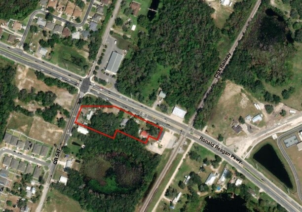
This Property Is For Sale
NEARBY LISTINGS FOR SALE OR LEASE
Property Detail
Highway 547 N
Lakeland-Winter Haven, FL
Alameda Heights
27-26-12-000000-032280
BEG 236.70 FT W OF NE COR OF SE1/4 OF NW1/4 RUN S 23 DEG 12 MIN W 113.4 FT TO POB RUN S 66 DEG 48 MIN E 142.55 FT S 23 DEG 12 MIN W 57.4 FT N 66 DEG 48 MIN W 142.55 FT N 23 DEG 12 MIN E 57.4 FT TO POB LESS THAT PART LYING WITHIN THE FOLL DESC PROPERT
Residentialacreage
Polk
X
Florida
12105C0230H
0.18 AC
2024
Polk County
2025
Tampa/St Petersburg
012508
DEMOGRAPHICS near Highway 547 N
1 Mile
3 Mile
5 Mile
2024 Total Population
6,470
31,965
69,972
2029 Population
8,015
39,986
87,199
Pop Growth 2024-2029
+ 23.88%
+ 25.09%
+ 24.62%
Average Age
36
37
39
2024 Total Households
2,152
11,220
25,731
HH Growth 2024-2029
+ 23.75%
+ 25.06%
+ 24.67%
Median Household Inc
$67,084
$59,791
$67,208
Avg Household Size
2.90
2.80
2.70
2024 Avg HH Vehicles
2.00
2.00
2.00
Median Home Value
$268,970
$283,199
$280,391
Median Year Built
2005
2006
2007
Nearby Places
Map Layers
Map Styles
 Street
 Aerial
- Restaurants
- Banks
- Shops
- Fitness
- Groceries
PUBLIC TRANSPORTATION
COMMUTER RAIL
Poinciana (SunRail - Florida Department of Transportation)
DRIVE
WALK
Distance
Poinciana (SunRail - Florida Department of Transportation)
9 min
6.3 mi
AIRPORT
Orlando International
DRIVE
WALK
Distance
Orlando International
42 min
30.3 mi
Freight Ports
Port of Tampa Bay
DRIVE
WALK
Distance
Port of Tampa Bay
78 min
64.1 mi
Nearby Properties
Address
Land Use
TOTAL SIZE
Lot Size
Zoning
Address
Land Use
TOTAL SIZE
Lot Size
Zoning
417,544 SF
62.60 AC
Address
Land Use
TOTAL SIZE
Lot Size
Zoning
434,491 SF
27.48 AC
Address
Land Use
TOTAL SIZE
Lot Size
Zoning
425,752 SF
19.52 AC
Address
Land Use
TOTAL SIZE
Lot Size
Zoning
436,302 SF
27.87 AC
Address
Land Use
TOTAL SIZE
Lot Size
Zoning
302,226 SF
135.83 AC
Address
Land Use
TOTAL SIZE
Lot Size
Zoning
335,536 SF
11.97 AC
Address
Land Use
TOTAL SIZE
Lot Size
Zoning
329,700 SF
12.09 AC
Address
Land Use
TOTAL SIZE
Lot Size
Zoning
352,892 SF
19.23 AC
Address
Land Use
TOTAL SIZE
Lot Size
Zoning
336,042 SF
20.77 AC
Address
Land Use
TOTAL SIZE
Lot Size
Zoning
216,296 SF
16.37 AC
Address
Land Use
TOTAL SIZE
Lot Size
Zoning
338,315 SF
59.58 AC
Address
Land Use
TOTAL SIZE
Lot Size
Zoning
164,106 SF
7.13 AC
Address
Land Use
TOTAL SIZE
Lot Size
Zoning
41,812 SF
162.70 AC
OAC
Address
Land Use
TOTAL SIZE
Lot Size
Zoning
148,436 SF
10.27 AC
Address
Land Use
TOTAL SIZE
Lot Size
Zoning
87,848 SF
14.44 AC
OAC
Address
Land Use
TOTAL SIZE
Lot Size
Zoning
98,712 SF
11.90 AC
Address
Land Use
TOTAL SIZE
Lot Size
Zoning
74,571 SF
9.98 AC
Address
Land Use
TOTAL SIZE
Lot Size
Zoning
22,458 SF
45.23 AC
OAC
Address
Land Use
TOTAL SIZE
Lot Size
Zoning
23,487 SF
2.54 AC
OPD
Address
Land Use
TOTAL SIZE
Lot Size
Zoning
88,912 SF
24.99 AC
RC
Address
Land Use
TOTAL SIZE
Lot Size
Zoning
28.18 AC
Address
Land Use
TOTAL SIZE
Lot Size
Zoning
11,688 SF
19.56 AC
OPD
Address
Land Use
TOTAL SIZE
Lot Size
Zoning
66,475 SF
6.26 AC
Address
Land Use
TOTAL SIZE
Lot Size
Zoning
112.98 AC
OPUD
Address
Land Use
TOTAL SIZE
Lot Size
Zoning
43,567 SF
29.99 AC
OPUD
Address
Land Use
TOTAL SIZE
Lot Size
Zoning
7,920 SF
2.14 AC
OPD
Address
Land Use
TOTAL SIZE
Lot Size
Zoning
13,786 SF
4.99 AC
Address
Land Use
TOTAL SIZE
Lot Size
Zoning
Address
Land Use
TOTAL SIZE
Lot Size
Zoning
6,899 SF
1.91 AC
OPD
Address
Land Use
TOTAL SIZE
Lot Size
Zoning
14,908 SF
1.45 AC
OPD
The World's #1 Commercial Real Estate Marketplace
Connect with us
© 2026 CoStar Group
The information above has been obtained from sources believed reliable. While we do not doubt its accuracy we have not verified it and make no guarantee, warranty or representation about it. It is your responsibility to independently confirm its accuracy and completeness. Any projections, opinions, assumptions, or estimates used are for example only and do not represent the current or future performance of the property. The value of this transaction to you depends on tax and other factors which should be evaluated by your tax, financial, and legal advisors. You and your advisors should conduct a careful, independent investigation of the property to determine to your satisfaction the suitability of the property for your needs.