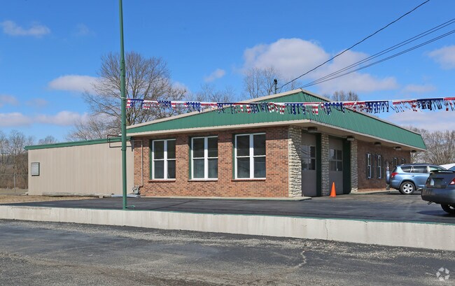
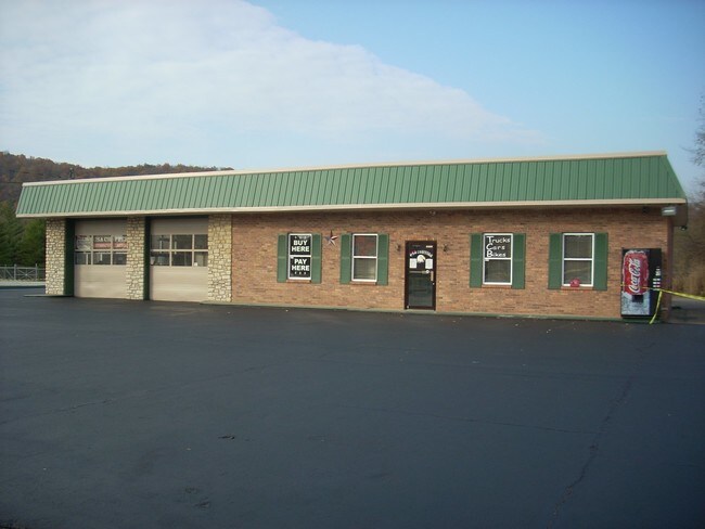
Property Record
607 S State St, West Harrison, IN 47060

NEARBY LISTINGS FOR SALE OR LEASE
Property Detail
607 S State St
15-01-24-104-029.000-007
E2s24t67nr1w
Autorepair
02-103 PT NW 24-7-1 .628A
X
Dearborn
18029C0064C
Indiana
2024
0.63 AC
2024
Dearborn County
080204
Cincinnati/Dayton
3,496 SF
Cincinnati, OH-KY-IN
DEMOGRAPHICS near 607 S State St
1 Mile
3 Mile
5 Mile
2024 Total Population
3,968
15,918
30,213
2029 Population
3,924
15,793
30,206
Pop Growth 2024-2029
(1.11%)
(0.79%)
(0.02%)
Average Age
39
41
41
2024 Total Households
1,649
6,340
11,626
HH Growth 2024-2029
(1.09%)
(0.88%)
(0.20%)
Median Household Inc
$61,901
$76,570
$86,294
Avg Household Size
2.40
2.50
2.60
2024 Avg HH Vehicles
2.00
2.00
2.00
Median Home Value
$150,596
$185,363
$224,468
Median Year Built
1965
1985
1989
Nearby Places
Map Layers
Map Styles
 Street
 Aerial
- Restaurants
- Banks
- Shops
- Fitness
- Groceries
PUBLIC TRANSPORTATION
AIRPORT
Cincinnati/Northern Kentucky International
DRIVE
WALK
Distance
Cincinnati/Northern Kentucky International
46 min
30.9 mi
Freight Ports
Port of Toledo
DRIVE
WALK
Distance
Port of Toledo
251 min
214.9 mi
SALE & LEASE HISTORY
LISTING DATE
SALE/LEASE

Mar 07, 2019
For Lease
Nearby Properties
Address
Land Use
TOTAL SIZE
Lot Size
Zoning
Address
Land Use
TOTAL SIZE
Lot Size
Zoning
102.29 AC
Address
Land Use
TOTAL SIZE
Lot Size
Zoning
35.80 AC
Address
Land Use
TOTAL SIZE
Lot Size
Zoning
2,040 SF
27.24 AC
Address
Land Use
TOTAL SIZE
Lot Size
Zoning
85,849 SF
14.25 AC
Address
Land Use
TOTAL SIZE
Lot Size
Zoning
22.19 AC
Address
Land Use
TOTAL SIZE
Lot Size
Zoning
21,686 SF
20 AC
Address
Land Use
TOTAL SIZE
Lot Size
Zoning
8.43 AC
Address
Land Use
TOTAL SIZE
Lot Size
Zoning
Address
Land Use
TOTAL SIZE
Lot Size
Zoning
27,234 SF
12.68 AC
Address
Land Use
TOTAL SIZE
Lot Size
Zoning
10.33 AC
FPUDSPI
Address
Land Use
TOTAL SIZE
Lot Size
Zoning
19.13 AC
Address
Land Use
TOTAL SIZE
Lot Size
Zoning
61.50 AC
H
Address
Land Use
TOTAL SIZE
Lot Size
Zoning
11.90 AC
Address
Land Use
TOTAL SIZE
Lot Size
Zoning
7.86 AC
Address
Land Use
TOTAL SIZE
Lot Size
Zoning
12.34 AC
Address
Land Use
TOTAL SIZE
Lot Size
Zoning
Address
Land Use
TOTAL SIZE
Lot Size
Zoning
10.49 AC
FPUDSPI
Address
Land Use
TOTAL SIZE
Lot Size
Zoning
Address
Land Use
TOTAL SIZE
Lot Size
Zoning
5,320 SF
26.52 AC
Address
Land Use
TOTAL SIZE
Lot Size
Zoning
27,586 SF
8 AC
Address
Land Use
TOTAL SIZE
Lot Size
Zoning
49,011 SF
11.22 AC
H
Address
Land Use
TOTAL SIZE
Lot Size
Zoning
19.28 AC
Address
Land Use
TOTAL SIZE
Lot Size
Zoning
43,445 SF
6 AC
Address
Land Use
TOTAL SIZE
Lot Size
Zoning
14.95 AC
Address
Land Use
TOTAL SIZE
Lot Size
Zoning
7.48 AC
Address
Land Use
TOTAL SIZE
Lot Size
Zoning
12,120 SF
7.47 AC
Address
Land Use
TOTAL SIZE
Lot Size
Zoning
Address
Land Use
TOTAL SIZE
Lot Size
Zoning
25.54 AC
A
Address
Land Use
TOTAL SIZE
Lot Size
Zoning
5.19 AC
FPUDSPI
Address
Land Use
TOTAL SIZE
Lot Size
Zoning
5.32 AC
D
The World's #1 Commercial Real Estate Marketplace
Connect with us
© 2025 CoStar Group
The information above has been obtained from sources believed reliable. While we do not doubt its accuracy we have not verified it and make no guarantee, warranty or representation about it. It is your responsibility to independently confirm its accuracy and completeness. Any projections, opinions, assumptions, or estimates used are for example only and do not represent the current or future performance of the property. The value of this transaction to you depends on tax and other factors which should be evaluated by your tax, financial, and legal advisors. You and your advisors should conduct a careful, independent investigation of the property to determine to your satisfaction the suitability of the property for your needs.