No Photo
Property Record
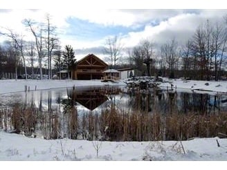
6070 Blue Star Hwy, Saugatuck, MI 49453

NEARBY LISTINGS FOR SALE OR LEASE
Property Detail
6070 Blue Star Hwy
11-036-006-00
THAT PART OF THE E 1/2 OF THE W 1/2 OF THE NE 1/4 DESC AS: COM AT NE COR OF SEC TH S 582.38' TH S 66 DEG 04'47 W 1943.19' ALG
Commercialnec
Allegan
X
Michigan
26005C0160G
7.86 AC
2024
Outlying Allegan County
2025
West Michigan
032402
Holland, MI
2,152 SF
DEMOGRAPHICS near 6070 Blue Star Hwy
1 Mile
3 Mile
5 Mile
2024 Total Population
406
4,315
13,498
2029 Population
415
4,440
13,922
Pop Growth 2024-2029
+ 2.22%
+ 2.90%
+ 3.14%
Average Age
44
44
45
2024 Total Households
160
1,736
5,503
HH Growth 2024-2029
+ 2.50%
+ 3.00%
+ 3.22%
Median Household Inc
$98,025
$89,636
$79,975
Avg Household Size
2.50
2.50
2.40
2024 Avg HH Vehicles
2.00
2.00
2.00
Median Home Value
$325,926
$325,441
$320,829
Median Year Built
1978
1985
1988
Nearby Places
Map Layers
Map Styles
 Street
 Aerial
- Restaurants
- Banks
- Shops
- Fitness
- Groceries
PUBLIC TRANSPORTATION
COMMUTER RAIL
Holland Amtrak Station (Pere Marquette - Amtrak)
DRIVE
WALK
Distance
Holland Amtrak Station (Pere Marquette - Amtrak)
17 min
8.7 mi
Freight Ports
Port Milwaukee
DRIVE
WALK
Distance
Port Milwaukee
269 min
228.9 mi
Nearby Properties
Address
Land Use
TOTAL SIZE
Lot Size
Zoning
Address
Land Use
TOTAL SIZE
Lot Size
Zoning
167,712 SF
6.71 AC
Address
Land Use
TOTAL SIZE
Lot Size
Zoning
70,428 SF
5.75 AC
Address
Land Use
TOTAL SIZE
Lot Size
Zoning
12,165 SF
10.40 AC
Address
Land Use
TOTAL SIZE
Lot Size
Zoning
17.63 AC
Address
Land Use
TOTAL SIZE
Lot Size
Zoning
9,107 SF
19.69 AC
R-2
Address
Land Use
TOTAL SIZE
Lot Size
Zoning
34.70 AC
Address
Land Use
TOTAL SIZE
Lot Size
Zoning
69,850 SF
19.23 AC
Address
Land Use
TOTAL SIZE
Lot Size
Zoning
50,400 SF
7.61 AC
Address
Land Use
TOTAL SIZE
Lot Size
Zoning
20,707 SF
3.22 AC
Address
Land Use
TOTAL SIZE
Lot Size
Zoning
1,912 SF
111.23 AC
Address
Land Use
TOTAL SIZE
Lot Size
Zoning
1,720 SF
58.44 AC
Address
Land Use
TOTAL SIZE
Lot Size
Zoning
67,768 SF
3.06 AC
Address
Land Use
TOTAL SIZE
Lot Size
Zoning
8,140 SF
4.82 AC
Address
Land Use
TOTAL SIZE
Lot Size
Zoning
43.14 AC
Address
Land Use
TOTAL SIZE
Lot Size
Zoning
4,000 SF
33.40 AC
Address
Land Use
TOTAL SIZE
Lot Size
Zoning
3,913 SF
2.43 AC
C-3
Address
Land Use
TOTAL SIZE
Lot Size
Zoning
384 SF
113.70 AC
Address
Land Use
TOTAL SIZE
Lot Size
Zoning
20,226 SF
2.50 AC
Address
Land Use
TOTAL SIZE
Lot Size
Zoning
10.34 AC
Address
Land Use
TOTAL SIZE
Lot Size
Zoning
14,719 SF
3.48 AC
Address
Land Use
TOTAL SIZE
Lot Size
Zoning
1,500 SF
117.38 AC
Address
Land Use
TOTAL SIZE
Lot Size
Zoning
70.58 AC
Address
Land Use
TOTAL SIZE
Lot Size
Zoning
13,424 SF
2.09 AC
Address
Land Use
TOTAL SIZE
Lot Size
Zoning
23,400 SF
9.11 AC
Address
Land Use
TOTAL SIZE
Lot Size
Zoning
61.80 AC
Address
Land Use
TOTAL SIZE
Lot Size
Zoning
2,960 SF
37.96 AC
Address
Land Use
TOTAL SIZE
Lot Size
Zoning
47,040 SF
3.43 AC
Address
Land Use
TOTAL SIZE
Lot Size
Zoning
64.72 AC
Address
Land Use
TOTAL SIZE
Lot Size
Zoning
24,932 SF
16.62 AC
Address
Land Use
TOTAL SIZE
Lot Size
Zoning
40,772 SF
2.74 AC
The World's #1 Commercial Real Estate Marketplace
Connect with us
© 2026 CoStar Group
The information above has been obtained from sources believed reliable. While we do not doubt its accuracy we have not verified it and make no guarantee, warranty or representation about it. It is your responsibility to independently confirm its accuracy and completeness. Any projections, opinions, assumptions, or estimates used are for example only and do not represent the current or future performance of the property. The value of this transaction to you depends on tax and other factors which should be evaluated by your tax, financial, and legal advisors. You and your advisors should conduct a careful, independent investigation of the property to determine to your satisfaction the suitability of the property for your needs.