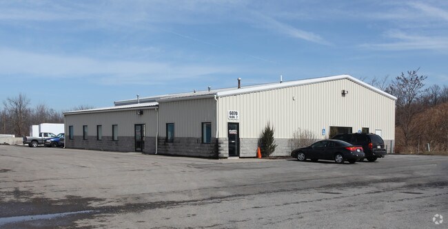
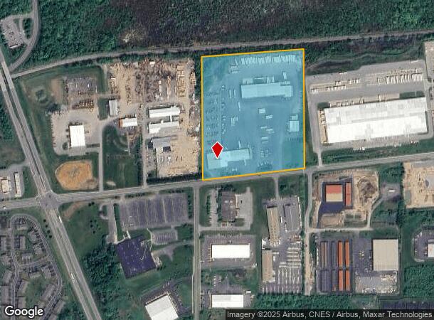
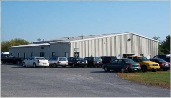
Property Record
6070 Collett Rd, Farmington, NY 14425
NEARBY LISTINGS FOR SALE OR LEASE
Property Detail
6070 Collett Rd
Rochester, NY
Ontario
322800-029-000-0001-008-111
New York
Truckterminal
8.111
2025
18.20 AC
2024
Outlying Ontario County
050206
Rochester
58,000 SF
DEMOGRAPHICS near 6070 Collett Rd
1 Mile
3 Mile
5 Mile
2024 Total Population
4,639
20,062
30,780
2029 Population
4,689
20,076
30,837
Pop Growth 2024-2029
+ 1.08%
+ 0.07%
+ 0.19%
Average Age
39
40
41
2024 Total Households
2,020
8,083
12,370
HH Growth 2024-2029
+ 0.79%
(0.12%)
+ 0.06%
Median Household Inc
$65,182
$80,241
$88,309
Avg Household Size
2.30
2.40
2.50
2024 Avg HH Vehicles
2.00
2.00
2.00
Median Home Value
$150,238
$196,943
$232,522
Median Year Built
1995
1991
1992
Nearby Places
- Restaurants
- Banks
- Shops
- Fitness
- Groceries
PUBLIC TRANSPORTATION
AIRPORT
Frederick Douglass/Greater Rochester International
DRIVE
WALK
Distance
Frederick Douglass/Greater Rochester International
32 min
22.4 mi
Freight Ports
Albany, NY Port
DRIVE
WALK
Distance
Albany, NY Port
244 min
208.6 mi
Nearby Properties
Address
Land Use
TOTAL SIZE
Lot Size
Zoning
Address
Land Use
TOTAL SIZE
Lot Size
Zoning
86 AC
04 - FARM
Address
Land Use
TOTAL SIZE
Lot Size
Zoning
2,728 SF
229 AC
05 - COMME
Address
Land Use
TOTAL SIZE
Lot Size
Zoning
21.30 AC
06 - INDUS
Address
Land Use
TOTAL SIZE
Lot Size
Zoning
225,200 SF
26.80 AC
06 - INDUS
Address
Land Use
TOTAL SIZE
Lot Size
Zoning
551 SF
23.47 AC
R2-B
Address
Land Use
TOTAL SIZE
Lot Size
Zoning
86,970 SF
25.70 AC
R-1
Address
Land Use
TOTAL SIZE
Lot Size
Zoning
Address
Land Use
TOTAL SIZE
Lot Size
Zoning
3,816 SF
32.10 AC
05 - COMME
Address
Land Use
TOTAL SIZE
Lot Size
Zoning
Address
Land Use
TOTAL SIZE
Lot Size
Zoning
8,400 SF
19 AC
03 - MULTI
Address
Land Use
TOTAL SIZE
Lot Size
Zoning
3,792 SF
24.50 AC
03 - MULTI
Address
Land Use
TOTAL SIZE
Lot Size
Zoning
3,864 SF
39 AC
MH
Address
Land Use
TOTAL SIZE
Lot Size
Zoning
192,576 SF
14 AC
R-1
Address
Land Use
TOTAL SIZE
Lot Size
Zoning
8,298 SF
10.10 AC
06 - INDUS
Address
Land Use
TOTAL SIZE
Lot Size
Zoning
5,539 SF
15.20 AC
06 - INDUS
Address
Land Use
TOTAL SIZE
Lot Size
Zoning
40,000 SF
14.90 AC
05 - COMME
Address
Land Use
TOTAL SIZE
Lot Size
Zoning
7,735 SF
8.40 AC
03 - MULTI
Address
Land Use
TOTAL SIZE
Lot Size
Zoning
460 SF
49 AC
03 - MULTI
Address
Land Use
TOTAL SIZE
Lot Size
Zoning
3,791 SF
12.10 AC
06 - INDUS
Address
Land Use
TOTAL SIZE
Lot Size
Zoning
51,151 SF
14.20 AC
05 - COMME
Address
Land Use
TOTAL SIZE
Lot Size
Zoning
42.30 AC
05 - COMME
Address
Land Use
TOTAL SIZE
Lot Size
Zoning
4,812 SF
16.20 AC
PDD
Address
Land Use
TOTAL SIZE
Lot Size
Zoning
Address
Land Use
TOTAL SIZE
Lot Size
Zoning
149,084 SF
19.50 AC
06 - INDUS
Address
Land Use
TOTAL SIZE
Lot Size
Zoning
192,000 SF
14.90 AC
05 - COMME
Address
Land Use
TOTAL SIZE
Lot Size
Zoning
8,824 SF
15 AC
03 - MULTI
Address
Land Use
TOTAL SIZE
Lot Size
Zoning
Address
Land Use
TOTAL SIZE
Lot Size
Zoning
5,134 SF
9.10 AC
C-LI
Address
Land Use
TOTAL SIZE
Lot Size
Zoning
29,900 SF
2.10 AC
05 - COMME
Address
Land Use
TOTAL SIZE
Lot Size
Zoning
6,332 SF
11.50 AC
03 - MULTI
The World's #1 Commercial Real Estate Marketplace
Connect with us
© 2025 CoStar Group
The information above has been obtained from sources believed reliable. While we do not doubt its accuracy we have not verified it and make no guarantee, warranty or representation about it. It is your responsibility to independently confirm its accuracy and completeness. Any projections, opinions, assumptions, or estimates used are for example only and do not represent the current or future performance of the property. The value of this transaction to you depends on tax and other factors which should be evaluated by your tax, financial, and legal advisors. You and your advisors should conduct a careful, independent investigation of the property to determine to your satisfaction the suitability of the property for your needs.