Property Record
6070 Fm 2920 Rd, Spring, TX 77379
NEARBY LISTINGS FOR SALE OR LEASE
Property Detail
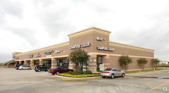
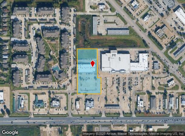
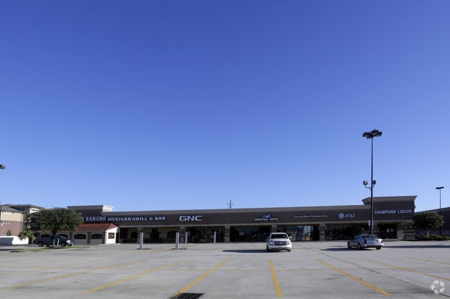
6070 Fm 2920 Rd
1235750010003
Klein Crossing Shopping Cntr1
Regionalshoppingcenterormallwithanchorstore
RES C BLK 1 KLEIN CROSSING SHOPPING CNTR 1
X
Harris
48201C0235M
Texas
2024
2.74 AC
2025
Far North
553804
Houston
16,800 SF
Houston-Pasadena-The Woodlands, TX
DEMOGRAPHICS near 6070 Fm 2920 Rd
1 mile
3 mile
5 mile
2024 Total Population
12,207
75,847
221,866
2029 Population
12,373
77,860
229,094
Pop Growth 2024-2029
+ 1.36%
+ 2.65%
+ 3.26%
Average Age
35
36
37
2024 Total Households
3,995
24,419
75,642
HH Growth 2024-2029
+ 1.33%
+ 2.56%
+ 3.55%
Median Household Inc
$106,016
$99,197
$99,370
Avg Household Size
3.00
3.00
2.90
2024 Avg HH Vehicles
2.00
2.00
2.00
Median Home Value
$253,671
$266,293
$278,569
Median Year Built
2006
2004
2003
Nearby Places
Map Layers
Map Styles
 Street
 Aerial
Transit
 Traffic
 Biking
Places
Listings with unknown addresses are not visible on the map
- Restaurants
- Banks
- Shops
- Fitness
- Groceries
PUBLIC TRANSPORTATION
AIRPORT
George Bush Intcntl/Houston
Drive
Walk
Distance
George Bush Intcntl/Houston
29 min
20.7 mi
Freight Ports
Port of Houston
Drive
Walk
Distance
Port of Houston
50 min
35.0 mi
SALE & LEASE HISTORY
LISTING DATE
SALE/LEASE

Feb 03, 2025
For Lease
Nearby Properties
Address
Land Use
TOTAL SIZE
Lot Size
Zoning
Address
Land Use
TOTAL SIZE
Lot Size
Zoning
382,636 SF
25.51 AC
Address
Land Use
TOTAL SIZE
Lot Size
Zoning
379,180 SF
15.52 AC
Address
Land Use
TOTAL SIZE
Lot Size
Zoning
320,507 SF
25.29 AC
Address
Land Use
TOTAL SIZE
Lot Size
Zoning
156,885 SF
26.24 AC
Address
Land Use
TOTAL SIZE
Lot Size
Zoning
341,895 SF
17.53 AC
Address
Land Use
TOTAL SIZE
Lot Size
Zoning
375,293 SF
19.29 AC
Address
Land Use
TOTAL SIZE
Lot Size
Zoning
394,700 SF
17.34 AC
Address
Land Use
TOTAL SIZE
Lot Size
Zoning
343,806 SF
17.76 AC
Address
Land Use
TOTAL SIZE
Lot Size
Zoning
335,258 SF
12.18 AC
Address
Land Use
TOTAL SIZE
Lot Size
Zoning
328,692 SF
18.47 AC
Address
Land Use
TOTAL SIZE
Lot Size
Zoning
322,733 SF
18.40 AC
Address
Land Use
TOTAL SIZE
Lot Size
Zoning
266,594 SF
10.71 AC
Address
Land Use
TOTAL SIZE
Lot Size
Zoning
413,131 SF
12.52 AC
Address
Land Use
TOTAL SIZE
Lot Size
Zoning
249,950 SF
15.92 AC
Address
Land Use
TOTAL SIZE
Lot Size
Zoning
281,166 SF
22.14 AC
Address
Land Use
TOTAL SIZE
Lot Size
Zoning
267,082 SF
11.13 AC
Address
Land Use
TOTAL SIZE
Lot Size
Zoning
241,113 SF
6.29 AC
Address
Land Use
TOTAL SIZE
Lot Size
Zoning
188,265 SF
15.65 AC
Address
Land Use
TOTAL SIZE
Lot Size
Zoning
253,800 SF
43.72 AC
Address
Land Use
TOTAL SIZE
Lot Size
Zoning
219,000 SF
46.59 AC
Address
Land Use
TOTAL SIZE
Lot Size
Zoning
800 SF
23.53 AC
Address
Land Use
TOTAL SIZE
Lot Size
Zoning
114,917 SF
18.61 AC
Address
Land Use
TOTAL SIZE
Lot Size
Zoning
145,051 SF
6.10 AC
Address
Land Use
TOTAL SIZE
Lot Size
Zoning
214,862 SF
14.92 AC
Address
Land Use
TOTAL SIZE
Lot Size
Zoning
224,669 SF
15.40 AC
Address
Land Use
TOTAL SIZE
Lot Size
Zoning
96,300 SF
21.59 AC
Address
Land Use
TOTAL SIZE
Lot Size
Zoning
118,475 SF
3.89 AC
Address
Land Use
TOTAL SIZE
Lot Size
Zoning
211,876 SF
21.78 AC
Address
Land Use
TOTAL SIZE
Lot Size
Zoning
202,728 SF
3.50 AC
Address
Land Use
TOTAL SIZE
Lot Size
Zoning
82,892 SF
8.91 AC
The World's #1 Commercial Real Estate Marketplace
Connect with us
© 2026 CoStar Group
The information above has been obtained from sources believed reliable. While we do not doubt its accuracy we have not verified it and make no guarantee, warranty or representation about it. It is your responsibility to independently confirm its accuracy and completeness. Any projections, opinions, assumptions, or estimates used are for example only and do not represent the current or future performance of the property. The value of this transaction to you depends on tax and other factors which should be evaluated by your tax, financial, and legal advisors. You and your advisors should conduct a careful, independent investigation of the property to determine to your satisfaction the suitability of the property for your needs.