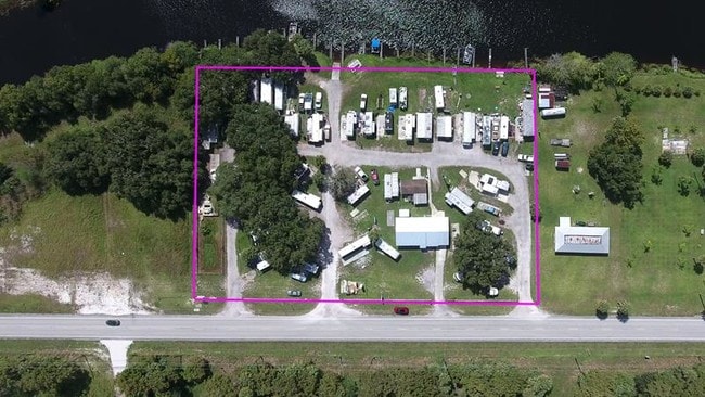
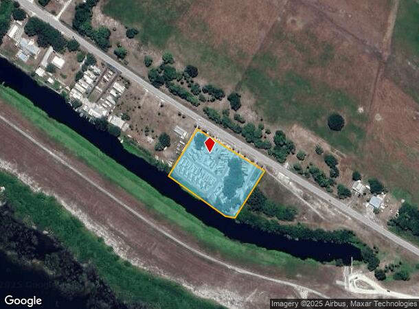
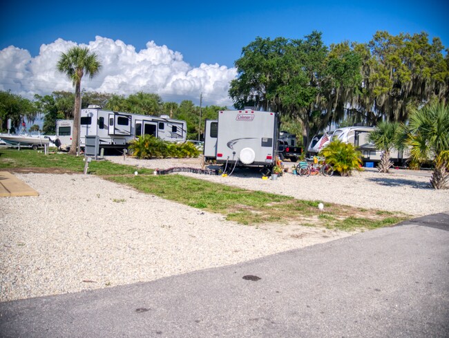
Property Record
6070 Us Highway 441 Se, Okeechobee, FL 34974
NEARBY LISTINGS FOR SALE OR LEASE
Property Detail
6070 Us Highway 441 Se
Okeechobee, FL
The North Boundary
R1-06-38-36-0A00-00014-0000
BEGINNING AT THE INTERSECTION OF THE SOUTH RIGHT-OF-WAY LINE OF STATE ROAD #15 (CONNERS HIGHWAY) WITH THE NORTH BOUNDARY LINE OF NORTH SHORE LEVEE AND RUN NORTHWESTERLY ALONG THE SOUTH BOUNDARY LINE OF STATE ROAD #15 (CONNERS HIGHWAY) FOR A DISTANCE
Parkinglot
Okeechobee
AE
Florida
12043C0100D
3
2025
2.64 AC
2025
Florida Central South Area
910403
Other Market Areas
1,660 SF
DEMOGRAPHICS near 6070 Us Highway 441 Se
1 Mile
3 Mile
5 Mile
2024 Total Population
1,759
8,244
18,943
2029 Population
1,868
8,847
20,330
Pop Growth 2024-2029
+ 6.20%
+ 7.31%
+ 7.32%
Average Age
47
47
45
2024 Total Households
822
3,798
7,967
HH Growth 2024-2029
+ 6.45%
+ 7.40%
+ 7.68%
Median Household Inc
$49,347
$42,392
$41,656
Avg Household Size
2.10
2.10
2.30
2024 Avg HH Vehicles
2.00
2.00
2.00
Median Home Value
$116,791
$113,034
$118,552
Median Year Built
1990
1987
1988
Nearby Places
Map Layers
Map Styles
 Street
 Aerial
- Restaurants
- Banks
- Shops
- Fitness
- Groceries
PUBLIC TRANSPORTATION
COMMUTER RAIL
Okeechobee Amtrak (Silver Star - Amtrak)
DRIVE
WALK
Distance
Okeechobee Amtrak (Silver Star - Amtrak)
15 min
7.3 mi
Freight Ports
Port of Palm Beach
DRIVE
WALK
Distance
Port of Palm Beach
78 min
54.9 mi
SALE & LEASE HISTORY
LISTING DATE
SALE/LEASE

Oct 15, 2021
For Sale
Nov 18, 2019
For Sale
Mar 23, 2022
For Sale
Nearby Properties
Address
Land Use
TOTAL SIZE
Lot Size
Zoning
Address
Land Use
TOTAL SIZE
Lot Size
Zoning
1,600 SF
424.34 AC
Address
Land Use
TOTAL SIZE
Lot Size
Zoning
486.65 AC
Address
Land Use
TOTAL SIZE
Lot Size
Zoning
9,231 SF
10.56 AC
Address
Land Use
TOTAL SIZE
Lot Size
Zoning
75,023 SF
14.50 AC
Address
Land Use
TOTAL SIZE
Lot Size
Zoning
2,887 SF
11.76 AC
Address
Land Use
TOTAL SIZE
Lot Size
Zoning
51,475 SF
8.66 AC
Address
Land Use
TOTAL SIZE
Lot Size
Zoning
4,293 SF
14.62 AC
Address
Land Use
TOTAL SIZE
Lot Size
Zoning
237.55 AC
Address
Land Use
TOTAL SIZE
Lot Size
Zoning
8,954 SF
3.41 AC
Address
Land Use
TOTAL SIZE
Lot Size
Zoning
2,778 SF
5.30 AC
Address
Land Use
TOTAL SIZE
Lot Size
Zoning
23,041 SF
10.13 AC
Address
Land Use
TOTAL SIZE
Lot Size
Zoning
117.12 AC
Address
Land Use
TOTAL SIZE
Lot Size
Zoning
22,440 SF
7.70 AC
Address
Land Use
TOTAL SIZE
Lot Size
Zoning
8,151 SF
2.07 AC
Address
Land Use
TOTAL SIZE
Lot Size
Zoning
2,872 SF
1.57 AC
Address
Land Use
TOTAL SIZE
Lot Size
Zoning
13,598 SF
9.10 AC
Address
Land Use
TOTAL SIZE
Lot Size
Zoning
17,931 SF
5.18 AC
Address
Land Use
TOTAL SIZE
Lot Size
Zoning
2,730 SF
4.02 AC
Address
Land Use
TOTAL SIZE
Lot Size
Zoning
75.66 AC
Address
Land Use
TOTAL SIZE
Lot Size
Zoning
10,729 SF
1.31 AC
Address
Land Use
TOTAL SIZE
Lot Size
Zoning
10,387 SF
1.93 AC
Address
Land Use
TOTAL SIZE
Lot Size
Zoning
1,540 SF
9.42 AC
Address
Land Use
TOTAL SIZE
Lot Size
Zoning
29,720 SF
2.63 AC
Address
Land Use
TOTAL SIZE
Lot Size
Zoning
191.37 AC
Address
Land Use
TOTAL SIZE
Lot Size
Zoning
69.89 AC
Address
Land Use
TOTAL SIZE
Lot Size
Zoning
3,098 SF
1.42 AC
Address
Land Use
TOTAL SIZE
Lot Size
Zoning
11,318 SF
1.81 AC
Address
Land Use
TOTAL SIZE
Lot Size
Zoning
4,591 SF
1.45 AC
Address
Land Use
TOTAL SIZE
Lot Size
Zoning
14,427 SF
78.71 AC
The World's #1 Commercial Real Estate Marketplace
Connect with us
© 2026 CoStar Group
The information above has been obtained from sources believed reliable. While we do not doubt its accuracy we have not verified it and make no guarantee, warranty or representation about it. It is your responsibility to independently confirm its accuracy and completeness. Any projections, opinions, assumptions, or estimates used are for example only and do not represent the current or future performance of the property. The value of this transaction to you depends on tax and other factors which should be evaluated by your tax, financial, and legal advisors. You and your advisors should conduct a careful, independent investigation of the property to determine to your satisfaction the suitability of the property for your needs.