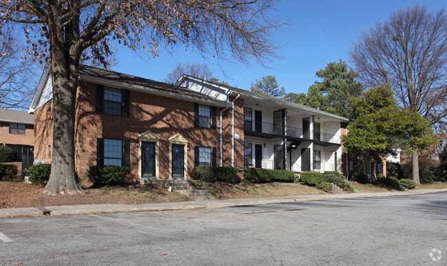
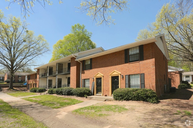
Property Record
6071 Highway 85, Riverdale, GA 30274


NEARBY LISTINGS FOR SALE OR LEASE
-
-
View all Riverdale listings for sale on LoopNet.com
Property Detail
6071 Highway 85
13-0119B-00A-003A
Clayton
Gardenaptcourtapt5plusunits
Georgia
X
118
13063C0058F
27.60 AC
2025
Clayton County
2025
Atlanta
040519
Atlanta-Sandy Springs-Roswell, GA
114 SF
DEMOGRAPHICS near 6071 Highway 85
1 Mile
3 Mile
5 Mile
2024 Total Population
12,174
77,860
185,584
2029 Population
12,114
77,468
186,841
Pop Growth 2024-2029
(0.49%)
(0.50%)
+ 0.68%
Average Age
34
35
36
2024 Total Households
5,376
29,571
68,764
HH Growth 2024-2029
(0.45%)
(0.56%)
+ 0.73%
Median Household Inc
$39,411
$42,599
$46,935
Avg Household Size
2.20
2.60
2.60
2024 Avg HH Vehicles
1.00
2.00
2.00
Median Home Value
$135,133
$147,931
$155,655
Median Year Built
1986
1981
1981
Nearby Places
Map Layers
Map Styles
 Street
 Aerial
- Restaurants
- Banks
- Shops
- Fitness
- Groceries
PUBLIC TRANSPORTATION
AIRPORT
Hartsfield - Jackson Atlanta International
DRIVE
WALK
Distance
Hartsfield - Jackson Atlanta International
13 min
5.9 mi
Nearby Properties
Address
Land Use
TOTAL SIZE
Lot Size
Zoning
Address
Land Use
TOTAL SIZE
Lot Size
Zoning
518,648 SF
31.03 AC
MCD
Address
Land Use
TOTAL SIZE
Lot Size
Zoning
274.75 AC
HI
Address
Land Use
TOTAL SIZE
Lot Size
Zoning
229.84 AC
HI
Address
Land Use
TOTAL SIZE
Lot Size
Zoning
596 SF
57.40 AC
RM
Address
Land Use
TOTAL SIZE
Lot Size
Zoning
699 SF
44.34 AC
RM
Address
Land Use
TOTAL SIZE
Lot Size
Zoning
352 SF
32.69 AC
RM
Address
Land Use
TOTAL SIZE
Lot Size
Zoning
370 SF
36.20 AC
RM
Address
Land Use
TOTAL SIZE
Lot Size
Zoning
264 SF
24.92 AC
RM
Address
Land Use
TOTAL SIZE
Lot Size
Zoning
212,048 SF
110.06 AC
HI
Address
Land Use
TOTAL SIZE
Lot Size
Zoning
387 SF
32.53 AC
RM
Address
Land Use
TOTAL SIZE
Lot Size
Zoning
96,028 SF
21.02 AC
I
Address
Land Use
TOTAL SIZE
Lot Size
Zoning
252 SF
27.14 AC
RM
Address
Land Use
TOTAL SIZE
Lot Size
Zoning
216 SF
24.45 AC
RM
Address
Land Use
TOTAL SIZE
Lot Size
Zoning
200 SF
20.71 AC
RM
Address
Land Use
TOTAL SIZE
Lot Size
Zoning
190 SF
21.66 AC
RM
Address
Land Use
TOTAL SIZE
Lot Size
Zoning
410 SF
35 AC
RM
Address
Land Use
TOTAL SIZE
Lot Size
Zoning
167,008 SF
36.21 AC
HI
Address
Land Use
TOTAL SIZE
Lot Size
Zoning
178,002 SF
39.88 AC
OI
Address
Land Use
TOTAL SIZE
Lot Size
Zoning
240 SF
28.43 AC
RM
Address
Land Use
TOTAL SIZE
Lot Size
Zoning
45.64 AC
HI
Address
Land Use
TOTAL SIZE
Lot Size
Zoning
422,480 SF
19.42 AC
HI
Address
Land Use
TOTAL SIZE
Lot Size
Zoning
240 SF
27 AC
HI
Address
Land Use
TOTAL SIZE
Lot Size
Zoning
296 SF
27.93 AC
RM
Address
Land Use
TOTAL SIZE
Lot Size
Zoning
9.05 AC
C
Address
Land Use
TOTAL SIZE
Lot Size
Zoning
411,859 SF
15.80 AC
I
Address
Land Use
TOTAL SIZE
Lot Size
Zoning
388,552 SF
3.50 AC
I
Address
Land Use
TOTAL SIZE
Lot Size
Zoning
198 SF
32.10 AC
RM
Address
Land Use
TOTAL SIZE
Lot Size
Zoning
208 SF
19.26 AC
RM
Address
Land Use
TOTAL SIZE
Lot Size
Zoning
203,067 SF
18 AC
C
Address
Land Use
TOTAL SIZE
Lot Size
Zoning
180,300 SF
12.77 AC
WH
The World's #1 Commercial Real Estate Marketplace
Connect with us
© 2025 CoStar Group
The information above has been obtained from sources believed reliable. While we do not doubt its accuracy we have not verified it and make no guarantee, warranty or representation about it. It is your responsibility to independently confirm its accuracy and completeness. Any projections, opinions, assumptions, or estimates used are for example only and do not represent the current or future performance of the property. The value of this transaction to you depends on tax and other factors which should be evaluated by your tax, financial, and legal advisors. You and your advisors should conduct a careful, independent investigation of the property to determine to your satisfaction the suitability of the property for your needs.