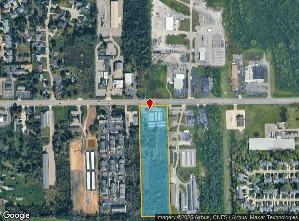
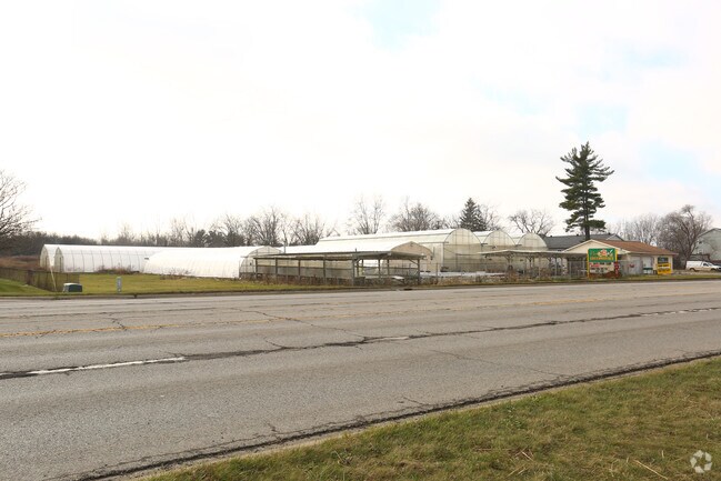
Property Record
6073 W Pierson Rd, Flushing, MI 48433

NEARBY LISTINGS FOR SALE OR LEASE
Property Detail
6073 W Pierson Rd
14-31-200-013
A PARCEL OF LAND BEG 30 RDS W OF NE COR OF SEC 31 TH W 20 RDS TH S 80 RDS TH E 20 RDS TH N 80 RDS TO PLACE OF BEG SEC 31 T8N
Commercialnec
Genesee
X
Michigan
26049C0166D
10 AC
2024
Flint
2025
Detroit
010502
Flint, MI
DEMOGRAPHICS near 6073 W Pierson Rd
1 Mile
3 Mile
5 Mile
2024 Total Population
1,872
22,548
88,356
2029 Population
1,812
21,955
88,664
Pop Growth 2024-2029
(3.21%)
(2.63%)
+ 0.35%
Average Age
40
43
41
2024 Total Households
759
9,159
36,291
HH Growth 2024-2029
(3.43%)
(2.67%)
+ 0.33%
Median Household Inc
$55,765
$62,147
$45,648
Avg Household Size
2.30
2.40
2.30
2024 Avg HH Vehicles
2.00
2.00
2.00
Median Home Value
$145,945
$170,012
$102,978
Median Year Built
1967
1971
1965
Nearby Places
Map Layers
Map Styles
 Street
 Aerial
- Restaurants
- Banks
- Shops
- Fitness
- Groceries
PUBLIC TRANSPORTATION
AIRPORT
Bishop International
DRIVE
WALK
Distance
Bishop International
25 min
11.8 mi
MBS International
DRIVE
WALK
Distance
MBS International
61 min
47.3 mi
SALE & LEASE HISTORY
LISTING DATE
SALE/LEASE

Sep 24, 2016
For Sale
Feb 22, 2019
For Sale
Nearby Properties
Address
Land Use
TOTAL SIZE
Lot Size
Zoning
Address
Land Use
TOTAL SIZE
Lot Size
Zoning
72,367 SF
10.60 AC
R3-B (HDR)
Address
Land Use
TOTAL SIZE
Lot Size
Zoning
157,068 SF
160 AC
Address
Land Use
TOTAL SIZE
Lot Size
Zoning
11.97 AC
Address
Land Use
TOTAL SIZE
Lot Size
Zoning
10.30 AC
Address
Land Use
TOTAL SIZE
Lot Size
Zoning
41,298 SF
9.49 AC
Address
Land Use
TOTAL SIZE
Lot Size
Zoning
59,173 SF
11.43 AC
Address
Land Use
TOTAL SIZE
Lot Size
Zoning
11.12 AC
Address
Land Use
TOTAL SIZE
Lot Size
Zoning
9.46 AC
Address
Land Use
TOTAL SIZE
Lot Size
Zoning
13.20 AC
Address
Land Use
TOTAL SIZE
Lot Size
Zoning
Address
Land Use
TOTAL SIZE
Lot Size
Zoning
2.45 AC
Address
Land Use
TOTAL SIZE
Lot Size
Zoning
5.10 AC
Address
Land Use
TOTAL SIZE
Lot Size
Zoning
62,121 SF
6.23 AC
B-2 CC GEN
Address
Land Use
TOTAL SIZE
Lot Size
Zoning
104.81 AC
Address
Land Use
TOTAL SIZE
Lot Size
Zoning
Address
Land Use
TOTAL SIZE
Lot Size
Zoning
5.70 AC
Address
Land Use
TOTAL SIZE
Lot Size
Zoning
2.02 AC
Address
Land Use
TOTAL SIZE
Lot Size
Zoning
1.41 AC
Address
Land Use
TOTAL SIZE
Lot Size
Zoning
3.32 AC
Address
Land Use
TOTAL SIZE
Lot Size
Zoning
100,022 SF
92 AC
Address
Land Use
TOTAL SIZE
Lot Size
Zoning
22,669 SF
6.89 AC
Address
Land Use
TOTAL SIZE
Lot Size
Zoning
21,763 SF
4.36 AC
B-2 CC GEN
Address
Land Use
TOTAL SIZE
Lot Size
Zoning
31,008 SF
6.14 AC
R3-B (HDR)
Address
Land Use
TOTAL SIZE
Lot Size
Zoning
18.66 AC
Address
Land Use
TOTAL SIZE
Lot Size
Zoning
3.52 AC
Address
Land Use
TOTAL SIZE
Lot Size
Zoning
2.74 AC
Address
Land Use
TOTAL SIZE
Lot Size
Zoning
Address
Land Use
TOTAL SIZE
Lot Size
Zoning
12,500 SF
6.84 AC
Address
Land Use
TOTAL SIZE
Lot Size
Zoning
34,708 SF
5.05 AC
B-2 CC GEN
Address
Land Use
TOTAL SIZE
Lot Size
Zoning
31.55 AC
The World's #1 Commercial Real Estate Marketplace
Connect with us
© 2025 CoStar Group
The information above has been obtained from sources believed reliable. While we do not doubt its accuracy we have not verified it and make no guarantee, warranty or representation about it. It is your responsibility to independently confirm its accuracy and completeness. Any projections, opinions, assumptions, or estimates used are for example only and do not represent the current or future performance of the property. The value of this transaction to you depends on tax and other factors which should be evaluated by your tax, financial, and legal advisors. You and your advisors should conduct a careful, independent investigation of the property to determine to your satisfaction the suitability of the property for your needs.