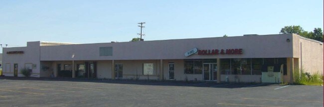
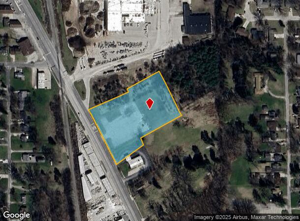
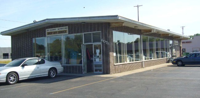
Property Record
6075 Dixie Hwy, Bridgeport, MI 48722
NEARBY LISTINGS FOR SALE OR LEASE
Property Detail
6075 Dixie Hwy
09115160238800
Bridgeport Village
Commercialacreage
COM AT N 1/4 CORN OF SEC 16 TH E 1313.90 FT TO E 1/8 LINE TH S 580 FT TH S61DEG W 284.46 FT TO POB TH S28DEG E 20 FT TH S61DEG W 259.18 FT TH S26DEG E 17.87 FT TH S53DEG W 200 FT TH N26DEG W 19 FT TO A DEFLECTION PT TH N28DEG W 229 FT TH N61DEG E 254
X
Saginaw
26145C0332E
Michigan
0
2.58 AC
2025
Midland/Flint
011600
Other Market Areas
21,554 SF
Saginaw, MI
DEMOGRAPHICS near 6075 Dixie Hwy
1 Mile
3 Mile
5 Mile
2024 Total Population
1,902
12,485
36,383
2029 Population
1,872
12,396
36,698
Pop Growth 2024-2029
(1.58%)
(0.71%)
+ 0.87%
Average Age
43
42
40
2024 Total Households
787
5,238
15,138
HH Growth 2024-2029
(1.65%)
(0.92%)
+ 0.73%
Median Household Inc
$38,499
$37,896
$30,683
Avg Household Size
2.30
2.30
2.30
2024 Avg HH Vehicles
2.00
2.00
1.00
Median Home Value
$90,508
$75,701
$69,443
Median Year Built
1965
1965
1961
Nearby Places
Map Layers
Map Styles
 Street
 Aerial
- Restaurants
- Banks
- Shops
- Fitness
- Groceries
PUBLIC TRANSPORTATION
AIRPORT
MBS International
DRIVE
WALK
Distance
MBS International
37 min
21.3 mi
Bishop International
DRIVE
WALK
Distance
Bishop International
48 min
33.1 mi
Nearby Properties
Address
Land Use
TOTAL SIZE
Lot Size
Zoning
Address
Land Use
TOTAL SIZE
Lot Size
Zoning
600,385 SF
33.54 AC
Address
Land Use
TOTAL SIZE
Lot Size
Zoning
153,565 SF
10.87 AC
R-3 RES
Address
Land Use
TOTAL SIZE
Lot Size
Zoning
34,056 SF
3.46 AC
Address
Land Use
TOTAL SIZE
Lot Size
Zoning
137,566 SF
21.60 AC
B2- COM
Address
Land Use
TOTAL SIZE
Lot Size
Zoning
25,163 SF
28.65 AC
B3
Address
Land Use
TOTAL SIZE
Lot Size
Zoning
82,868 SF
17.56 AC
M1
Address
Land Use
TOTAL SIZE
Lot Size
Zoning
136,453 SF
13.44 AC
R-3 RES
Address
Land Use
TOTAL SIZE
Lot Size
Zoning
85,028 SF
9.11 AC
Address
Land Use
TOTAL SIZE
Lot Size
Zoning
65,930 SF
9.91 AC
Address
Land Use
TOTAL SIZE
Lot Size
Zoning
104,165 SF
10.47 AC
R-3 RES
Address
Land Use
TOTAL SIZE
Lot Size
Zoning
212,454 SF
8.80 AC
M2
Address
Land Use
TOTAL SIZE
Lot Size
Zoning
44,730 SF
4.20 AC
R-1 RES
Address
Land Use
TOTAL SIZE
Lot Size
Zoning
24,960 SF
22.36 AC
B3
Address
Land Use
TOTAL SIZE
Lot Size
Zoning
119,392 SF
77.98 AC
M2
Address
Land Use
TOTAL SIZE
Lot Size
Zoning
70,966 SF
5.38 AC
M2
Address
Land Use
TOTAL SIZE
Lot Size
Zoning
3,752 SF
11.42 AC
Address
Land Use
TOTAL SIZE
Lot Size
Zoning
45,526 SF
3.58 AC
Address
Land Use
TOTAL SIZE
Lot Size
Zoning
32,365 SF
3.59 AC
R-2 RES
Address
Land Use
TOTAL SIZE
Lot Size
Zoning
55,944 SF
0.64 AC
Address
Land Use
TOTAL SIZE
Lot Size
Zoning
43,212 SF
3.59 AC
B3
Address
Land Use
TOTAL SIZE
Lot Size
Zoning
Address
Land Use
TOTAL SIZE
Lot Size
Zoning
41,742 SF
6.37 AC
M2
Address
Land Use
TOTAL SIZE
Lot Size
Zoning
53,974 SF
2.41 AC
Address
Land Use
TOTAL SIZE
Lot Size
Zoning
53,450 SF
5.11 AC
Address
Land Use
TOTAL SIZE
Lot Size
Zoning
47,840 SF
10.61 AC
M2
Address
Land Use
TOTAL SIZE
Lot Size
Zoning
42,728 SF
8.51 AC
Address
Land Use
TOTAL SIZE
Lot Size
Zoning
3,228 SF
55.52 AC
R-3 RES
Address
Land Use
TOTAL SIZE
Lot Size
Zoning
15,183 SF
11.46 AC
Address
Land Use
TOTAL SIZE
Lot Size
Zoning
55,720 SF
7.24 AC
M1
Address
Land Use
TOTAL SIZE
Lot Size
Zoning
58,072 SF
5.45 AC
The World's #1 Commercial Real Estate Marketplace
Connect with us
© 2025 CoStar Group
The information above has been obtained from sources believed reliable. While we do not doubt its accuracy we have not verified it and make no guarantee, warranty or representation about it. It is your responsibility to independently confirm its accuracy and completeness. Any projections, opinions, assumptions, or estimates used are for example only and do not represent the current or future performance of the property. The value of this transaction to you depends on tax and other factors which should be evaluated by your tax, financial, and legal advisors. You and your advisors should conduct a careful, independent investigation of the property to determine to your satisfaction the suitability of the property for your needs.