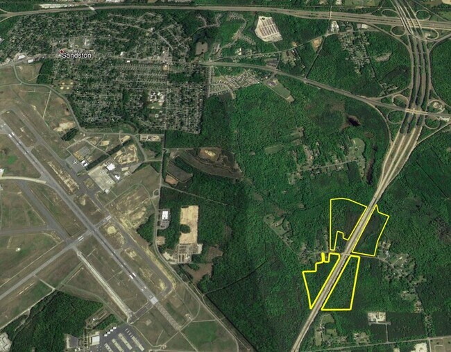
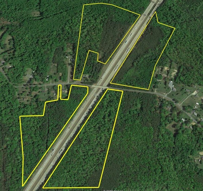
Property Record
6070 La France Rd, Sandston, VA 23150
NEARBY LISTINGS FOR SALE OR LEASE
Property Detail
6070 La France Rd
833-706-5820
01850A0000 0030; OLD LAFRANCE RD AC 17.498 PAR B 43 B2 50
Vacantlandnec
Henrico
X
Virginia
51087C0235D
27.41 AC
2025
East End
2025
Richmond VA
201404
Richmond, VA
DEMOGRAPHICS near 6070 La France Rd
1 Mile
3 Mile
5 Mile
2024 Total Population
186
8,944
37,313
2029 Population
186
8,901
37,300
Pop Growth 2024-2029
0.00%
(0.48%)
(0.03%)
Average Age
43
42
41
2024 Total Households
79
3,632
14,883
HH Growth 2024-2029
0.00%
(0.47%)
(0.07%)
Median Household Inc
$75,568
$69,486
$68,735
Avg Household Size
2.40
2.40
2.40
2024 Avg HH Vehicles
2.00
2.00
2.00
Median Home Value
$250,000
$221,131
$221,723
Median Year Built
1975
1974
1980
Nearby Places
Map Layers
Map Styles
 Street
 Aerial
- Restaurants
- Banks
- Shops
- Fitness
- Groceries
PUBLIC TRANSPORTATION
AIRPORT
Richmond International
DRIVE
WALK
Distance
Richmond International
7 min
2.0 mi
Freight Ports
Virginia Port Authority - Richmond
DRIVE
WALK
Distance
Virginia Port Authority - Richmond
29 min
15.0 mi
SALE & LEASE HISTORY
LISTING DATE
SALE/LEASE

Feb 27, 2020
For Sale
Nearby Properties
Address
Land Use
TOTAL SIZE
Lot Size
Zoning
Address
Land Use
TOTAL SIZE
Lot Size
Zoning
548,680 SF
2,298.89 AC
MIXE
Address
Land Use
TOTAL SIZE
Lot Size
Zoning
385,896 SF
128.24 AC
M-2
Address
Land Use
TOTAL SIZE
Lot Size
Zoning
382,408 SF
65 AC
M-2
Address
Land Use
TOTAL SIZE
Lot Size
Zoning
341,614 SF
16.10 AC
M-2
Address
Land Use
TOTAL SIZE
Lot Size
Zoning
339,884 SF
22.48 AC
M-2
Address
Land Use
TOTAL SIZE
Lot Size
Zoning
716,824 SF
60.89 AC
M-2C
Address
Land Use
TOTAL SIZE
Lot Size
Zoning
446,500 SF
49.33 AC
M1-C
Address
Land Use
TOTAL SIZE
Lot Size
Zoning
278,967 SF
26.07 AC
M1-C
Address
Land Use
TOTAL SIZE
Lot Size
Zoning
181,200 SF
14.74 AC
R-5
Address
Land Use
TOTAL SIZE
Lot Size
Zoning
142,379 SF
17.69 AC
M-1
Address
Land Use
TOTAL SIZE
Lot Size
Zoning
212,576 SF
94.90 AC
MIXE
Address
Land Use
TOTAL SIZE
Lot Size
Zoning
53,530 SF
4.50 AC
M-1C
Address
Land Use
TOTAL SIZE
Lot Size
Zoning
63,700 SF
19.50 AC
A-1
Address
Land Use
TOTAL SIZE
Lot Size
Zoning
130,638 SF
11.06 AC
R-5
Address
Land Use
TOTAL SIZE
Lot Size
Zoning
1,546 SF
43.18 AC
MIXE
Address
Land Use
TOTAL SIZE
Lot Size
Zoning
5,918 SF
41.66 AC
M-2
Address
Land Use
TOTAL SIZE
Lot Size
Zoning
97,132 SF
7.88 AC
MIXE
Address
Land Use
TOTAL SIZE
Lot Size
Zoning
120,860 SF
15.03 AC
M1-C
Address
Land Use
TOTAL SIZE
Lot Size
Zoning
42,755 SF
103.73 AC
M-1
Address
Land Use
TOTAL SIZE
Lot Size
Zoning
123,668 SF
125.60 AC
A-1
Address
Land Use
TOTAL SIZE
Lot Size
Zoning
69,405 SF
14.13 AC
A-1
Address
Land Use
TOTAL SIZE
Lot Size
Zoning
88,367 SF
4.01 AC
M-1
Address
Land Use
TOTAL SIZE
Lot Size
Zoning
50,190 SF
14.43 AC
R-3
Address
Land Use
TOTAL SIZE
Lot Size
Zoning
94,939 SF
4.45 AC
MIXE
Address
Land Use
TOTAL SIZE
Lot Size
Zoning
50,854 SF
38.96 AC
MIXE
Address
Land Use
TOTAL SIZE
Lot Size
Zoning
21,938 SF
20.89 AC
A-1
Address
Land Use
TOTAL SIZE
Lot Size
Zoning
95,304 SF
10.24 AC
MIXE
Address
Land Use
TOTAL SIZE
Lot Size
Zoning
93,264 SF
5.14 AC
M-1
Address
Land Use
TOTAL SIZE
Lot Size
Zoning
78,027 SF
19.82 AC
MIXE
Address
Land Use
TOTAL SIZE
Lot Size
Zoning
The World's #1 Commercial Real Estate Marketplace
Connect with us
© 2025 CoStar Group
The information above has been obtained from sources believed reliable. While we do not doubt its accuracy we have not verified it and make no guarantee, warranty or representation about it. It is your responsibility to independently confirm its accuracy and completeness. Any projections, opinions, assumptions, or estimates used are for example only and do not represent the current or future performance of the property. The value of this transaction to you depends on tax and other factors which should be evaluated by your tax, financial, and legal advisors. You and your advisors should conduct a careful, independent investigation of the property to determine to your satisfaction the suitability of the property for your needs.