Property Record
608 Bennington St, Houston, TX 77022


Save to a Folder
{{folder.Name}}
{{folder.ListingIds.length}} Properties
{{folder.ListingIds.length}} Property
Create a New Folder
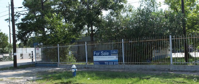
Property Detail
608 Bennington St
1352140010001
RES A BLK 1 IRIVINGTON HEIGHTS
Industrialgeneral
HARRIS
B and X Area of moderate flood hazard, usually the area between the limits of the 100-year and 500-year floods.
Texas
2025
16.08 AC
2025
North Outer Loop
220300
Houston
122,305 SF
Houston-Pasadena-The Woodlands, TX
NEARBY LISTINGS FOR SALE OR LEASE
DEMOGRAPHICS near 608 Bennington St
1 mile
3 mile
5 mile
2025 Total Population
16,003
151,895
428,196
2030 Population
17,190
163,886
462,287
Pop Growth 2025-2030
+ 7.42%
+ 7.89%
+ 7.96%
Average Age
38
38
37
2025 Total Households
5,451
56,437
168,652
HH Growth 2025-2030
+ 7.69%
+ 8.18%
+ 8.58%
Median Household Inc
$58,137
$62,799
$74,331
Avg Household Size
2.90
2.60
2.40
2025 Avg HH Vehicles
2.00
2.00
2.00
Median Home Value
$276,677
$341,384
$372,942
Median Year Built
1954
1963
1981
Nearby Places
Map Layers
Map Styles
 Street
 Aerial
Layers
 Traffic
 Biking
Places
Listings with unknown addresses are not visible on the map
- Restaurants
- Banks
- Shops
- Fitness
- Groceries
PUBLIC TRANSPORTATION
TRANSIT/SUBWAY
Melbourne / North Lindale (Redline - Harris County Metropolitan Transit Authority METRO Rail (METRORail))
Drive
Walk
Distance
Melbourne / North Lindale (Redline - Harris County Metropolitan Transit Authority METRO Rail (METRORail))
3 min
12 min
0.6 mi
COMMUTER RAIL
Drive
Walk
Distance
10 min
5.0 mi
AIRPORT
George Bush Intcntl/Houston
Drive
Walk
Distance
George Bush Intcntl/Houston
20 min
15.6 mi
William P Hobby
Drive
Walk
Distance
William P Hobby
30 min
17.8 mi
Freight Ports
Port of Houston
Drive
Walk
Distance
Port of Houston
19 min
11.6 mi
Nearby Properties
Address
Land Use
TOTAL SIZE
Lot Size
Zoning
Address
Land Use
TOTAL SIZE
Lot Size
Zoning
453,456 SF
3.11 AC
Address
Land Use
TOTAL SIZE
Lot Size
Zoning
519,374 SF
6.18 AC
Address
Land Use
TOTAL SIZE
Lot Size
Zoning
474,326 SF
43.16 AC
Address
Land Use
TOTAL SIZE
Lot Size
Zoning
314,489 SF
1.84 AC
Address
Land Use
TOTAL SIZE
Lot Size
Zoning
432,691 SF
3.26 AC
Address
Land Use
TOTAL SIZE
Lot Size
Zoning
261,312 SF
1.81 AC
Address
Land Use
TOTAL SIZE
Lot Size
Zoning
593,265 SF
3.73 AC
Address
Land Use
TOTAL SIZE
Lot Size
Zoning
379,725 SF
2.84 AC
Address
Land Use
TOTAL SIZE
Lot Size
Zoning
587,156 SF
4.40 AC
Address
Land Use
TOTAL SIZE
Lot Size
Zoning
440,577 SF
4.13 AC
Address
Land Use
TOTAL SIZE
Lot Size
Zoning
87,179 SF
4.13 AC
Address
Land Use
TOTAL SIZE
Lot Size
Zoning
263,475 SF
7.90 AC
Address
Land Use
TOTAL SIZE
Lot Size
Zoning
198,770 SF
2.10 AC
Address
Land Use
TOTAL SIZE
Lot Size
Zoning
276,332 SF
6.05 AC
Address
Land Use
TOTAL SIZE
Lot Size
Zoning
302,826 SF
2.87 AC
Address
Land Use
TOTAL SIZE
Lot Size
Zoning
545,628 SF
19.41 AC
Address
Land Use
TOTAL SIZE
Lot Size
Zoning
194,990 SF
16.36 AC
Address
Land Use
TOTAL SIZE
Lot Size
Zoning
213,548 SF
16.98 AC
Address
Land Use
TOTAL SIZE
Lot Size
Zoning
160,849 SF
2.14 AC
Address
Land Use
TOTAL SIZE
Lot Size
Zoning
105,268 SF
7.26 AC
Address
Land Use
TOTAL SIZE
Lot Size
Zoning
211,564 SF
1.20 AC
Address
Land Use
TOTAL SIZE
Lot Size
Zoning
200,511 SF
9.48 AC
Address
Land Use
TOTAL SIZE
Lot Size
Zoning
188,582 SF
17.94 AC
Address
Land Use
TOTAL SIZE
Lot Size
Zoning
64,521 SF
3.91 AC
Address
Land Use
TOTAL SIZE
Lot Size
Zoning
138,968 SF
5.34 AC
Address
Land Use
TOTAL SIZE
Lot Size
Zoning
110,721 SF
0.94 AC
Address
Land Use
TOTAL SIZE
Lot Size
Zoning
169,075 SF
11.70 AC
Address
Land Use
TOTAL SIZE
Lot Size
Zoning
66,588 SF
3.95 AC
Address
Land Use
TOTAL SIZE
Lot Size
Zoning
257,748 SF
10.70 AC
Address
Land Use
TOTAL SIZE
Lot Size
Zoning
207,101 SF
6.99 AC
The World's #1 Commercial Real Estate Marketplace
Connect with us
© 2026 CoStar Group
The information above has been obtained from sources believed reliable. While we do not doubt its accuracy we have not verified it and make no guarantee, warranty or representation about it. It is your responsibility to independently confirm its accuracy and completeness. Any projections, opinions, assumptions, or estimates used are for example only and do not represent the current or future performance of the property. The value of this transaction to you depends on tax and other factors which should be evaluated by your tax, financial, and legal advisors. You and your advisors should conduct a careful, independent investigation of the property to determine to your satisfaction the suitability of the property for your needs.