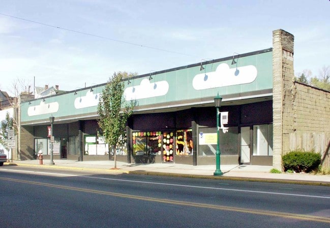
Property Record
608 Chartiers Ave, Mc Kees Rocks, PA 15136

Property Detail
608 Chartiers Ave
Pittsburgh, PA
BELL PLAN 216-218-220 IRREG LOT 60X120X56.2 RR IN ALL CHARTIERS AVE 1 STY CB BLDG - STONE FRONT (4 STO-RMS)
0043-K-00145-0000-00
ALLEGHENY
Officebuilding
Pennsylvania
AE The base floodplain where base flood elevations are provided. AE Zones are now used on new format FIRMs instead of A1-A30 Zones.
145
2024
0.16 AC
2025
West Pittsburgh
460002
Pittsburgh
NEARBY LISTINGS FOR SALE OR LEASE
DEMOGRAPHICS near 608 Chartiers Ave
1 mile
3 mile
5 mile
2025 Total Population
14,765
95,094
232,304
2030 Population
14,773
94,395
230,664
Pop Growth 2025-2030
+ 0.05%
(0.74%)
(0.71%)
Average Age
39
41
41
2025 Total Households
6,360
44,076
107,820
HH Growth 2025-2030
(0.02%)
(0.83%)
(0.73%)
Median Household Inc
$46,133
$63,168
$70,667
Avg Household Size
2.20
2.10
2.00
2025 Avg HH Vehicles
1.00
1.00
1.00
Median Home Value
$93,271
$178,307
$207,174
Median Year Built
1948
1949
1953
Nearby Places
Map Layers
Map Styles
 Street
 Aerial
Layers
 Traffic
 Biking
Places
Listings with unknown addresses are not visible on the map
- Restaurants
- Banks
- Shops
- Fitness
- Groceries
PUBLIC TRANSPORTATION
COMMUTER RAIL
Drive
Walk
Distance
10 min
4.8 mi
AIRPORT
Pittsburgh International
Drive
Walk
Distance
Pittsburgh International
28 min
13.0 mi
Arnold Palmer Regional
Drive
Walk
Distance
Arnold Palmer Regional
73 min
47.0 mi
Nearby Properties
Address
Land Use
TOTAL SIZE
Lot Size
Zoning
Address
Land Use
TOTAL SIZE
Lot Size
Zoning
10.41 AC
Address
Land Use
TOTAL SIZE
Lot Size
Zoning
13.75 AC
Address
Land Use
TOTAL SIZE
Lot Size
Zoning
26.68 AC
Address
Land Use
TOTAL SIZE
Lot Size
Zoning
Address
Land Use
TOTAL SIZE
Lot Size
Zoning
21.20 AC
Address
Land Use
TOTAL SIZE
Lot Size
Zoning
6.55 AC
Address
Land Use
TOTAL SIZE
Lot Size
Zoning
0.81 AC
Address
Land Use
TOTAL SIZE
Lot Size
Zoning
1.66 AC
Address
Land Use
TOTAL SIZE
Lot Size
Zoning
6.40 AC
Address
Land Use
TOTAL SIZE
Lot Size
Zoning
1.22 AC
Address
Land Use
TOTAL SIZE
Lot Size
Zoning
16.54 AC
Address
Land Use
TOTAL SIZE
Lot Size
Zoning
1,556 SF
36.30 AC
Address
Land Use
TOTAL SIZE
Lot Size
Zoning
Address
Land Use
TOTAL SIZE
Lot Size
Zoning
25.70 AC
Address
Land Use
TOTAL SIZE
Lot Size
Zoning
Address
Land Use
TOTAL SIZE
Lot Size
Zoning
Address
Land Use
TOTAL SIZE
Lot Size
Zoning
72.69 AC
Address
Land Use
TOTAL SIZE
Lot Size
Zoning
25.09 AC
Address
Land Use
TOTAL SIZE
Lot Size
Zoning
24.04 AC
Address
Land Use
TOTAL SIZE
Lot Size
Zoning
39.74 AC
Address
Land Use
TOTAL SIZE
Lot Size
Zoning
1.30 AC
Address
Land Use
TOTAL SIZE
Lot Size
Zoning
Address
Land Use
TOTAL SIZE
Lot Size
Zoning
3.83 AC
Address
Land Use
TOTAL SIZE
Lot Size
Zoning
13.86 AC
Address
Land Use
TOTAL SIZE
Lot Size
Zoning
Address
Land Use
TOTAL SIZE
Lot Size
Zoning
Address
Land Use
TOTAL SIZE
Lot Size
Zoning
11.93 AC
Address
Land Use
TOTAL SIZE
Lot Size
Zoning
2.51 AC
Address
Land Use
TOTAL SIZE
Lot Size
Zoning
9.18 AC
Address
Land Use
TOTAL SIZE
Lot Size
Zoning
0.92 AC
The World's #1 Commercial Real Estate Marketplace
Connect with us
© 2026 CoStar Group
The information above has been obtained from sources believed reliable. While we do not doubt its accuracy we have not verified it and make no guarantee, warranty or representation about it. It is your responsibility to independently confirm its accuracy and completeness. Any projections, opinions, assumptions, or estimates used are for example only and do not represent the current or future performance of the property. The value of this transaction to you depends on tax and other factors which should be evaluated by your tax, financial, and legal advisors. You and your advisors should conduct a careful, independent investigation of the property to determine to your satisfaction the suitability of the property for your needs.