Property Record
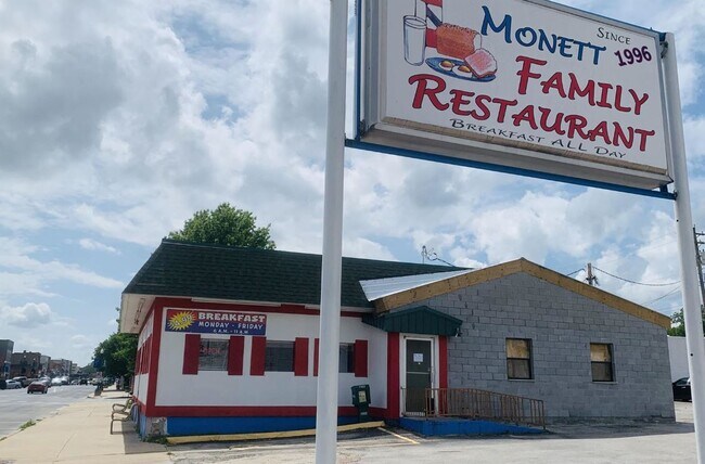
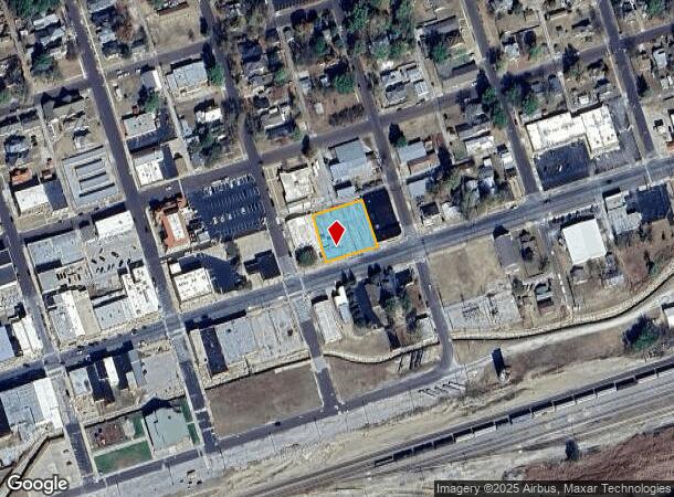
111 Northgate Ave, Monett, MO 65708

NEARBY LISTINGS FOR SALE OR LEASE
Property Detail
111 Northgate Ave
03-9.0-31-001-047-0005.000
Monett Original
Restaurantbuilding
MONETT ORIGINAL: LOTS 4 INC 9 BLK 13 : SEC:31 TWN:26 RNG:27
AE
Barry
29109C0425D
Missouri
2024
4,9,inc
2025
0.48 AC
960302
Missouri South Area
1,584 SF
Other Market Areas
DEMOGRAPHICS near 111 Northgate Ave
1 Mile
3 Mile
5 Mile
2024 Total Population
5,589
11,161
13,716
2029 Population
5,717
11,410
14,050
Pop Growth 2024-2029
+ 2.29%
+ 2.23%
+ 2.44%
Average Age
36
37
38
2024 Total Households
2,051
4,133
5,099
HH Growth 2024-2029
+ 2.15%
+ 2.08%
+ 2.31%
Median Household Inc
$43,932
$46,614
$47,427
Avg Household Size
2.60
2.60
2.60
2024 Avg HH Vehicles
2.00
2.00
2.00
Median Home Value
$90,072
$130,708
$141,404
Median Year Built
1966
1973
1974
Nearby Places
Map Layers
Map Styles
 Street
 Aerial
- Restaurants
- Banks
- Shops
- Fitness
- Groceries
PUBLIC TRANSPORTATION
AIRPORT
Springfield-Branson Ntl
DRIVE
WALK
Distance
Springfield-Branson Ntl
76 min
45.4 mi
SALE & LEASE HISTORY
LISTING DATE
SALE/LEASE

Oct 15, 2020
For Sale
Oct 12, 2021
For Sale
Apr 09, 2025
For Sale
Nearby Properties
Address
Land Use
TOTAL SIZE
Lot Size
Zoning
Address
Land Use
TOTAL SIZE
Lot Size
Zoning
6,000 SF
11.60 AC
Address
Land Use
TOTAL SIZE
Lot Size
Zoning
5.43 AC
Address
Land Use
TOTAL SIZE
Lot Size
Zoning
43,706 SF
9.08 AC
Address
Land Use
TOTAL SIZE
Lot Size
Zoning
8,648 SF
0.56 AC
Address
Land Use
TOTAL SIZE
Lot Size
Zoning
32,840 SF
1.37 AC
Address
Land Use
TOTAL SIZE
Lot Size
Zoning
7,552 SF
1.37 AC
Address
Land Use
TOTAL SIZE
Lot Size
Zoning
10,892 SF
19.60 AC
Address
Land Use
TOTAL SIZE
Lot Size
Zoning
11,400 SF
9 AC
Address
Land Use
TOTAL SIZE
Lot Size
Zoning
8,221 SF
2.50 AC
Address
Land Use
TOTAL SIZE
Lot Size
Zoning
9,136 SF
0.64 AC
Address
Land Use
TOTAL SIZE
Lot Size
Zoning
16,859 SF
1.80 AC
Address
Land Use
TOTAL SIZE
Lot Size
Zoning
55,862 SF
3.10 AC
Address
Land Use
TOTAL SIZE
Lot Size
Zoning
6,292 SF
1.20 AC
Address
Land Use
TOTAL SIZE
Lot Size
Zoning
21.33 AC
Address
Land Use
TOTAL SIZE
Lot Size
Zoning
43,800 SF
2.83 AC
Address
Land Use
TOTAL SIZE
Lot Size
Zoning
75,789 SF
5.50 AC
The World's #1 Commercial Real Estate Marketplace
Connect with us
© 2026 CoStar Group
The information above has been obtained from sources believed reliable. While we do not doubt its accuracy we have not verified it and make no guarantee, warranty or representation about it. It is your responsibility to independently confirm its accuracy and completeness. Any projections, opinions, assumptions, or estimates used are for example only and do not represent the current or future performance of the property. The value of this transaction to you depends on tax and other factors which should be evaluated by your tax, financial, and legal advisors. You and your advisors should conduct a careful, independent investigation of the property to determine to your satisfaction the suitability of the property for your needs.