Property Record
608 May Ave, Waynesboro, VA 22980
NEARBY LISTINGS FOR SALE OR LEASE
-
-
View all Waynesboro listings for sale on LoopNet.com
Property Detail
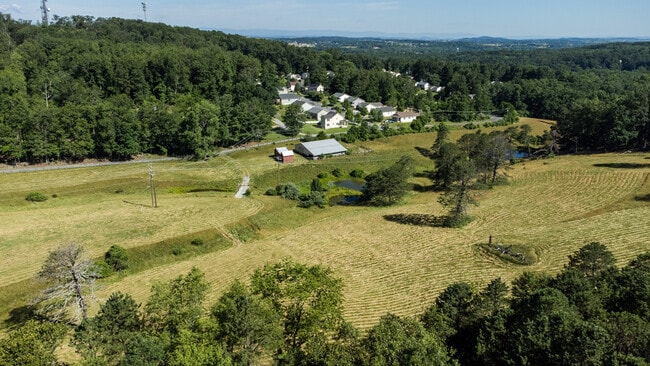
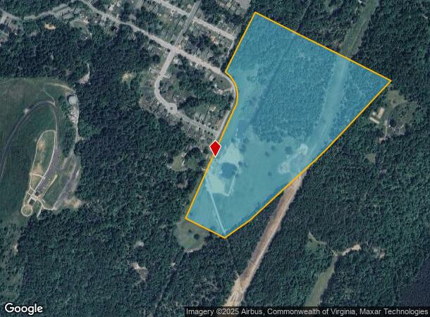
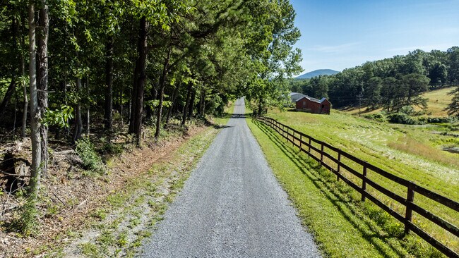
608 May Ave
48 2 - 1
46.886 ACRES ON BOTH SIDES OF MAY AVE SMALL ACREAGE
Vacantlandnec
Waynesboro
X
Virginia
51125C0050C
46.89 AC
2025
Staunton & Harrisonburg
2025
Other Market Areas
003400
Staunton-Waynesboro, VA
DEMOGRAPHICS near 608 May Ave
1 Mile
3 Mile
5 Mile
2024 Total Population
4,298
19,830
31,218
2029 Population
4,651
21,291
33,197
Pop Growth 2024-2029
+ 8.21%
+ 7.37%
+ 6.34%
Average Age
39
41
43
2024 Total Households
1,827
8,510
13,313
HH Growth 2024-2029
+ 8.21%
+ 7.36%
+ 6.36%
Median Household Inc
$34,927
$46,505
$53,503
Avg Household Size
2.30
2.30
2.30
2024 Avg HH Vehicles
2.00
2.00
2.00
Median Home Value
$144,898
$186,663
$232,799
Median Year Built
1982
1972
1977
Nearby Places
Map Layers
Map Styles
 Street
 Aerial
- Restaurants
- Banks
- Shops
- Fitness
- Groceries
PUBLIC TRANSPORTATION
AIRPORT
Charlottesville-Albemarle
DRIVE
WALK
Distance
Charlottesville-Albemarle
52 min
35.2 mi
Freight Ports
Virginia Port Authority - Richmond
DRIVE
WALK
Distance
Virginia Port Authority - Richmond
124 min
103.3 mi
SALE & LEASE HISTORY
LISTING DATE
SALE/LEASE

Jun 30, 2022
For Sale
Nearby Properties
Address
Land Use
TOTAL SIZE
Lot Size
Zoning
Address
Land Use
TOTAL SIZE
Lot Size
Zoning
150,944 SF
22.24 AC
RG-5
Address
Land Use
TOTAL SIZE
Lot Size
Zoning
165,670 SF
5.31 AC
R-O
Address
Land Use
TOTAL SIZE
Lot Size
Zoning
2.08 AC
RG-5
Address
Land Use
TOTAL SIZE
Lot Size
Zoning
48,888 SF
9.01 AC
RG-5
Address
Land Use
TOTAL SIZE
Lot Size
Zoning
121,275 SF
18.39 AC
RG-5
Address
Land Use
TOTAL SIZE
Lot Size
Zoning
947 SF
13.62 AC
RG-5
Address
Land Use
TOTAL SIZE
Lot Size
Zoning
301,338 SF
21.52 AC
H-I
Address
Land Use
TOTAL SIZE
Lot Size
Zoning
12.01 AC
RS-7
Address
Land Use
TOTAL SIZE
Lot Size
Zoning
5,624 SF
74.80 AC
H-I
Address
Land Use
TOTAL SIZE
Lot Size
Zoning
460 SF
144.09 AC
H-I
Address
Land Use
TOTAL SIZE
Lot Size
Zoning
7,512 SF
6.39 AC
R-MF
Address
Land Use
TOTAL SIZE
Lot Size
Zoning
1,844 SF
8.39 AC
R-MF
Address
Land Use
TOTAL SIZE
Lot Size
Zoning
2,460 SF
31.78 AC
PUD
Address
Land Use
TOTAL SIZE
Lot Size
Zoning
840 SF
1.70 AC
C-B
Address
Land Use
TOTAL SIZE
Lot Size
Zoning
41,574 SF
5.29 AC
H-B
Address
Land Use
TOTAL SIZE
Lot Size
Zoning
2,393 SF
6.81 AC
R-MF
Address
Land Use
TOTAL SIZE
Lot Size
Zoning
62,626 SF
1.15 AC
R-MF
Address
Land Use
TOTAL SIZE
Lot Size
Zoning
54,021 SF
9.74 AC
RS-7
Address
Land Use
TOTAL SIZE
Lot Size
Zoning
36,698 SF
0.90 AC
R-MF
Address
Land Use
TOTAL SIZE
Lot Size
Zoning
1,000 SF
4.17 AC
H-B
Address
Land Use
TOTAL SIZE
Lot Size
Zoning
42,122 SF
8 AC
RG-5
Address
Land Use
TOTAL SIZE
Lot Size
Zoning
106,752 SF
7.76 AC
H-I
Address
Land Use
TOTAL SIZE
Lot Size
Zoning
301,313 SF
55.86 AC
H-I
Address
Land Use
TOTAL SIZE
Lot Size
Zoning
18,730 SF
2.43 AC
L-I
Address
Land Use
TOTAL SIZE
Lot Size
Zoning
4,096 SF
2.24 AC
RG-5
Address
Land Use
TOTAL SIZE
Lot Size
Zoning
14,263 SF
0.48 AC
C-B
Address
Land Use
TOTAL SIZE
Lot Size
Zoning
93,866 SF
13.15 AC
H-B
Address
Land Use
TOTAL SIZE
Lot Size
Zoning
5,277 SF
11.69 AC
H-B
Address
Land Use
TOTAL SIZE
Lot Size
Zoning
89,786 SF
6 AC
MX-B
Address
Land Use
TOTAL SIZE
Lot Size
Zoning
13,641 SF
3.12 AC
R-MF
The World's #1 Commercial Real Estate Marketplace
Connect with us
© 2025 CoStar Group
The information above has been obtained from sources believed reliable. While we do not doubt its accuracy we have not verified it and make no guarantee, warranty or representation about it. It is your responsibility to independently confirm its accuracy and completeness. Any projections, opinions, assumptions, or estimates used are for example only and do not represent the current or future performance of the property. The value of this transaction to you depends on tax and other factors which should be evaluated by your tax, financial, and legal advisors. You and your advisors should conduct a careful, independent investigation of the property to determine to your satisfaction the suitability of the property for your needs.