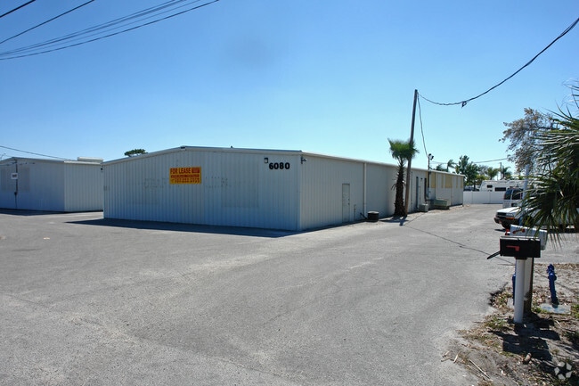
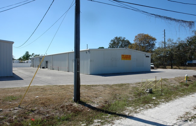
Property Record
6060 126Th Ave, Largo, FL 33773
Current Lease Availabilities
NEARBY LISTINGS FOR SALE OR LEASE
Property Detail
6060 126Th Ave
Tampa-St. Petersburg-Clearwater, FL
Pinellas Groves
08-30-16-70974-400-0502
PINELLAS GROVES SE 1/4, SEC 8-30-16 PART OF LOT 5 DESC FROM SW COR OF SD LOT 5 TH N00D0243W 1180.78FT TH S88D3359E 98.38FT TH CUR RT RAD 510FT ARC 18.95FT CB S87D3080E 18.95FT FOR POB TH CUR RT RAD 510FT ARC 119.19FT CB S79D4436E 118.89FT TH S00D0201
Warehouse
Pinellas
X
Florida
12103C0139H
5
2024
0.51 AC
2025
South Pinellas
024505
Tampa/St Petersburg
8,805 SF
DEMOGRAPHICS near 6060 126Th Ave
1 Mile
3 Mile
5 Mile
2024 Total Population
5,548
77,702
229,459
2029 Population
5,633
77,712
230,993
Pop Growth 2024-2029
+ 1.53%
+ 0.01%
+ 0.67%
Average Age
44
45
46
2024 Total Households
2,499
34,650
106,090
HH Growth 2024-2029
+ 1.80%
(0.08%)
+ 0.57%
Median Household Inc
$51,165
$55,644
$57,064
Avg Household Size
2.10
2.10
2.10
2024 Avg HH Vehicles
1.00
2.00
2.00
Median Home Value
$172,641
$212,637
$216,631
Median Year Built
1986
1979
1977
Nearby Places
- Restaurants
- Banks
- Shops
- Fitness
- Groceries
PUBLIC TRANSPORTATION
AIRPORT
St Pete-Clearwater International
DRIVE
WALK
Distance
St Pete-Clearwater International
16 min
5.9 mi
Tampa International
DRIVE
WALK
Distance
Tampa International
27 min
16.9 mi
Freight Ports
Port of Tampa Bay
DRIVE
WALK
Distance
Port of Tampa Bay
37 min
22.3 mi
Nearby Properties
Address
Land Use
TOTAL SIZE
Lot Size
Zoning
Address
Land Use
TOTAL SIZE
Lot Size
Zoning
795,890 SF
69.11 AC
M1
Address
Land Use
TOTAL SIZE
Lot Size
Zoning
130,544 SF
1,313.50 AC
PCAIRPOR
Address
Land Use
TOTAL SIZE
Lot Size
Zoning
1,232,878 SF
12.64 AC
Address
Land Use
TOTAL SIZE
Lot Size
Zoning
372,013 SF
10.10 AC
Address
Land Use
TOTAL SIZE
Lot Size
Zoning
171,420 SF
300.24 AC
M1
Address
Land Use
TOTAL SIZE
Lot Size
Zoning
367,411 SF
16.12 AC
Address
Land Use
TOTAL SIZE
Lot Size
Zoning
382,389 SF
13.62 AC
Address
Land Use
TOTAL SIZE
Lot Size
Zoning
358,681 SF
11.70 AC
Address
Land Use
TOTAL SIZE
Lot Size
Zoning
337,954 SF
21 AC
R3
Address
Land Use
TOTAL SIZE
Lot Size
Zoning
402,681 SF
18.40 AC
Address
Land Use
TOTAL SIZE
Lot Size
Zoning
255,548 SF
21.69 AC
RPD10
Address
Land Use
TOTAL SIZE
Lot Size
Zoning
364,675 SF
66.40 AC
AE
Address
Land Use
TOTAL SIZE
Lot Size
Zoning
311,000 SF
15.50 AC
Address
Land Use
TOTAL SIZE
Lot Size
Zoning
384,124 SF
25.78 AC
C3
Address
Land Use
TOTAL SIZE
Lot Size
Zoning
446,556 SF
14.95 AC
M1
Address
Land Use
TOTAL SIZE
Lot Size
Zoning
396,822 SF
36.20 AC
RPD5
Address
Land Use
TOTAL SIZE
Lot Size
Zoning
362,618 SF
40.19 AC
R6
Address
Land Use
TOTAL SIZE
Lot Size
Zoning
266,396 SF
23.18 AC
Address
Land Use
TOTAL SIZE
Lot Size
Zoning
294,478 SF
44.79 AC
M1
Address
Land Use
TOTAL SIZE
Lot Size
Zoning
352,158 SF
47.45 AC
Address
Land Use
TOTAL SIZE
Lot Size
Zoning
160,014 SF
7.77 AC
Address
Land Use
TOTAL SIZE
Lot Size
Zoning
206,685 SF
16.75 AC
RPD5
Address
Land Use
TOTAL SIZE
Lot Size
Zoning
267,649 SF
17.86 AC
Address
Land Use
TOTAL SIZE
Lot Size
Zoning
582,271 SF
17.14 AC
Address
Land Use
TOTAL SIZE
Lot Size
Zoning
225,515 SF
26.82 AC
Address
Land Use
TOTAL SIZE
Lot Size
Zoning
249,699 SF
15 AC
Address
Land Use
TOTAL SIZE
Lot Size
Zoning
280,129 SF
Address
Land Use
TOTAL SIZE
Lot Size
Zoning
296,868 SF
20.99 AC
Address
Land Use
TOTAL SIZE
Lot Size
Zoning
159,073 SF
3.02 AC
Address
Land Use
TOTAL SIZE
Lot Size
Zoning
222,575 SF
15.03 AC
R3
The World's #1 Commercial Real Estate Marketplace
Connect with us
© 2025 CoStar Group
The information above has been obtained from sources believed reliable. While we do not doubt its accuracy we have not verified it and make no guarantee, warranty or representation about it. It is your responsibility to independently confirm its accuracy and completeness. Any projections, opinions, assumptions, or estimates used are for example only and do not represent the current or future performance of the property. The value of this transaction to you depends on tax and other factors which should be evaluated by your tax, financial, and legal advisors. You and your advisors should conduct a careful, independent investigation of the property to determine to your satisfaction the suitability of the property for your needs.