Property Record
6080 Mobile Hwy, Montgomery, AL 36105

NEARBY LISTINGS FOR SALE OR LEASE
-
-
No Photo
-
View all Montgomery listings for lease on LoopNet.com
Property Detail
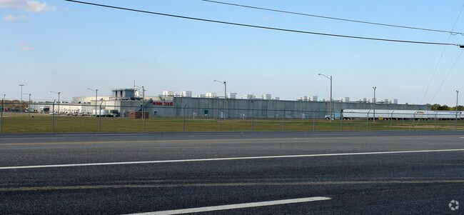
6080 Mobile Hwy
Montgomery, AL
Mobile Highway Logistics Park
14-02-10-2-001-003.001
1402102001003001
Publicstorage
Montgomery
X
Alabama
01101C0211J
1
2025
114.39 AC
2025
South Montgomery
005904
Montgomery
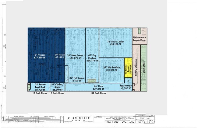
403,088 SF
DEMOGRAPHICS near 6080 Mobile Hwy
1 Mile
3 Mile
5 Mile
2024 Total Population
1,549
6,463
33,478
2029 Population
1,513
6,334
33,499
Pop Growth 2024-2029
(2.32%)
(2.00%)
+ 0.06%
Average Age
43
42
40
2024 Total Households
615
2,568
13,734
HH Growth 2024-2029
(2.44%)
(1.99%)
+ 0.13%
Median Household Inc
$29,014
$31,241
$30,955
Avg Household Size
2.40
2.50
2.30
2024 Avg HH Vehicles
2.00
2.00
2.00
Median Home Value
$61,403
$81,008
$72,452
Median Year Built
1971
1973
1965
Nearby Places
Map Layers
Map Styles
 Street
 Aerial
- Restaurants
- Banks
- Shops
- Fitness
- Groceries
PUBLIC TRANSPORTATION
AIRPORT
Montgomery Regional (Dannelly Field)
DRIVE
WALK
Distance
Montgomery Regional (Dannelly Field)
8 min
4.7 mi
Freight Ports
Port of Mobile
DRIVE
WALK
Distance
Port of Mobile
176 min
161.5 mi
SALE & LEASE HISTORY
LISTING DATE
SALE/LEASE

Jul 16, 2021
For Lease
Apr 23, 2019
For Lease
Nearby Properties
Address
Land Use
TOTAL SIZE
Lot Size
Zoning
Address
Land Use
TOTAL SIZE
Lot Size
Zoning
909,718 SF
310.14 AC
M-3
Address
Land Use
TOTAL SIZE
Lot Size
Zoning
21,991 SF
100.36 AC
M-3
Address
Land Use
TOTAL SIZE
Lot Size
Zoning
858,004 SF
61.22 AC
M-1
Address
Land Use
TOTAL SIZE
Lot Size
Zoning
3,670 SF
239.11 AC
Address
Land Use
TOTAL SIZE
Lot Size
Zoning
657,684 SF
59 AC
M-1
Address
Land Use
TOTAL SIZE
Lot Size
Zoning
37,700 SF
Address
Land Use
TOTAL SIZE
Lot Size
Zoning
9,060 SF
524.11 AC
Address
Land Use
TOTAL SIZE
Lot Size
Zoning
189 SF
42 AC
Address
Land Use
TOTAL SIZE
Lot Size
Zoning
250,600 SF
41.59 AC
M-1
Address
Land Use
TOTAL SIZE
Lot Size
Zoning
189,246 SF
16.79 AC
M-3
Address
Land Use
TOTAL SIZE
Lot Size
Zoning
407,491 SF
37.98 AC
M-1
Address
Land Use
TOTAL SIZE
Lot Size
Zoning
391,901 SF
13 AC
M-3
Address
Land Use
TOTAL SIZE
Lot Size
Zoning
482.36 AC
AGR-1
Address
Land Use
TOTAL SIZE
Lot Size
Zoning
93,745 SF
16 AC
B-4
Address
Land Use
TOTAL SIZE
Lot Size
Zoning
200,012 SF
12.39 AC
M-1
Address
Land Use
TOTAL SIZE
Lot Size
Zoning
213,941 SF
28 AC
M-1
Address
Land Use
TOTAL SIZE
Lot Size
Zoning
16,016 SF
30 AC
AGR-1
Address
Land Use
TOTAL SIZE
Lot Size
Zoning
240,744 SF
22 AC
M-1
Address
Land Use
TOTAL SIZE
Lot Size
Zoning
63,046 SF
2.85 AC
M-1
Address
Land Use
TOTAL SIZE
Lot Size
Zoning
396 SF
312.19 AC
AGR-1
Address
Land Use
TOTAL SIZE
Lot Size
Zoning
129,122 SF
9.60 AC
M-3
Address
Land Use
TOTAL SIZE
Lot Size
Zoning
96,162 SF
20 AC
M-1
Address
Land Use
TOTAL SIZE
Lot Size
Zoning
271.07 AC
AGR-1
Address
Land Use
TOTAL SIZE
Lot Size
Zoning
176,106 SF
19.22 AC
M-3
Address
Land Use
TOTAL SIZE
Lot Size
Zoning
8,483 SF
18.66 AC
M-1
Address
Land Use
TOTAL SIZE
Lot Size
Zoning
287,509 SF
32.30 AC
M-1
Address
Land Use
TOTAL SIZE
Lot Size
Zoning
154,853 SF
14.67 AC
M-1
Address
Land Use
TOTAL SIZE
Lot Size
Zoning
52,355 SF
2.19 AC
B-2
Address
Land Use
TOTAL SIZE
Lot Size
Zoning
114,714 SF
24.60 AC
M-1
The World's #1 Commercial Real Estate Marketplace
Connect with us
© 2026 CoStar Group
The information above has been obtained from sources believed reliable. While we do not doubt its accuracy we have not verified it and make no guarantee, warranty or representation about it. It is your responsibility to independently confirm its accuracy and completeness. Any projections, opinions, assumptions, or estimates used are for example only and do not represent the current or future performance of the property. The value of this transaction to you depends on tax and other factors which should be evaluated by your tax, financial, and legal advisors. You and your advisors should conduct a careful, independent investigation of the property to determine to your satisfaction the suitability of the property for your needs.