Property Record
6080 Range Land Rd, Reno, NV 89510
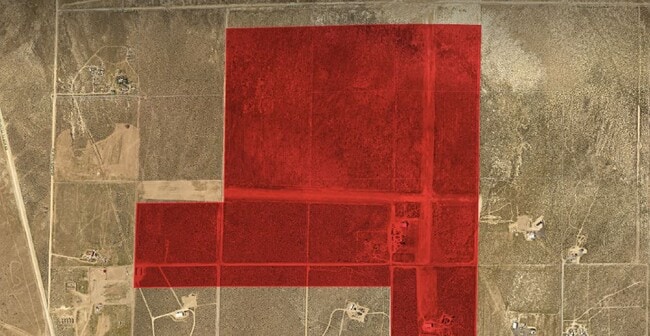
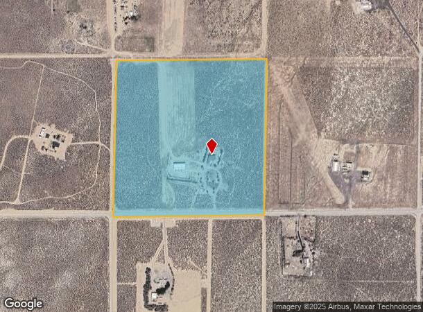
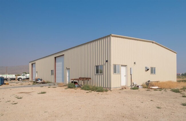
This Property Is For Sale
NEARBY LISTINGS FOR SALE OR LEASE
-
-
View all Reno listings for sale on LoopNet.com
Property Detail
6080 Range Land Rd
Reno, NV
_Unspecified
076-210-07
Washoe
Sfr
Nevada
X
40.84 AC
32031C2675G
N Outlying Washoe County
2,033 SF
Reno/Sparks
DEMOGRAPHICS near 6080 Range Land Rd
1 Mile
3 Mile
5 Mile
2024 Total Population
69
464
843
2029 Population
77
513
932
Pop Growth 2024-2029
+ 11.59%
+ 10.56%
+ 10.56%
Average Age
45
45
45
2024 Total Households
25
164
298
HH Growth 2024-2029
+ 8.00%
+ 10.98%
+ 10.74%
Median Household Inc
$96,874
$97,499
$97,272
Avg Household Size
2.70
2.60
2.60
2024 Avg HH Vehicles
3.00
3.00
3.00
Median Home Value
$696,428
$682,795
$684,911
Median Year Built
1998
1998
1998
Nearby Places
Map Layers
Map Styles
 Street
 Aerial
- Restaurants
- Banks
- Shops
- Fitness
- Groceries
PUBLIC TRANSPORTATION
AIRPORT
Reno/Tahoe International
DRIVE
WALK
Distance
Reno/Tahoe International
58 min
29.7 mi
Freight Ports
Port of Stockton
DRIVE
WALK
Distance
Port of Stockton
243 min
204.0 mi
Nearby Properties
Address
Land Use
TOTAL SIZE
Lot Size
Zoning
Address
Land Use
TOTAL SIZE
Lot Size
Zoning
75,629 SF
38.78 AC
NC 14% / M
Address
Land Use
TOTAL SIZE
Lot Size
Zoning
1,440 SF
148.15 AC
PSP
Address
Land Use
TOTAL SIZE
Lot Size
Zoning
1,600 SF
530.22 AC
PR
Address
Land Use
TOTAL SIZE
Lot Size
Zoning
7,200 SF
240 AC
GR
Address
Land Use
TOTAL SIZE
Lot Size
Zoning
3,528 SF
2.14 AC
NC
Address
Land Use
TOTAL SIZE
Lot Size
Zoning
554.22 AC
PSP 2% /
Address
Land Use
TOTAL SIZE
Lot Size
Zoning
5,000 SF
40.66 AC
GRA
Address
Land Use
TOTAL SIZE
Lot Size
Zoning
3,200 SF
72.86 AC
GRA
Address
Land Use
TOTAL SIZE
Lot Size
Zoning
152 AC
GRA
Address
Land Use
TOTAL SIZE
Lot Size
Zoning
1,152 SF
41.86 AC
GRA
Address
Land Use
TOTAL SIZE
Lot Size
Zoning
64.91 AC
GRA
Address
Land Use
TOTAL SIZE
Lot Size
Zoning
67.92 AC
GRA
Address
Land Use
TOTAL SIZE
Lot Size
Zoning
72.28 AC
GRA
Address
Land Use
TOTAL SIZE
Lot Size
Zoning
59.87 AC
GRA
Address
Land Use
TOTAL SIZE
Lot Size
Zoning
42.25 AC
GRA
Address
Land Use
TOTAL SIZE
Lot Size
Zoning
66.45 AC
GRA
Address
Land Use
TOTAL SIZE
Lot Size
Zoning
45.81 AC
GRA
Address
Land Use
TOTAL SIZE
Lot Size
Zoning
57.05 AC
GRA
Address
Land Use
TOTAL SIZE
Lot Size
Zoning
42.59 AC
GRA
Address
Land Use
TOTAL SIZE
Lot Size
Zoning
80 AC
GR
Address
Land Use
TOTAL SIZE
Lot Size
Zoning
45.57 AC
NC 85% / G
Address
Land Use
TOTAL SIZE
Lot Size
Zoning
45.45 AC
NC 32% / M
Address
Land Use
TOTAL SIZE
Lot Size
Zoning
198.13 AC
GRA
Address
Land Use
TOTAL SIZE
Lot Size
Zoning
40.72 AC
GRA
Address
Land Use
TOTAL SIZE
Lot Size
Zoning
40.91 AC
GRA
Address
Land Use
TOTAL SIZE
Lot Size
Zoning
40.93 AC
GRA
Address
Land Use
TOTAL SIZE
Lot Size
Zoning
41.80 AC
GRA
Address
Land Use
TOTAL SIZE
Lot Size
Zoning
41.80 AC
GRA
Address
Land Use
TOTAL SIZE
Lot Size
Zoning
40.87 AC
GRA
Address
Land Use
TOTAL SIZE
Lot Size
Zoning
69.33 AC
GRA
The World's #1 Commercial Real Estate Marketplace
Connect with us
© 2026 CoStar Group
The information above has been obtained from sources believed reliable. While we do not doubt its accuracy we have not verified it and make no guarantee, warranty or representation about it. It is your responsibility to independently confirm its accuracy and completeness. Any projections, opinions, assumptions, or estimates used are for example only and do not represent the current or future performance of the property. The value of this transaction to you depends on tax and other factors which should be evaluated by your tax, financial, and legal advisors. You and your advisors should conduct a careful, independent investigation of the property to determine to your satisfaction the suitability of the property for your needs.