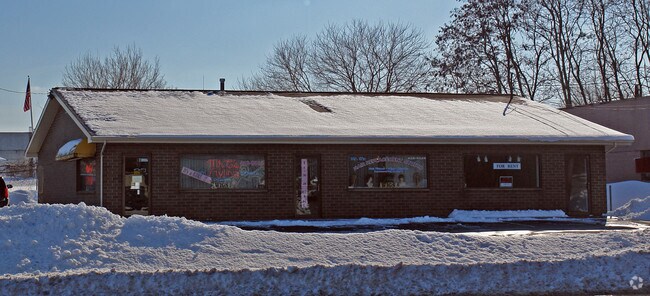
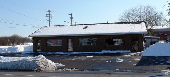
Property Record
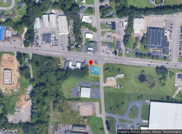
6088 E Taft Rd, Syracuse, NY 13212
NEARBY LISTINGS FOR SALE OR LEASE
Property Detail
6088 E Taft Rd
312289-057-000-0002-017-001-0000
Onondaga
Storesoffices
New York
X
17.001
36067C0226F
0.27 AC
2025
SE Outer Onondaga County
2024
Syracuse
010600
Syracuse, NY
2,440 SF
DEMOGRAPHICS near 6088 E Taft Rd
1 Mile
3 Mile
5 Mile
2024 Total Population
2,165
26,904
120,915
2029 Population
2,095
26,196
117,356
Pop Growth 2024-2029
(3.23%)
(2.63%)
(2.94%)
Average Age
44
43
41
2024 Total Households
966
11,759
51,333
HH Growth 2024-2029
(3.31%)
(2.83%)
(3.10%)
Median Household Inc
$64,091
$68,943
$63,475
Avg Household Size
2.20
2.20
2.30
2024 Avg HH Vehicles
2.00
2.00
2.00
Median Home Value
$149,910
$149,815
$150,132
Median Year Built
1955
1958
1958
Nearby Places
Map Layers
Map Styles
 Street
 Aerial
- Restaurants
- Banks
- Shops
- Fitness
- Groceries
PUBLIC TRANSPORTATION
COMMUTER RAIL
DRIVE
WALK
Distance
12 min
6.8 mi
DRIVE
WALK
Distance
12 min
6.8 mi
AIRPORT
Syracuse Hancock International
DRIVE
WALK
Distance
Syracuse Hancock International
10 min
3.9 mi
Nearby Properties
Address
Land Use
TOTAL SIZE
Lot Size
Zoning
Address
Land Use
TOTAL SIZE
Lot Size
Zoning
569,463 SF
94.77 AC
06 - INDUS
Address
Land Use
TOTAL SIZE
Lot Size
Zoning
80,845 SF
14.04 AC
06 - INDUS
Address
Land Use
TOTAL SIZE
Lot Size
Zoning
116,580 SF
18.46 AC
06 - INDUS
Address
Land Use
TOTAL SIZE
Lot Size
Zoning
439,670 SF
74.73 AC
C-G
Address
Land Use
TOTAL SIZE
Lot Size
Zoning
22.16 AC
06 - INDUS
Address
Land Use
TOTAL SIZE
Lot Size
Zoning
157,010 SF
36.98 AC
Address
Land Use
TOTAL SIZE
Lot Size
Zoning
11,484 SF
16.36 AC
03 - MULTI
Address
Land Use
TOTAL SIZE
Lot Size
Zoning
157,497 SF
14.56 AC
06 - INDUS
Address
Land Use
TOTAL SIZE
Lot Size
Zoning
110,105 SF
26.68 AC
06 - INDUS
Address
Land Use
TOTAL SIZE
Lot Size
Zoning
89,985 SF
11.37 AC
06 - INDUS
Address
Land Use
TOTAL SIZE
Lot Size
Zoning
218,439 SF
18.85 AC
Address
Land Use
TOTAL SIZE
Lot Size
Zoning
2,025 SF
267.94 AC
06 - INDUS
Address
Land Use
TOTAL SIZE
Lot Size
Zoning
165,954 SF
10.66 AC
06 - INDUS
Address
Land Use
TOTAL SIZE
Lot Size
Zoning
246,172 SF
16.65 AC
Address
Land Use
TOTAL SIZE
Lot Size
Zoning
32,840 SF
26.60 AC
05 - COMME
Address
Land Use
TOTAL SIZE
Lot Size
Zoning
110,811 SF
11.46 AC
06 - INDUS
Address
Land Use
TOTAL SIZE
Lot Size
Zoning
203,345 SF
18.17 AC
Address
Land Use
TOTAL SIZE
Lot Size
Zoning
84,048 SF
19.42 AC
Address
Land Use
TOTAL SIZE
Lot Size
Zoning
70,668 SF
5.35 AC
05 - COMME
Address
Land Use
TOTAL SIZE
Lot Size
Zoning
169,511 SF
4.25 AC
01 - NOT Z
Address
Land Use
TOTAL SIZE
Lot Size
Zoning
206,807 SF
46 AC
06 - INDUS
Address
Land Use
TOTAL SIZE
Lot Size
Zoning
125,400 SF
18.11 AC
GC
Address
Land Use
TOTAL SIZE
Lot Size
Zoning
125,684 SF
25.61 AC
06 - INDUS
Address
Land Use
TOTAL SIZE
Lot Size
Zoning
92,538 SF
19.96 AC
06 - INDUS
Address
Land Use
TOTAL SIZE
Lot Size
Zoning
120,068 SF
9.26 AC
GCPLUS
Address
Land Use
TOTAL SIZE
Lot Size
Zoning
141,472 SF
12.38 AC
C-G
Address
Land Use
TOTAL SIZE
Lot Size
Zoning
92,844 SF
14.26 AC
C-G
Address
Land Use
TOTAL SIZE
Lot Size
Zoning
296.49 AC
06 - INDUS
Address
Land Use
TOTAL SIZE
Lot Size
Zoning
115,096 SF
10.29 AC
06 - INDUS
The World's #1 Commercial Real Estate Marketplace
Connect with us
© 2026 CoStar Group
The information above has been obtained from sources believed reliable. While we do not doubt its accuracy we have not verified it and make no guarantee, warranty or representation about it. It is your responsibility to independently confirm its accuracy and completeness. Any projections, opinions, assumptions, or estimates used are for example only and do not represent the current or future performance of the property. The value of this transaction to you depends on tax and other factors which should be evaluated by your tax, financial, and legal advisors. You and your advisors should conduct a careful, independent investigation of the property to determine to your satisfaction the suitability of the property for your needs.