Property Record
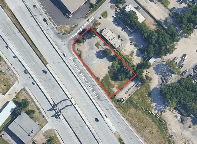
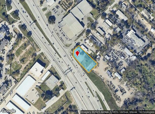
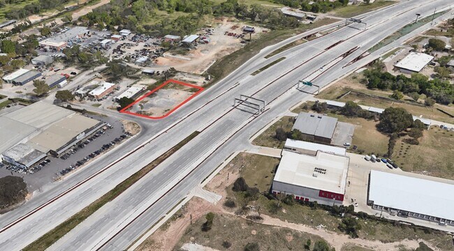
609 Bastrop Hwy N, Austin, TX 78741
Current Lease Availabilities
NEARBY LISTINGS FOR SALE OR LEASE
Property Detail
609 Bastrop Hwy N
Austin-Round Rock, TX
Commerce Square
287042
LOT 1 * LESS .879A COMMERCE SQUARE
Vacantlandnec
Travis
AE
Texas
48453C0610L
1
2024
1.16 AC
2025
Southeast
002310
Austin
1,920 SF
DEMOGRAPHICS near 609 Bastrop Hwy N
1 Mile
3 Mile
5 Mile
2024 Total Population
5,795
82,210
243,259
2029 Population
6,417
90,635
266,871
Pop Growth 2024-2029
+ 10.73%
+ 10.25%
+ 9.71%
Average Age
36
34
35
2024 Total Households
1,945
36,002
104,139
HH Growth 2024-2029
+ 11.98%
+ 10.92%
+ 10.88%
Median Household Inc
$35,034
$60,540
$74,774
Avg Household Size
2.70
2.20
2.10
2024 Avg HH Vehicles
2.00
2.00
2.00
Median Home Value
$260,824
$411,173
$488,752
Median Year Built
1994
2000
2002
Nearby Places
Map Layers
Map Styles
 Street
 Aerial
- Restaurants
- Banks
- Shops
- Fitness
- Groceries
PUBLIC TRANSPORTATION
COMMUTER RAIL
Austin (Texas Eagle - Amtrak)
DRIVE
WALK
Distance
Austin (Texas Eagle - Amtrak)
11 min
5.6 mi
AIRPORT
Austin-Bergstrom International
DRIVE
WALK
Distance
Austin-Bergstrom International
16 min
8.0 mi
Freight Ports
Calhoun Port
DRIVE
WALK
Distance
Calhoun Port
182 min
151.5 mi
Nearby Properties
Address
Land Use
TOTAL SIZE
Lot Size
Zoning
Address
Land Use
TOTAL SIZE
Lot Size
Zoning
9,768 SF
386.80 AC
Address
Land Use
TOTAL SIZE
Lot Size
Zoning
999,200 SF
25 AC
Address
Land Use
TOTAL SIZE
Lot Size
Zoning
832,892 SF
30.12 AC
Address
Land Use
TOTAL SIZE
Lot Size
Zoning
356,147 SF
10.48 AC
Address
Land Use
TOTAL SIZE
Lot Size
Zoning
492,715 SF
9.22 AC
Address
Land Use
TOTAL SIZE
Lot Size
Zoning
91,836 SF
19.80 AC
Address
Land Use
TOTAL SIZE
Lot Size
Zoning
307,610 SF
8.95 AC
Address
Land Use
TOTAL SIZE
Lot Size
Zoning
387,267 SF
3.25 AC
Address
Land Use
TOTAL SIZE
Lot Size
Zoning
300,883 SF
3.47 AC
Address
Land Use
TOTAL SIZE
Lot Size
Zoning
91,639 SF
35.97 AC
Address
Land Use
TOTAL SIZE
Lot Size
Zoning
558,324 SF
45.12 AC
Address
Land Use
TOTAL SIZE
Lot Size
Zoning
4,944 SF
25.09 AC
Address
Land Use
TOTAL SIZE
Lot Size
Zoning
255,483 SF
35 AC
Address
Land Use
TOTAL SIZE
Lot Size
Zoning
190,546 SF
5.85 AC
Address
Land Use
TOTAL SIZE
Lot Size
Zoning
301,125 SF
5.23 AC
Address
Land Use
TOTAL SIZE
Lot Size
Zoning
31,357 SF
37.73 AC
Address
Land Use
TOTAL SIZE
Lot Size
Zoning
255,790 SF
4.34 AC
Address
Land Use
TOTAL SIZE
Lot Size
Zoning
236,503 SF
6.86 AC
Address
Land Use
TOTAL SIZE
Lot Size
Zoning
19.76 AC
Address
Land Use
TOTAL SIZE
Lot Size
Zoning
272,084 SF
3.87 AC
Address
Land Use
TOTAL SIZE
Lot Size
Zoning
300,300 SF
3.72 AC
Address
Land Use
TOTAL SIZE
Lot Size
Zoning
266,871 SF
9.13 AC
Address
Land Use
TOTAL SIZE
Lot Size
Zoning
264,897 SF
2.54 AC
Address
Land Use
TOTAL SIZE
Lot Size
Zoning
84,920 SF
74.13 AC
Address
Land Use
TOTAL SIZE
Lot Size
Zoning
279,539 SF
3.99 AC
Address
Land Use
TOTAL SIZE
Lot Size
Zoning
297,552 SF
15.93 AC
Address
Land Use
TOTAL SIZE
Lot Size
Zoning
215,109 SF
4.09 AC
Address
Land Use
TOTAL SIZE
Lot Size
Zoning
193,788 SF
107.16 AC
Address
Land Use
TOTAL SIZE
Lot Size
Zoning
270,688 SF
8.37 AC
Address
Land Use
TOTAL SIZE
Lot Size
Zoning
206,608 SF
10.61 AC
The World's #1 Commercial Real Estate Marketplace
Connect with us
© 2025 CoStar Group
The information above has been obtained from sources believed reliable. While we do not doubt its accuracy we have not verified it and make no guarantee, warranty or representation about it. It is your responsibility to independently confirm its accuracy and completeness. Any projections, opinions, assumptions, or estimates used are for example only and do not represent the current or future performance of the property. The value of this transaction to you depends on tax and other factors which should be evaluated by your tax, financial, and legal advisors. You and your advisors should conduct a careful, independent investigation of the property to determine to your satisfaction the suitability of the property for your needs.