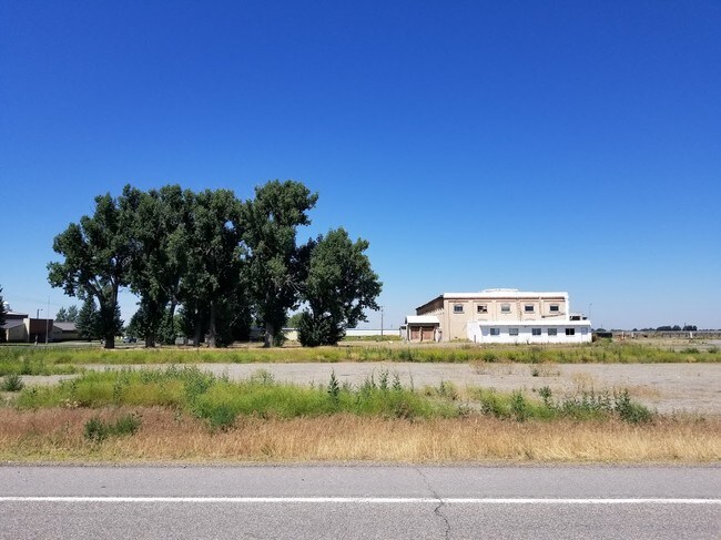
Property Record
609 E 3Rd N, Sugar City, ID 83448


Save to a Folder
{{folder.Name}}
{{folder.ListingIds.length}} Properties
{{folder.ListingIds.length}} Property
Create a New Folder
Property Detail
609 E 3Rd N
Rexburg, ID
SUGAR CITY ACREAGE TAX 5560 LESS TAX 6714 06N40E SEC 4
RPS6N40E042391
MADISON
Commercialnec
Idaho
2025
7.91 AC
2025
Idaho South Area
950102
Other Market Areas
23,660 SF
NEARBY LISTINGS FOR SALE OR LEASE
DEMOGRAPHICS near 609 E 3Rd N
1 mile
3 mile
5 mile
2025 Total Population
1,956
4,595
34,299
2030 Population
2,042
4,823
35,523
Pop Growth 2025-2030
+ 4.40%
+ 4.96%
+ 3.57%
Average Age
35
34
28
2025 Total Households
572
1,313
7,596
HH Growth 2025-2030
+ 4.72%
+ 5.33%
+ 4.29%
Median Household Inc
$80,275
$79,331
$62,491
Avg Household Size
3.40
3.30
3.00
2025 Avg HH Vehicles
2.00
2.00
2.00
Median Home Value
$377,238
$400,725
$394,629
Median Year Built
1997
2000
1997
Nearby Places
Map Layers
Map Styles
 Street
 Aerial
Layers
 Traffic
 Biking
Places
Listings with unknown addresses are not visible on the map
- Restaurants
- Banks
- Shops
- Fitness
- Groceries
SALE & LEASE HISTORY
LISTING DATE
SALE/LEASE

Sep 22, 2020
For Lease
Sep 06, 2018
For Sale
Dec 21, 2023
For Lease
Nearby Properties
Address
Land Use
TOTAL SIZE
Lot Size
Zoning
Address
Land Use
TOTAL SIZE
Lot Size
Zoning
194,411 SF
17.15 AC
RBC
Address
Land Use
TOTAL SIZE
Lot Size
Zoning
75,612 SF
4.05 AC
MDR1
Address
Land Use
TOTAL SIZE
Lot Size
Zoning
10 AC
SUGAR
Address
Land Use
TOTAL SIZE
Lot Size
Zoning
30.46 AC
LI
Address
Land Use
TOTAL SIZE
Lot Size
Zoning
95,320 SF
5.25 AC
LI
Address
Land Use
TOTAL SIZE
Lot Size
Zoning
20,780 SF
1.93 AC
CBC
Address
Land Use
TOTAL SIZE
Lot Size
Zoning
30,675 SF
1 AC
LI
Address
Land Use
TOTAL SIZE
Lot Size
Zoning
50,000 SF
9.97 AC
SUGAR
Address
Land Use
TOTAL SIZE
Lot Size
Zoning
1.74 AC
CBC
Address
Land Use
TOTAL SIZE
Lot Size
Zoning
2,589 SF
1.33 AC
RBC
Address
Land Use
TOTAL SIZE
Lot Size
Zoning
11,959 SF
1.16 AC
Address
Land Use
TOTAL SIZE
Lot Size
Zoning
15,500 SF
5.94 AC
SUGAR
Address
Land Use
TOTAL SIZE
Lot Size
Zoning
16,368 SF
0.89 AC
LI
Address
Land Use
TOTAL SIZE
Lot Size
Zoning
2,927 SF
0.69 AC
CBC
Address
Land Use
TOTAL SIZE
Lot Size
Zoning
3,370 SF
0.41 AC
Address
Land Use
TOTAL SIZE
Lot Size
Zoning
46,863 SF
4.24 AC
Address
Land Use
TOTAL SIZE
Lot Size
Zoning
5.16 AC
Address
Land Use
TOTAL SIZE
Lot Size
Zoning
8,678 SF
0.50 AC
CBC
Address
Land Use
TOTAL SIZE
Lot Size
Zoning
4,252 SF
0.42 AC
CBC
Address
Land Use
TOTAL SIZE
Lot Size
Zoning
2,676 SF
0.74 AC
CBC
Address
Land Use
TOTAL SIZE
Lot Size
Zoning
6,872 SF
3 AC
CBC
Address
Land Use
TOTAL SIZE
Lot Size
Zoning
4,880 SF
0.42 AC
CBC
Address
Land Use
TOTAL SIZE
Lot Size
Zoning
24,240 SF
4.71 AC
Address
Land Use
TOTAL SIZE
Lot Size
Zoning
12,584 SF
5 AC
SUGAR
Address
Land Use
TOTAL SIZE
Lot Size
Zoning
1.32 AC
RBC
Address
Land Use
TOTAL SIZE
Lot Size
Zoning
48,400 SF
5.78 AC
LI
Address
Land Use
TOTAL SIZE
Lot Size
Zoning
5,300 SF
7.58 AC
Address
Land Use
TOTAL SIZE
Lot Size
Zoning
25,950 SF
4.65 AC
Address
Land Use
TOTAL SIZE
Lot Size
Zoning
1,400 SF
2.69 AC
I-L
The World's #1 Commercial Real Estate Marketplace
Connect with us
© 2026 CoStar Group
The information above has been obtained from sources believed reliable. While we do not doubt its accuracy we have not verified it and make no guarantee, warranty or representation about it. It is your responsibility to independently confirm its accuracy and completeness. Any projections, opinions, assumptions, or estimates used are for example only and do not represent the current or future performance of the property. The value of this transaction to you depends on tax and other factors which should be evaluated by your tax, financial, and legal advisors. You and your advisors should conduct a careful, independent investigation of the property to determine to your satisfaction the suitability of the property for your needs.