Property Record
609 International Blvd, Rock Tavern, NY 12575
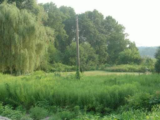
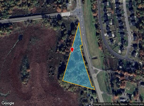
This Property Is For Sale
NEARBY LISTINGS FOR SALE OR LEASE
Property Detail
609 International Blvd
New York-Jersey City-White Plains, NY-NJ
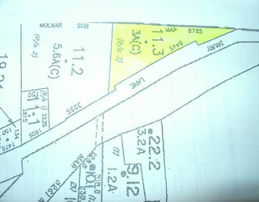
Subdivision Lands Estvan Molnar & Elizab
334600-089-000-0001-011.300-0000
Orange
Sfr
New York
A
3 AC
36071C0120E
Newburgh
934 SF
Northern New Jersey
DEMOGRAPHICS near 609 International Blvd
1 Mile
3 Mile
5 Mile
2024 Total Population
1,045
13,634
48,404
2029 Population
1,068
13,980
49,430
Pop Growth 2024-2029
+ 2.20%
+ 2.54%
+ 2.12%
Average Age
42
41
40
2024 Total Households
378
5,028
17,343
HH Growth 2024-2029
+ 2.38%
+ 2.67%
+ 2.18%
Median Household Inc
$72,580
$97,295
$93,002
Avg Household Size
2.60
2.60
2.70
2024 Avg HH Vehicles
2.00
2.00
2.00
Median Home Value
$264,583
$297,591
$291,881
Median Year Built
1957
1984
1976
Nearby Places
- Restaurants
- Banks
- Shops
- Fitness
- Groceries
PUBLIC TRANSPORTATION
COMMUTER RAIL
Salisbury Mills Cornwall (Bergen County/Port Jervis Line - NJ Transit Commuter Rail (NJ Transit), Main/Port Jervis Line - NJ Transit Commuter Rail (NJ Transit))
DRIVE
WALK
Distance
Salisbury Mills Cornwall (Bergen County/Port Jervis Line - NJ Transit Commuter Rail (NJ Transit), Main/Port Jervis Line - NJ Transit Commuter Rail (NJ Transit))
16 min
8.1 mi
AIRPORT
New York Stewart International
DRIVE
WALK
Distance
New York Stewart International
7 min
3.5 mi
Freight Ports
Port Newark Container Terminal
DRIVE
WALK
Distance
Port Newark Container Terminal
92 min
70.7 mi
Nearby Properties
Address
Land Use
TOTAL SIZE
Lot Size
Zoning
Address
Land Use
TOTAL SIZE
Lot Size
Zoning
1,015,632 SF
187.20 AC
I1
Address
Land Use
TOTAL SIZE
Lot Size
Zoning
130,037 SF
128.80 AC
Address
Land Use
TOTAL SIZE
Lot Size
Zoning
50.30 AC
Address
Land Use
TOTAL SIZE
Lot Size
Zoning
8.50 AC
AP
Address
Land Use
TOTAL SIZE
Lot Size
Zoning
660.70 AC
AP
Address
Land Use
TOTAL SIZE
Lot Size
Zoning
739.80 AC
Address
Land Use
TOTAL SIZE
Lot Size
Zoning
71.72 AC
Address
Land Use
TOTAL SIZE
Lot Size
Zoning
44.50 AC
Address
Land Use
TOTAL SIZE
Lot Size
Zoning
505,577 SF
50.50 AC
Address
Land Use
TOTAL SIZE
Lot Size
Zoning
71,379 SF
20.80 AC
Address
Land Use
TOTAL SIZE
Lot Size
Zoning
20.90 AC
Address
Land Use
TOTAL SIZE
Lot Size
Zoning
73,585 SF
5.60 AC
04
Address
Land Use
TOTAL SIZE
Lot Size
Zoning
10.30 AC
Address
Land Use
TOTAL SIZE
Lot Size
Zoning
Address
Land Use
TOTAL SIZE
Lot Size
Zoning
19.50 AC
Address
Land Use
TOTAL SIZE
Lot Size
Zoning
653 AC
AP
Address
Land Use
TOTAL SIZE
Lot Size
Zoning
Address
Land Use
TOTAL SIZE
Lot Size
Zoning
8.40 AC
AP
Address
Land Use
TOTAL SIZE
Lot Size
Zoning
99,030 SF
5.90 AC
Address
Land Use
TOTAL SIZE
Lot Size
Zoning
Address
Land Use
TOTAL SIZE
Lot Size
Zoning
Address
Land Use
TOTAL SIZE
Lot Size
Zoning
3.20 AC
Address
Land Use
TOTAL SIZE
Lot Size
Zoning
26 AC
AP
Address
Land Use
TOTAL SIZE
Lot Size
Zoning
12.30 AC
Address
Land Use
TOTAL SIZE
Lot Size
Zoning
85,275 SF
70.20 AC
RA-.5
Address
Land Use
TOTAL SIZE
Lot Size
Zoning
Address
Land Use
TOTAL SIZE
Lot Size
Zoning
149,051 SF
14.10 AC
I1
Address
Land Use
TOTAL SIZE
Lot Size
Zoning
31,073 SF
5.10 AC
Address
Land Use
TOTAL SIZE
Lot Size
Zoning
40,200 SF
14.40 AC
Address
Land Use
TOTAL SIZE
Lot Size
Zoning
14.90 AC
The World's #1 Commercial Real Estate Marketplace
Connect with us
© 2025 CoStar Group
The information above has been obtained from sources believed reliable. While we do not doubt its accuracy we have not verified it and make no guarantee, warranty or representation about it. It is your responsibility to independently confirm its accuracy and completeness. Any projections, opinions, assumptions, or estimates used are for example only and do not represent the current or future performance of the property. The value of this transaction to you depends on tax and other factors which should be evaluated by your tax, financial, and legal advisors. You and your advisors should conduct a careful, independent investigation of the property to determine to your satisfaction the suitability of the property for your needs.