Property Record
609 W Fir Rd, Carthage, MO 64836
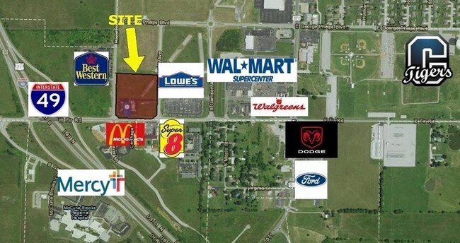

NEARBY LISTINGS FOR SALE OR LEASE
Property Detail
609 W Fir Rd
Other Market Areas
Myers Park Sub
Joplin, MO
MYERS PARK SUB PLAT 3 LOT 3 BLK 3 EX COM SW COR SE 1/4 SEC 16 N 89 DEG E 351.21 N 48.42 TO N R/W FIR RD & POB N 264.77 S 88 DEG E 242.19 N 76 DEG E 25.07 TO W R/W ANNIE
14-5.0-16-00-000-018.000
Jasper
Apartment
Missouri
2024
3
2025
1.96 AC
011800
Missouri South Area
8,463 SF
DEMOGRAPHICS near 609 W Fir Rd
1 Mile
3 Mile
5 Mile
2024 Total Population
2,200
17,747
22,853
2029 Population
2,242
18,177
23,379
Pop Growth 2024-2029
+ 1.91%
+ 2.42%
+ 2.30%
Average Age
41
38
38
2024 Total Households
906
6,384
8,241
HH Growth 2024-2029
+ 1.88%
+ 2.37%
+ 2.27%
Median Household Inc
$42,234
$46,002
$49,605
Avg Household Size
2.40
2.60
2.60
2024 Avg HH Vehicles
2.00
2.00
2.00
Median Home Value
$171,219
$144,237
$159,708
Median Year Built
1979
1971
1973
Nearby Places
Map Layers
Map Styles
 Street
 Aerial
- Restaurants
- Banks
- Shops
- Fitness
- Groceries
SALE & LEASE HISTORY
LISTING DATE
SALE/LEASE

Sep 24, 2016
For Sale
Nearby Properties
Address
Land Use
TOTAL SIZE
Lot Size
Zoning
Address
Land Use
TOTAL SIZE
Lot Size
Zoning
85,692 SF
34.91 AC
Address
Land Use
TOTAL SIZE
Lot Size
Zoning
94,171 SF
5.15 AC
Address
Land Use
TOTAL SIZE
Lot Size
Zoning
58,425 SF
6.46 AC
Address
Land Use
TOTAL SIZE
Lot Size
Zoning
40,748 SF
1.49 AC
Address
Land Use
TOTAL SIZE
Lot Size
Zoning
376,444 SF
34.06 AC
Address
Land Use
TOTAL SIZE
Lot Size
Zoning
37,948 SF
66.06 AC
Address
Land Use
TOTAL SIZE
Lot Size
Zoning
169,197 SF
18.82 AC
Address
Land Use
TOTAL SIZE
Lot Size
Zoning
39,434 SF
5.54 AC
Address
Land Use
TOTAL SIZE
Lot Size
Zoning
48,255 SF
6.22 AC
Address
Land Use
TOTAL SIZE
Lot Size
Zoning
23,051 SF
0.92 AC
Address
Land Use
TOTAL SIZE
Lot Size
Zoning
13,956 SF
6.70 AC
Address
Land Use
TOTAL SIZE
Lot Size
Zoning
772,347 SF
29.77 AC
Address
Land Use
TOTAL SIZE
Lot Size
Zoning
109,564 SF
10.23 AC
Address
Land Use
TOTAL SIZE
Lot Size
Zoning
218,600 SF
8.10 AC
Address
Land Use
TOTAL SIZE
Lot Size
Zoning
36,346 SF
10.80 AC
Address
Land Use
TOTAL SIZE
Lot Size
Zoning
28,000 SF
3.83 AC
Address
Land Use
TOTAL SIZE
Lot Size
Zoning
59,940 SF
6.22 AC
Address
Land Use
TOTAL SIZE
Lot Size
Zoning
12,290 SF
0.59 AC
Address
Land Use
TOTAL SIZE
Lot Size
Zoning
20,706 SF
0.53 AC
Address
Land Use
TOTAL SIZE
Lot Size
Zoning
352,558 SF
9.82 AC
Address
Land Use
TOTAL SIZE
Lot Size
Zoning
28,764 SF
3.92 AC
Address
Land Use
TOTAL SIZE
Lot Size
Zoning
20,914 SF
8.45 AC
Address
Land Use
TOTAL SIZE
Lot Size
Zoning
7.70 AC
Address
Land Use
TOTAL SIZE
Lot Size
Zoning
12,000 SF
14.05 AC
Address
Land Use
TOTAL SIZE
Lot Size
Zoning
31,170 SF
0.83 AC
Address
Land Use
TOTAL SIZE
Lot Size
Zoning
10,544 SF
2.48 AC
Address
Land Use
TOTAL SIZE
Lot Size
Zoning
10,297 SF
4.45 AC
Address
Land Use
TOTAL SIZE
Lot Size
Zoning
283,336 SF
10.14 AC
Address
Land Use
TOTAL SIZE
Lot Size
Zoning
14,448 SF
3.25 AC
Address
Land Use
TOTAL SIZE
Lot Size
Zoning
9,492 SF
0.92 AC
The World's #1 Commercial Real Estate Marketplace
Connect with us
© 2025 CoStar Group
The information above has been obtained from sources believed reliable. While we do not doubt its accuracy we have not verified it and make no guarantee, warranty or representation about it. It is your responsibility to independently confirm its accuracy and completeness. Any projections, opinions, assumptions, or estimates used are for example only and do not represent the current or future performance of the property. The value of this transaction to you depends on tax and other factors which should be evaluated by your tax, financial, and legal advisors. You and your advisors should conduct a careful, independent investigation of the property to determine to your satisfaction the suitability of the property for your needs.