Property Record
609 W Main St, West Dundee, IL 60118


Save to a Folder
{{folder.Name}}
{{folder.ListingIds.length}} Properties
{{folder.ListingIds.length}} Property
Create a New Folder
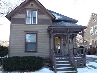
Property Detail
609 W Main St
Chicago-Naperville-Elgin, IL-IN
LOT 3 BLK 7 RANGE CODE: 8 E TWSHP 42N
03-22-455-003
Kane
Commercialnec
Illinois
B and X Area of moderate flood hazard, usually the area between the limits of the 100-year and 500-year floods.
3
2025
0.20 AC
2025
Far Northwest
850500
Chicago
1,288 SF
NEARBY LISTINGS FOR SALE OR LEASE
DEMOGRAPHICS near 609 W Main St
1 mile
3 mile
5 mile
2025 Total Population
7,249
54,931
164,494
2030 Population
7,343
55,552
165,881
Pop Growth 2025-2030
+ 1.30%
+ 1.13%
+ 0.84%
Average Age
43
38
39
2025 Total Households
3,009
18,566
55,767
HH Growth 2025-2030
+ 1.23%
+ 1.20%
+ 0.82%
Median Household Inc
$90,616
$88,887
$92,500
Avg Household Size
2.40
2.90
2.90
2025 Avg HH Vehicles
2.00
2.00
2.00
Median Home Value
$319,895
$273,093
$279,889
Median Year Built
1971
1976
1978
Nearby Places
Map Layers
Map Styles
 Street
 Aerial
Layers
 Traffic
 Biking
Places
Listings with unknown addresses are not visible on the map
- Restaurants
- Banks
- Shops
- Fitness
- Groceries
PUBLIC TRANSPORTATION
COMMUTER RAIL
Elgin Station (Milwaukee District West Line - Northeast Illinois Regional Commuter Railroad (Metra))
Drive
Walk
Distance
Elgin Station (Milwaukee District West Line - Northeast Illinois Regional Commuter Railroad (Metra))
11 min
4.7 mi
Big Timber Road Station (Milwaukee District West Line - Northeast Illinois Regional Commuter Railroad (Metra))
Drive
Walk
Distance
Big Timber Road Station (Milwaukee District West Line - Northeast Illinois Regional Commuter Railroad (Metra))
11 min
4.9 mi
AIRPORT
Chicago O'Hare International
Drive
Walk
Distance
Chicago O'Hare International
53 min
27.9 mi
Chicago Midway International
Drive
Walk
Distance
Chicago Midway International
69 min
44.5 mi
Nearby Properties
Address
Land Use
TOTAL SIZE
Lot Size
Zoning
Address
Land Use
TOTAL SIZE
Lot Size
Zoning
Address
Land Use
TOTAL SIZE
Lot Size
Zoning
551,248 SF
28.94 AC
Address
Land Use
TOTAL SIZE
Lot Size
Zoning
61.92 AC
Address
Land Use
TOTAL SIZE
Lot Size
Zoning
23.54 AC
Address
Land Use
TOTAL SIZE
Lot Size
Zoning
10.88 AC
Address
Land Use
TOTAL SIZE
Lot Size
Zoning
27.33 AC
Address
Land Use
TOTAL SIZE
Lot Size
Zoning
108.60 AC
Address
Land Use
TOTAL SIZE
Lot Size
Zoning
Address
Land Use
TOTAL SIZE
Lot Size
Zoning
431,318 SF
20 AC
Address
Land Use
TOTAL SIZE
Lot Size
Zoning
20.02 AC
Address
Land Use
TOTAL SIZE
Lot Size
Zoning
22.04 AC
Address
Land Use
TOTAL SIZE
Lot Size
Zoning
183,924 SF
0.80 AC
Address
Land Use
TOTAL SIZE
Lot Size
Zoning
211,680 SF
11.60 AC
Address
Land Use
TOTAL SIZE
Lot Size
Zoning
Address
Land Use
TOTAL SIZE
Lot Size
Zoning
211,680 SF
11.34 AC
Address
Land Use
TOTAL SIZE
Lot Size
Zoning
13.53 AC
Address
Land Use
TOTAL SIZE
Lot Size
Zoning
Address
Land Use
TOTAL SIZE
Lot Size
Zoning
Address
Land Use
TOTAL SIZE
Lot Size
Zoning
23.38 AC
Address
Land Use
TOTAL SIZE
Lot Size
Zoning
193,288 SF
16.24 AC
Address
Land Use
TOTAL SIZE
Lot Size
Zoning
176,799 SF
10 AC
Address
Land Use
TOTAL SIZE
Lot Size
Zoning
Address
Land Use
TOTAL SIZE
Lot Size
Zoning
130,050 SF
12.64 AC
Address
Land Use
TOTAL SIZE
Lot Size
Zoning
179,857 SF
4.60 AC
Address
Land Use
TOTAL SIZE
Lot Size
Zoning
154,483 SF
10 AC
Address
Land Use
TOTAL SIZE
Lot Size
Zoning
Address
Land Use
TOTAL SIZE
Lot Size
Zoning
54,000 SF
6.56 AC
Address
Land Use
TOTAL SIZE
Lot Size
Zoning
54,000 SF
7.65 AC
Address
Land Use
TOTAL SIZE
Lot Size
Zoning
151,977 SF
7 AC
Address
Land Use
TOTAL SIZE
Lot Size
Zoning
193,530 SF
0.57 AC
The World's #1 Commercial Real Estate Marketplace
Connect with us
© 2026 CoStar Group
The information above has been obtained from sources believed reliable. While we do not doubt its accuracy we have not verified it and make no guarantee, warranty or representation about it. It is your responsibility to independently confirm its accuracy and completeness. Any projections, opinions, assumptions, or estimates used are for example only and do not represent the current or future performance of the property. The value of this transaction to you depends on tax and other factors which should be evaluated by your tax, financial, and legal advisors. You and your advisors should conduct a careful, independent investigation of the property to determine to your satisfaction the suitability of the property for your needs.