Property Record
6091 Mer Rouge Rd, Bastrop, LA 71220
NEARBY LISTINGS FOR SALE OR LEASE
-
-
View all Bastrop listings for lease on LoopNet.com
Property Detail
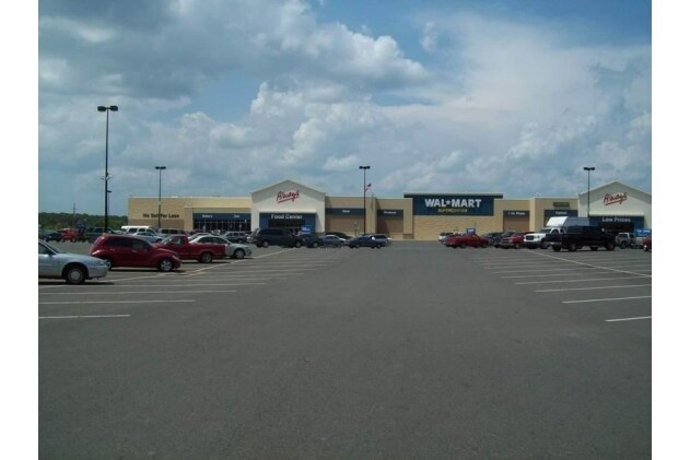
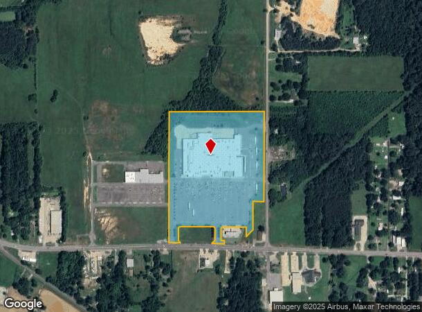
6091 Mer Rouge Rd
Monroe, LA
John S Bond Wal-Mart Subd 1
920005545
LOT 1 OF JOHN S BOND WAL-MART SUBDIVISION OF PLAT BK 11 PAGE A156 DESCRIBED BY METES AND BOUNDS AS BEGINNING AT A PT MARKING
Commercialnec
Morehouse
X
Louisiana
22067C0375C
1
2024
23.12 AC
2024
Louisiana North Area
950200
Other Market Areas
197,062 SF
DEMOGRAPHICS near 6091 Mer Rouge Rd
1 mile
3 mile
5 mile
2024 Total Population
617
9,332
17,641
2029 Population
571
8,732
16,590
Pop Growth 2024-2029
(7.46%)
(6.43%)
(5.96%)
Average Age
45
41
41
2024 Total Households
255
3,768
7,061
HH Growth 2024-2029
(7.06%)
(6.00%)
(5.55%)
Median Household Inc
$33,749
$24,573
$31,043
Avg Household Size
2.30
2.30
2.30
2024 Avg HH Vehicles
2.00
2.00
2.00
Median Home Value
$109,494
$95,570
$93,440
Median Year Built
1975
1972
1974
Nearby Places
Map Layers
Map Styles
 Street
 Aerial
Transit
 Traffic
 Biking
Places
Listings with unknown addresses are not visible on the map
- Restaurants
- Banks
- Shops
- Fitness
- Groceries
PUBLIC TRANSPORTATION
AIRPORT
Monroe Regional
Drive
Walk
Distance
Monroe Regional
38 min
29.3 mi
Freight Ports
Port of Shreveport
Drive
Walk
Distance
Port of Shreveport
164 min
139.8 mi
SALE & LEASE HISTORY
LISTING DATE
SALE/LEASE

Sep 25, 2016
For Lease
Nearby Properties
Address
Land Use
TOTAL SIZE
Lot Size
Zoning
Address
Land Use
TOTAL SIZE
Lot Size
Zoning
Address
Land Use
TOTAL SIZE
Lot Size
Zoning
61,904 SF
4.51 AC
Address
Land Use
TOTAL SIZE
Lot Size
Zoning
0.61 AC
Address
Land Use
TOTAL SIZE
Lot Size
Zoning
61,738 SF
6 AC
Address
Land Use
TOTAL SIZE
Lot Size
Zoning
153,814 SF
6.17 AC
Address
Land Use
TOTAL SIZE
Lot Size
Zoning
60,718 SF
2.23 AC
Address
Land Use
TOTAL SIZE
Lot Size
Zoning
Address
Land Use
TOTAL SIZE
Lot Size
Zoning
37,319 SF
3.49 AC
Address
Land Use
TOTAL SIZE
Lot Size
Zoning
128,609 SF
20 AC
Address
Land Use
TOTAL SIZE
Lot Size
Zoning
95,592 SF
19.93 AC
Address
Land Use
TOTAL SIZE
Lot Size
Zoning
50,822 SF
3.45 AC
Address
Land Use
TOTAL SIZE
Lot Size
Zoning
Address
Land Use
TOTAL SIZE
Lot Size
Zoning
Address
Land Use
TOTAL SIZE
Lot Size
Zoning
22,715 SF
Address
Land Use
TOTAL SIZE
Lot Size
Zoning
35,900 SF
12 AC
Address
Land Use
TOTAL SIZE
Lot Size
Zoning
58,378 SF
0.25 AC
Address
Land Use
TOTAL SIZE
Lot Size
Zoning
46,606 SF
9 AC
Address
Land Use
TOTAL SIZE
Lot Size
Zoning
57,725 SF
6 AC
Address
Land Use
TOTAL SIZE
Lot Size
Zoning
23,552 SF
4 AC
Address
Land Use
TOTAL SIZE
Lot Size
Zoning
18,900 SF
3.70 AC
Address
Land Use
TOTAL SIZE
Lot Size
Zoning
49,419 SF
2.89 AC
Address
Land Use
TOTAL SIZE
Lot Size
Zoning
46,441 SF
2.61 AC
Address
Land Use
TOTAL SIZE
Lot Size
Zoning
119,320 SF
10 AC
Address
Land Use
TOTAL SIZE
Lot Size
Zoning
Address
Land Use
TOTAL SIZE
Lot Size
Zoning
69,640 SF
21 AC
Address
Land Use
TOTAL SIZE
Lot Size
Zoning
14,866 SF
5.65 AC
Address
Land Use
TOTAL SIZE
Lot Size
Zoning
Address
Land Use
TOTAL SIZE
Lot Size
Zoning
14,814 SF
0.97 AC
Address
Land Use
TOTAL SIZE
Lot Size
Zoning
33,176 SF
0.45 AC
The World's #1 Commercial Real Estate Marketplace
Connect with us
© 2026 CoStar Group
The information above has been obtained from sources believed reliable. While we do not doubt its accuracy we have not verified it and make no guarantee, warranty or representation about it. It is your responsibility to independently confirm its accuracy and completeness. Any projections, opinions, assumptions, or estimates used are for example only and do not represent the current or future performance of the property. The value of this transaction to you depends on tax and other factors which should be evaluated by your tax, financial, and legal advisors. You and your advisors should conduct a careful, independent investigation of the property to determine to your satisfaction the suitability of the property for your needs.