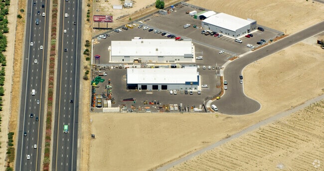
Property Record
6093 S Lincoln Ct, Fresno, CA 93725

NEARBY LISTINGS FOR SALE OR LEASE
Property Detail
6093 S Lincoln Ct
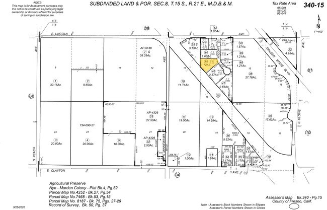
340-150-45
Parcel Map No 8187
Warehouse
1.72 PAR D OF P/M 8187 BK 75 PGS 27-29
X
Fresno
06019C2139H
California
2025
1.72 AC
2025
S Fresno/Hwy 99 Corr
001600
Fresno
20,048 SF
Fresno, CA
DEMOGRAPHICS near 6093 S Lincoln Ct
1 Mile
3 Mile
5 Mile
2024 Total Population
224
10,604
36,180
2029 Population
224
10,801
36,727
Pop Growth 2024-2029
0.00%
+ 1.86%
+ 1.51%
Average Age
36
37
35
2024 Total Households
62
3,120
9,738
HH Growth 2024-2029
0.00%
+ 1.86%
+ 1.48%
Median Household Inc
$69,374
$64,293
$74,253
Avg Household Size
3.50
3.40
3.60
2024 Avg HH Vehicles
2.00
2.00
2.00
Median Home Value
$373,076
$350,765
$335,851
Median Year Built
1975
1980
1993
Nearby Places
Map Layers
Map Styles
 Street
 Aerial
- Restaurants
- Banks
- Shops
- Fitness
- Groceries
PUBLIC TRANSPORTATION
COMMUTER RAIL
Fresno (San Joaquins - Amtrak)
DRIVE
WALK
Distance
Fresno (San Joaquins - Amtrak)
11 min
8.3 mi
AIRPORT
Fresno Yosemite International
DRIVE
WALK
Distance
Fresno Yosemite International
18 min
10.2 mi
Freight Ports
Port of Stockton
DRIVE
WALK
Distance
Port of Stockton
157 min
134.8 mi
Nearby Properties
Address
Land Use
TOTAL SIZE
Lot Size
Zoning
Address
Land Use
TOTAL SIZE
Lot Size
Zoning
725,468 SF
25 AC
MI
Address
Land Use
TOTAL SIZE
Lot Size
Zoning
732,149 SF
77.34 AC
M3
Address
Land Use
TOTAL SIZE
Lot Size
Zoning
242,970 SF
30.43 AC
Address
Land Use
TOTAL SIZE
Lot Size
Zoning
270,292 SF
23.86 AC
M1
Address
Land Use
TOTAL SIZE
Lot Size
Zoning
12,088 SF
23.62 AC
M3
Address
Land Use
TOTAL SIZE
Lot Size
Zoning
84,376 SF
20 AC
AE20
Address
Land Use
TOTAL SIZE
Lot Size
Zoning
410,925 SF
18.77 AC
M3
Address
Land Use
TOTAL SIZE
Lot Size
Zoning
514,976 SF
24.18 AC
M3
Address
Land Use
TOTAL SIZE
Lot Size
Zoning
425,074 SF
15.69 AC
M3
Address
Land Use
TOTAL SIZE
Lot Size
Zoning
326,400 SF
17.03 AC
M1
Address
Land Use
TOTAL SIZE
Lot Size
Zoning
67,162 SF
3.91 AC
RM3
Address
Land Use
TOTAL SIZE
Lot Size
Zoning
150,000 SF
13 AC
M1
Address
Land Use
TOTAL SIZE
Lot Size
Zoning
38,398 SF
14.24 AC
M3
Address
Land Use
TOTAL SIZE
Lot Size
Zoning
297,024 SF
14.94 AC
M3
Address
Land Use
TOTAL SIZE
Lot Size
Zoning
48,941 SF
38.19 AC
AE20
Address
Land Use
TOTAL SIZE
Lot Size
Zoning
249,600 SF
10.89 AC
M3
Address
Land Use
TOTAL SIZE
Lot Size
Zoning
9,000 SF
6.52 AC
M3
Address
Land Use
TOTAL SIZE
Lot Size
Zoning
300,240 SF
17.14 AC
M3
Address
Land Use
TOTAL SIZE
Lot Size
Zoning
113,664 SF
7.79 AC
M3
Address
Land Use
TOTAL SIZE
Lot Size
Zoning
41,400 SF
0.97 AC
CH
Address
Land Use
TOTAL SIZE
Lot Size
Zoning
62,365 SF
7.24 AC
M3
Address
Land Use
TOTAL SIZE
Lot Size
Zoning
181,800 SF
9.25 AC
M3
Address
Land Use
TOTAL SIZE
Lot Size
Zoning
8,744 SF
5.16 AC
M1
Address
Land Use
TOTAL SIZE
Lot Size
Zoning
2,768 SF
1.01 AC
C6
Address
Land Use
TOTAL SIZE
Lot Size
Zoning
163,497 SF
8.89 AC
M1
Address
Land Use
TOTAL SIZE
Lot Size
Zoning
161,280 SF
8.95 AC
M3
Address
Land Use
TOTAL SIZE
Lot Size
Zoning
42,800 SF
7 AC
M2
Address
Land Use
TOTAL SIZE
Lot Size
Zoning
92,100 SF
4.58 AC
M3
Address
Land Use
TOTAL SIZE
Lot Size
Zoning
96,000 SF
6.18 AC
M3
The World's #1 Commercial Real Estate Marketplace
Connect with us
© 2025 CoStar Group
The information above has been obtained from sources believed reliable. While we do not doubt its accuracy we have not verified it and make no guarantee, warranty or representation about it. It is your responsibility to independently confirm its accuracy and completeness. Any projections, opinions, assumptions, or estimates used are for example only and do not represent the current or future performance of the property. The value of this transaction to you depends on tax and other factors which should be evaluated by your tax, financial, and legal advisors. You and your advisors should conduct a careful, independent investigation of the property to determine to your satisfaction the suitability of the property for your needs.