Property Record
Vac/60Th St E Drt Vic Ave, Lake Hughes, CA 93532

This Property Is For Sale
Property Detail
Vac/60Th St E Drt Vic Ave
Los Angeles-Long Beach-Glendale, CA
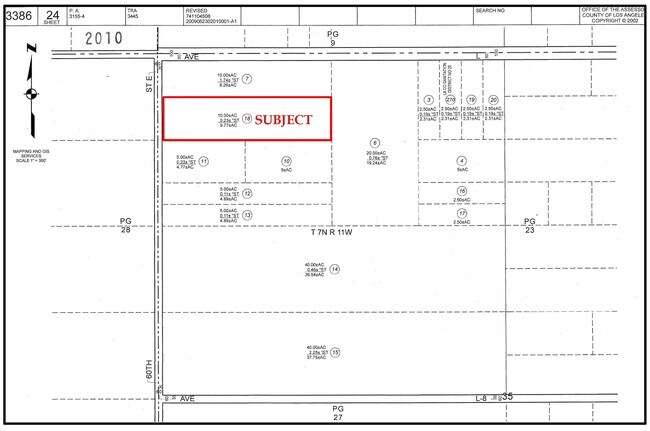
S 1/2 OF N 1/4 OF NW 1/4 OF NW 1/4 (EX OF ST) OF SEC 35 T 7N R 11W
3386-024-018
LOS ANGELES
Desertorbarrenland
California
PDM4
35
AE The base floodplain where base flood elevations are provided. AE Zones are now used on new format FIRMs instead of A1-A30 Zones.
10.02 AC
2024
Antelope Valley
2025
Los Angeles
920102
NEARBY LISTINGS FOR SALE OR LEASE
DEMOGRAPHICS near Vac/60Th St E Drt Vic Ave
1 mile
3 mile
5 mile
2025 Total Population
31
1,914
32,492
2030 Population
32
1,910
32,404
Pop Growth 2025-2030
+ 3.23%
(0.21%)
(0.27%)
Average Age
38
36
36
2025 Total Households
9
537
9,019
HH Growth 2025-2030
0.00%
(0.37%)
(0.44%)
Median Household Inc
$67,500
$83,028
$73,650
Avg Household Size
3.50
3.50
3.40
2025 Avg HH Vehicles
3.00
2.00
2.00
Median Home Value
$450,000
$436,190
$392,466
Median Year Built
1984
1995
1987
Nearby Places
Map Layers
Map Styles
 Street
 Aerial
Transit
 Traffic
 Biking
Places
Listings with unknown addresses are not visible on the map
- Restaurants
- Banks
- Shops
- Fitness
- Groceries
PUBLIC TRANSPORTATION
COMMUTER RAIL
Lancaster (Antelope Valley Line - Southern California Regional Rail Authority (Metrolink))
Drive
Walk
Distance
Lancaster (Antelope Valley Line - Southern California Regional Rail Authority (Metrolink))
16 min
9.0 mi
Nearby Properties
Address
Land Use
TOTAL SIZE
Lot Size
Zoning
Address
Land Use
TOTAL SIZE
Lot Size
Zoning
1,256 SF
158.45 AC
PDM2 1/2*
Address
Land Use
TOTAL SIZE
Lot Size
Zoning
74,797 SF
15.44 AC
LCA21*
Address
Land Use
TOTAL SIZE
Lot Size
Zoning
3,874 SF
38.70 AC
PDM2 1/2-A
Address
Land Use
TOTAL SIZE
Lot Size
Zoning
38.55 AC
PDMI
Address
Land Use
TOTAL SIZE
Lot Size
Zoning
1,917 SF
469.84 AC
LRR2.5
Address
Land Use
TOTAL SIZE
Lot Size
Zoning
7,300 SF
77.91 AC
PDM2
Address
Land Use
TOTAL SIZE
Lot Size
Zoning
279.67 AC
LCA21*
Address
Land Use
TOTAL SIZE
Lot Size
Zoning
325.63 AC
LCA11*
Address
Land Use
TOTAL SIZE
Lot Size
Zoning
5,482 SF
98.77 AC
POM11/2-A2
Address
Land Use
TOTAL SIZE
Lot Size
Zoning
1 SF
121.43 AC
LCA21*
Address
Land Use
TOTAL SIZE
Lot Size
Zoning
73.50 AC
LCA11*
Address
Land Use
TOTAL SIZE
Lot Size
Zoning
160.73 AC
LRR2.5
Address
Land Use
TOTAL SIZE
Lot Size
Zoning
158.16 AC
LCC4-R1750
Address
Land Use
TOTAL SIZE
Lot Size
Zoning
20.48 AC
LCA21*
Address
Land Use
TOTAL SIZE
Lot Size
Zoning
10.03 AC
LCA22*
Address
Land Use
TOTAL SIZE
Lot Size
Zoning
79.30 AC
PDM*
Address
Land Use
TOTAL SIZE
Lot Size
Zoning
184.51 AC
LCM11/2*
Address
Land Use
TOTAL SIZE
Lot Size
Zoning
30.91 AC
LRR7000*
Address
Land Use
TOTAL SIZE
Lot Size
Zoning
158.45 AC
LCA25*
Address
Land Use
TOTAL SIZE
Lot Size
Zoning
19.43 AC
LRA22*
Address
Land Use
TOTAL SIZE
Lot Size
Zoning
153.12 AC
LCA25*
Address
Land Use
TOTAL SIZE
Lot Size
Zoning
29.75 AC
LR RR2.5
Address
Land Use
TOTAL SIZE
Lot Size
Zoning
700 SF
77.66 AC
LCA21*
Address
Land Use
TOTAL SIZE
Lot Size
Zoning
80.15 AC
LCA21*
Address
Land Use
TOTAL SIZE
Lot Size
Zoning
81.43 AC
LRR2.5
Address
Land Use
TOTAL SIZE
Lot Size
Zoning
27.52 AC
LR RR2.5
Address
Land Use
TOTAL SIZE
Lot Size
Zoning
2,331 SF
81.64 AC
LCA21*
Address
Land Use
TOTAL SIZE
Lot Size
Zoning
40.28 AC
PDLI
Address
Land Use
TOTAL SIZE
Lot Size
Zoning
40.27 AC
PDLI
Address
Land Use
TOTAL SIZE
Lot Size
Zoning
79.76 AC
LCA21*
The World's #1 Commercial Real Estate Marketplace
Connect with us
© 2026 CoStar Group
The information above has been obtained from sources believed reliable. While we do not doubt its accuracy we have not verified it and make no guarantee, warranty or representation about it. It is your responsibility to independently confirm its accuracy and completeness. Any projections, opinions, assumptions, or estimates used are for example only and do not represent the current or future performance of the property. The value of this transaction to you depends on tax and other factors which should be evaluated by your tax, financial, and legal advisors. You and your advisors should conduct a careful, independent investigation of the property to determine to your satisfaction the suitability of the property for your needs.