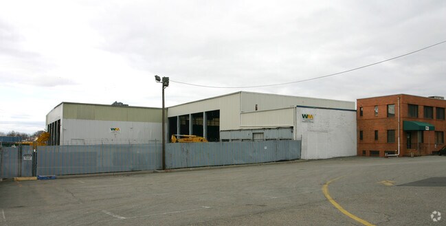
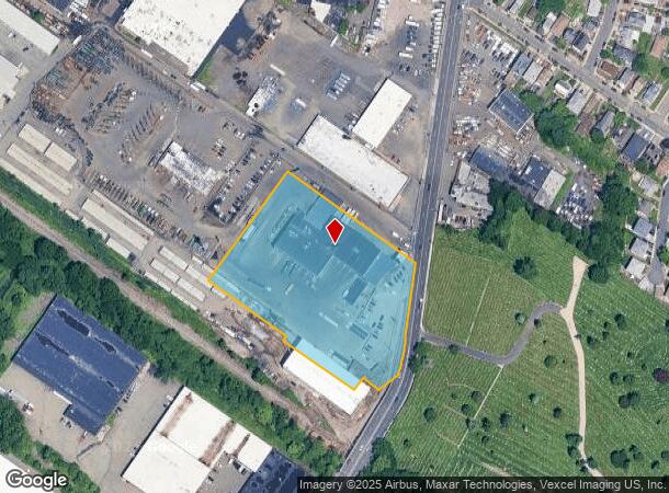
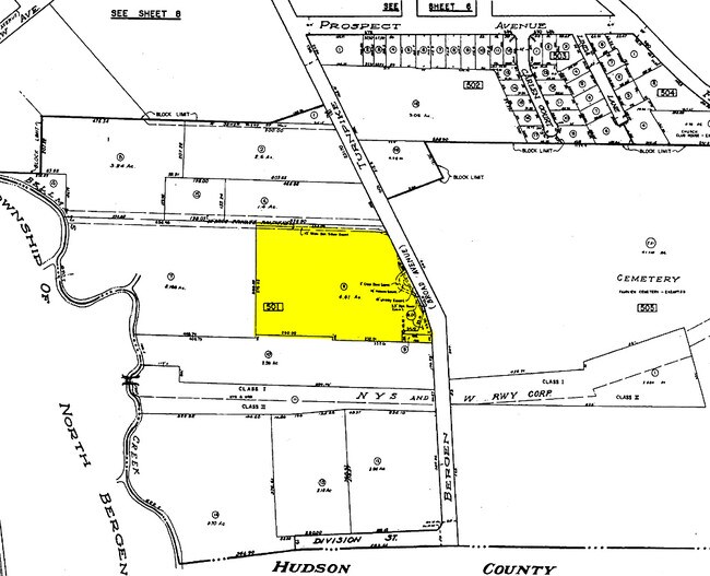
Property Record
61 Broad Ave, Fairview, NJ 07022
NEARBY LISTINGS FOR SALE OR LEASE
Property Detail
61 Broad Ave
18-00501-0000-00008
4.530 ACRES
Industrialgeneral
Bergen
X
New Jersey
34003C0259H
8
2024
4.53 AC
2025
Englewood/Edgewater
018200
Northern New Jersey
23,638 SF
New York-Jersey City-White Plains, NY-NJ
DEMOGRAPHICS near 61 Broad Ave
1 Mile
3 Mile
5 Mile
2024 Total Population
36,283
470,020
1,693,244
2029 Population
34,761
444,477
1,588,983
Pop Growth 2024-2029
(4.19%)
(5.43%)
(6.16%)
Average Age
39
42
41
2024 Total Households
12,373
195,995
742,660
HH Growth 2024-2029
(4.32%)
(5.80%)
(6.51%)
Median Household Inc
$68,390
$83,057
$76,736
Avg Household Size
2.80
2.30
2.20
2024 Avg HH Vehicles
1.00
1.00
1.00
Median Home Value
$464,187
$689,807
$754,337
Median Year Built
1953
1951
1957
Nearby Places
Map Layers
Map Styles
 Street
 Aerial
- Restaurants
- Banks
- Shops
- Fitness
- Groceries
PUBLIC TRANSPORTATION
COMMUTER RAIL
Meadowlands Sports Complex Station (BetMGM Meadowlands Rail Line - NJ TRANSIT RAIL)
DRIVE
WALK
Distance
Meadowlands Sports Complex Station (BetMGM Meadowlands Rail Line - NJ TRANSIT RAIL)
12 min
7.7 mi
Harlem-125Th Street Station (Harlem Line - Metro-North Commuter Railroad Company (Metro-North), Hudson Line - Metro-North Commuter Railroad Company (Metro-North), New Haven Line - Metro-North Commuter Railroad Company (Metro-North))
DRIVE
WALK
Distance
Harlem-125Th Street Station (Harlem Line - Metro-North Commuter Railroad Company (Metro-North), Hudson Line - Metro-North Commuter Railroad Company (Metro-North), New Haven Line - Metro-North Commuter Railroad Company (Metro-North))
16 min
9.9 mi
AIRPORT
Newark Liberty International
DRIVE
WALK
Distance
Newark Liberty International
17 min
13.6 mi
LaGuardia
DRIVE
WALK
Distance
LaGuardia
27 min
15.7 mi
John F Kennedy International
DRIVE
WALK
Distance
John F Kennedy International
38 min
26.7 mi
Freight Ports
NY - Red Hook Container Terminal
DRIVE
WALK
Distance
NY - Red Hook Container Terminal
26 min
13.7 mi
Nearby Properties
Address
Land Use
TOTAL SIZE
Lot Size
Zoning
Address
Land Use
TOTAL SIZE
Lot Size
Zoning
Address
Land Use
TOTAL SIZE
Lot Size
Zoning
174 AC
P2
Address
Land Use
TOTAL SIZE
Lot Size
Zoning
26.93 AC
R8
Address
Land Use
TOTAL SIZE
Lot Size
Zoning
1,368,870 SF
16.86 AC
R8
Address
Land Use
TOTAL SIZE
Lot Size
Zoning
555 SF
4.89 AC
H
Address
Land Use
TOTAL SIZE
Lot Size
Zoning
4,000 SF
57.37 AC
BPC
Address
Land Use
TOTAL SIZE
Lot Size
Zoning
35.58 AC
I
Address
Land Use
TOTAL SIZE
Lot Size
Zoning
4.87 AC
R11
Address
Land Use
TOTAL SIZE
Lot Size
Zoning
68.93 AC
Address
Land Use
TOTAL SIZE
Lot Size
Zoning
0.06 AC
R8
Address
Land Use
TOTAL SIZE
Lot Size
Zoning
1,670,868 SF
9.14 AC
R8
Address
Land Use
TOTAL SIZE
Lot Size
Zoning
7.64 AC
Address
Land Use
TOTAL SIZE
Lot Size
Zoning
45.60 AC
Address
Land Use
TOTAL SIZE
Lot Size
Zoning
478,842 SF
3.56 AC
C6-1
Address
Land Use
TOTAL SIZE
Lot Size
Zoning
8.60 AC
P1
Address
Land Use
TOTAL SIZE
Lot Size
Zoning
13.60 AC
Address
Land Use
TOTAL SIZE
Lot Size
Zoning
4.40 AC
Address
Land Use
TOTAL SIZE
Lot Size
Zoning
3.60 AC
OR1
Address
Land Use
TOTAL SIZE
Lot Size
Zoning
2,056 SF
0.06 AC
R1
Address
Land Use
TOTAL SIZE
Lot Size
Zoning
698,122 SF
3.47 AC
R8
Address
Land Use
TOTAL SIZE
Lot Size
Zoning
489 SF
1.24 AC
B2A
Address
Land Use
TOTAL SIZE
Lot Size
Zoning
13.09 AC
Address
Land Use
TOTAL SIZE
Lot Size
Zoning
555 SF
32 AC
H
Address
Land Use
TOTAL SIZE
Lot Size
Zoning
1,390,324 SF
6.87 AC
R8
Address
Land Use
TOTAL SIZE
Lot Size
Zoning
3.75 AC
Address
Land Use
TOTAL SIZE
Lot Size
Zoning
26 AC
H
Address
Land Use
TOTAL SIZE
Lot Size
Zoning
555 SF
23 AC
Address
Land Use
TOTAL SIZE
Lot Size
Zoning
3.62 AC
R5
Address
Land Use
TOTAL SIZE
Lot Size
Zoning
Address
Land Use
TOTAL SIZE
Lot Size
Zoning
The World's #1 Commercial Real Estate Marketplace
Connect with us
© 2025 CoStar Group
The information above has been obtained from sources believed reliable. While we do not doubt its accuracy we have not verified it and make no guarantee, warranty or representation about it. It is your responsibility to independently confirm its accuracy and completeness. Any projections, opinions, assumptions, or estimates used are for example only and do not represent the current or future performance of the property. The value of this transaction to you depends on tax and other factors which should be evaluated by your tax, financial, and legal advisors. You and your advisors should conduct a careful, independent investigation of the property to determine to your satisfaction the suitability of the property for your needs.