Property Record
61 Carton St, Rumson, NJ 07760
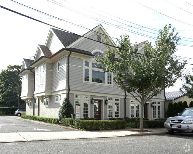

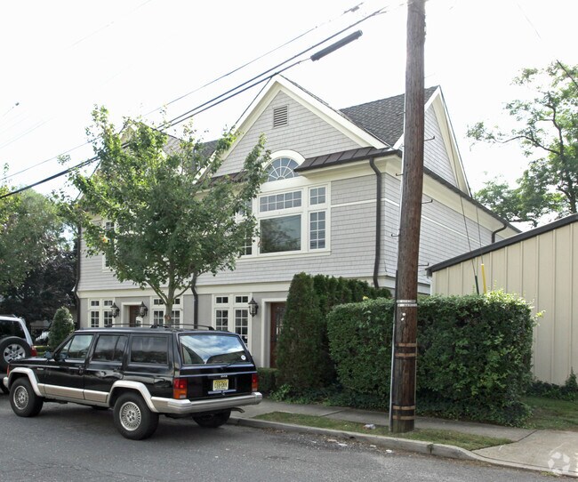

Property Detail
61 Carton St
41-00060-0000-00003
Monmouth
Officebuilding
New Jersey
MU0
3
B and X Area of moderate flood hazard, usually the area between the limits of the 100-year and 500-year floods.
0.20 AC
2024
Eastern Monmouth
2025
Northern New Jersey
803900
Lakewood-New Brunswick, NJ
3,760 SF
NEARBY LISTINGS FOR SALE OR LEASE
DEMOGRAPHICS near 61 Carton St
1 mile
3 mile
5 mile
2025 Total Population
4,537
29,908
92,358
2030 Population
4,502
30,278
92,570
Pop Growth 2025-2030
(0.77%)
+ 1.24%
+ 0.23%
Average Age
40
43
42
2025 Total Households
1,508
12,206
36,226
HH Growth 2025-2030
(0.93%)
+ 1.56%
+ 0.33%
Median Household Inc
$230,942
$143,965
$121,995
Avg Household Size
3.00
2.40
2.50
2025 Avg HH Vehicles
2.00
2.00
2.00
Median Home Value
$1,087,633
$919,216
$774,698
Median Year Built
1959
1969
1965
Nearby Places
Map Layers
Map Styles
 Street
 Aerial
Layers
 Traffic
 Biking
Places
Listings with unknown addresses are not visible on the map
- Restaurants
- Banks
- Shops
- Fitness
- Groceries
PUBLIC TRANSPORTATION
COMMUTER RAIL
Little Silver (North Jersey Coast Line - NJ Transit Commuter Rail (NJ Transit))
Drive
Walk
Distance
Little Silver (North Jersey Coast Line - NJ Transit Commuter Rail (NJ Transit))
9 min
4.9 mi
Red Bank (North Jersey Coast Line - NJ Transit Commuter Rail (NJ Transit))
Drive
Walk
Distance
Red Bank (North Jersey Coast Line - NJ Transit Commuter Rail (NJ Transit))
11 min
5.0 mi
AIRPORT
Newark Liberty International
Drive
Walk
Distance
Newark Liberty International
57 min
40.8 mi
Freight Ports
New York Container Terminal
Drive
Walk
Distance
New York Container Terminal
50 min
35.9 mi
SALE & LEASE HISTORY
LISTING DATE
SALE/LEASE

Sep 25, 2016
For Lease
Nov 06, 2018
For Lease
Nearby Properties
Address
Land Use
TOTAL SIZE
Lot Size
Zoning
Address
Land Use
TOTAL SIZE
Lot Size
Zoning
16,276 SF
162.59 AC
R-1
Address
Land Use
TOTAL SIZE
Lot Size
Zoning
167,221 SF
18.74 AC
CONREC
Address
Land Use
TOTAL SIZE
Lot Size
Zoning
35.84 AC
R22
Address
Land Use
TOTAL SIZE
Lot Size
Zoning
251,314 SF
53.63 AC
R-1A
Address
Land Use
TOTAL SIZE
Lot Size
Zoning
47,470 SF
15.43 AC
CONREC
Address
Land Use
TOTAL SIZE
Lot Size
Zoning
37 AC
H-BP
Address
Land Use
TOTAL SIZE
Lot Size
Zoning
14.48 AC
MU08
Address
Land Use
TOTAL SIZE
Lot Size
Zoning
2,166 SF
77.43 AC
CONREC
Address
Land Use
TOTAL SIZE
Lot Size
Zoning
1,800 SF
504.53 AC
SF80
Address
Land Use
TOTAL SIZE
Lot Size
Zoning
82,212 SF
11.72 AC
R-1
Address
Land Use
TOTAL SIZE
Lot Size
Zoning
54,520 SF
7.46 AC
R-2
Address
Land Use
TOTAL SIZE
Lot Size
Zoning
163,312 SF
16.21 AC
MF15
Address
Land Use
TOTAL SIZE
Lot Size
Zoning
9 AC
CONREC
Address
Land Use
TOTAL SIZE
Lot Size
Zoning
8,923 SF
9.05 AC
C50
Address
Land Use
TOTAL SIZE
Lot Size
Zoning
15,866 SF
4.85 AC
SF40
Address
Land Use
TOTAL SIZE
Lot Size
Zoning
641 SF
23.44 AC
CONREC
Address
Land Use
TOTAL SIZE
Lot Size
Zoning
50,339 SF
10.50 AC
B3
Address
Land Use
TOTAL SIZE
Lot Size
Zoning
178 AC
R110
Address
Land Use
TOTAL SIZE
Lot Size
Zoning
19,447 SF
1.15 AC
R110
Address
Land Use
TOTAL SIZE
Lot Size
Zoning
162.89 AC
R110
Address
Land Use
TOTAL SIZE
Lot Size
Zoning
74,620 SF
0.87 AC
MF08
Address
Land Use
TOTAL SIZE
Lot Size
Zoning
19,766 SF
8.37 AC
SF80
Address
Land Use
TOTAL SIZE
Lot Size
Zoning
1,972 SF
95.96 AC
R110
Address
Land Use
TOTAL SIZE
Lot Size
Zoning
93,620 SF
11.86 AC
SF05
Address
Land Use
TOTAL SIZE
Lot Size
Zoning
6,168 SF
13.24 AC
Address
Land Use
TOTAL SIZE
Lot Size
Zoning
21,914 SF
8.26 AC
SF10
Address
Land Use
TOTAL SIZE
Lot Size
Zoning
32,258 SF
5.05 AC
C50
Address
Land Use
TOTAL SIZE
Lot Size
Zoning
20,245 SF
1.14 AC
R110
Address
Land Use
TOTAL SIZE
Lot Size
Zoning
44,207 SF
5.92 AC
C50
Address
Land Use
TOTAL SIZE
Lot Size
Zoning
23,778 SF
1.55 AC
SF0
The World's #1 Commercial Real Estate Marketplace
Connect with us
© 2026 CoStar Group
The information above has been obtained from sources believed reliable. While we do not doubt its accuracy we have not verified it and make no guarantee, warranty or representation about it. It is your responsibility to independently confirm its accuracy and completeness. Any projections, opinions, assumptions, or estimates used are for example only and do not represent the current or future performance of the property. The value of this transaction to you depends on tax and other factors which should be evaluated by your tax, financial, and legal advisors. You and your advisors should conduct a careful, independent investigation of the property to determine to your satisfaction the suitability of the property for your needs.