Property Record
65 Clinton St, Malden, MA 02148
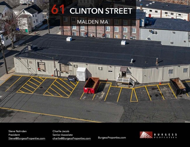
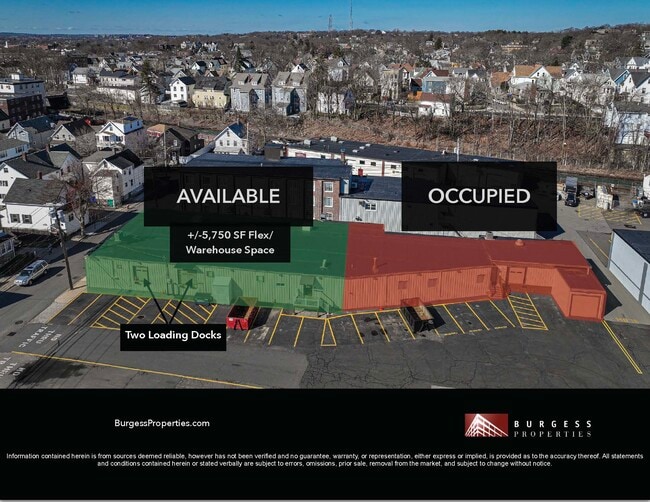
Current Lease Availabilities
NEARBY LISTINGS FOR SALE OR LEASE
Property Detail
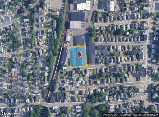
65 Clinton St
MALD-000011-000854-000412
Middlesex
Industrialgeneral
Massachusetts
X
412
25017C0437F
1.04 AC
2025
Medford/Malden
2025
Boston
341302
Boston-Cambridge-Newton, MA-NH
DEMOGRAPHICS near 65 Clinton St
1 Mile
3 Mile
5 Mile
2024 Total Population
36,900
219,844
639,349
2029 Population
36,000
214,064
621,002
Pop Growth 2024-2029
(2.44%)
(2.63%)
(2.87%)
Average Age
39
39
39
2024 Total Households
15,075
85,587
260,204
HH Growth 2024-2029
(2.35%)
(2.56%)
(2.91%)
Median Household Inc
$83,510
$91,228
$99,194
Avg Household Size
2.30
2.50
2.30
2024 Avg HH Vehicles
1.00
1.00
1.00
Median Home Value
$644,783
$651,658
$713,961
Median Year Built
1950
1949
1949
Nearby Places
- Restaurants
- Banks
- Shops
- Fitness
- Groceries
PUBLIC TRANSPORTATION
TRANSIT/SUBWAY
Oak Grove Station (Orange Line - Massachusetts Bay Transportation Authority Subway (The T))
DRIVE
WALK
Distance
Oak Grove Station (Orange Line - Massachusetts Bay Transportation Authority Subway (The T))
1 min
6 min
0.3 mi
Malden Center Station (Orange Line - Massachusetts Bay Transportation Authority Subway (The T))
DRIVE
WALK
Distance
Malden Center Station (Orange Line - Massachusetts Bay Transportation Authority Subway (The T))
2 min
12 min
0.7 mi
COMMUTER RAIL
Malden Center (Haverhill Line - Massachusetts Bay Transportation Authority Commuter Rail (Purple Line))
DRIVE
WALK
Distance
Malden Center (Haverhill Line - Massachusetts Bay Transportation Authority Commuter Rail (Purple Line))
2 min
12 min
0.7 mi
Wyoming Hill (Haverhill Line - Massachusetts Bay Transportation Authority Commuter Rail (Purple Line))
DRIVE
WALK
Distance
Wyoming Hill (Haverhill Line - Massachusetts Bay Transportation Authority Commuter Rail (Purple Line))
3 min
1.4 mi
AIRPORT
General Edward Lawrence Logan International
DRIVE
WALK
Distance
General Edward Lawrence Logan International
15 min
6.8 mi
Freight Ports
Port of Boston
DRIVE
WALK
Distance
Port of Boston
18 min
8.9 mi
Nearby Properties
Address
Land Use
TOTAL SIZE
Lot Size
Zoning
Address
Land Use
TOTAL SIZE
Lot Size
Zoning
8 AC
HB
Address
Land Use
TOTAL SIZE
Lot Size
Zoning
646,546 SF
89.28 AC
ROD
Address
Land Use
TOTAL SIZE
Lot Size
Zoning
386,825 SF
10.67 AC
Address
Land Use
TOTAL SIZE
Lot Size
Zoning
410,642 SF
4.68 AC
CTED
Address
Land Use
TOTAL SIZE
Lot Size
Zoning
43.90 AC
Address
Land Use
TOTAL SIZE
Lot Size
Zoning
234,450 SF
3.49 AC
I
Address
Land Use
TOTAL SIZE
Lot Size
Zoning
297,396 SF
2.79 AC
CTED
Address
Land Use
TOTAL SIZE
Lot Size
Zoning
Address
Land Use
TOTAL SIZE
Lot Size
Zoning
530,113 SF
29.43 AC
Address
Land Use
TOTAL SIZE
Lot Size
Zoning
6.73 AC
HB
Address
Land Use
TOTAL SIZE
Lot Size
Zoning
13.48 AC
Address
Land Use
TOTAL SIZE
Lot Size
Zoning
19,308 SF
82.36 AC
NA
Address
Land Use
TOTAL SIZE
Lot Size
Zoning
254,075 SF
3.70 AC
Address
Land Use
TOTAL SIZE
Lot Size
Zoning
21,024 SF
18.19 AC
Address
Land Use
TOTAL SIZE
Lot Size
Zoning
253,859 SF
3.18 AC
Address
Land Use
TOTAL SIZE
Lot Size
Zoning
454,752 SF
6.22 AC
Address
Land Use
TOTAL SIZE
Lot Size
Zoning
7,736 SF
24.56 AC
UR
Address
Land Use
TOTAL SIZE
Lot Size
Zoning
129,898 SF
43.82 AC
ID
Address
Land Use
TOTAL SIZE
Lot Size
Zoning
Address
Land Use
TOTAL SIZE
Lot Size
Zoning
194,880 SF
35.42 AC
NA
Address
Land Use
TOTAL SIZE
Lot Size
Zoning
359,892 SF
9.06 AC
Address
Land Use
TOTAL SIZE
Lot Size
Zoning
252,796 SF
2.46 AC
ASMD
Address
Land Use
TOTAL SIZE
Lot Size
Zoning
354,723 SF
20.59 AC
BPA
Address
Land Use
TOTAL SIZE
Lot Size
Zoning
292,515 SF
21.61 AC
Address
Land Use
TOTAL SIZE
Lot Size
Zoning
362,358 SF
3.44 AC
CTED
Address
Land Use
TOTAL SIZE
Lot Size
Zoning
0.47 AC
M
Address
Land Use
TOTAL SIZE
Lot Size
Zoning
227,673 SF
1.75 AC
R3
Address
Land Use
TOTAL SIZE
Lot Size
Zoning
303,034 SF
8.81 AC
Address
Land Use
TOTAL SIZE
Lot Size
Zoning
70,134 SF
2.25 AC
CB
Address
Land Use
TOTAL SIZE
Lot Size
Zoning
11.72 AC
The World's #1 Commercial Real Estate Marketplace
Connect with us
© 2025 CoStar Group
The information above has been obtained from sources believed reliable. While we do not doubt its accuracy we have not verified it and make no guarantee, warranty or representation about it. It is your responsibility to independently confirm its accuracy and completeness. Any projections, opinions, assumptions, or estimates used are for example only and do not represent the current or future performance of the property. The value of this transaction to you depends on tax and other factors which should be evaluated by your tax, financial, and legal advisors. You and your advisors should conduct a careful, independent investigation of the property to determine to your satisfaction the suitability of the property for your needs.