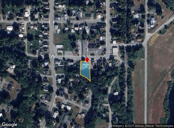
Property Record
61 Depot St, Hartford, VT 05047

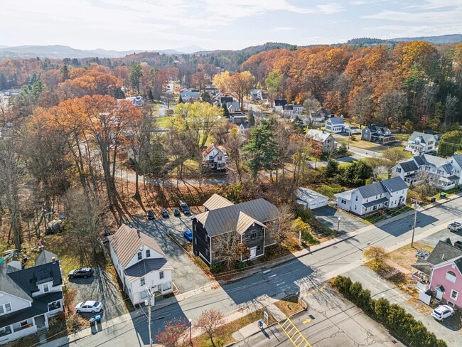
This Property Is For Sale
NEARBY LISTINGS FOR SALE OR LEASE
Property Detail
61 Depot St
285-090-15212
332 OFFICE BLDG
Officebuilding
Windsor
X
Vermont
50027C0526E
0.35 AC
2024
Vermont North Area
2024
Other Market Areas
965502
Claremont-Lebanon, NH-VT
4,640 SF
DEMOGRAPHICS near 61 Depot St
1 Mile
3 Mile
5 Mile
2024 Total Population
2,903
21,500
33,271
2029 Population
2,757
21,530
33,252
Pop Growth 2024-2029
(5.03%)
+ 0.14%
(0.06%)
Average Age
44
38
40
2024 Total Households
1,368
8,130
13,410
HH Growth 2024-2029
(4.82%)
+ 0.07%
(0.07%)
Median Household Inc
$70,948
$87,127
$92,323
Avg Household Size
2.00
2.10
2.10
2024 Avg HH Vehicles
1.00
2.00
2.00
Median Home Value
$284,539
$365,954
$401,970
Median Year Built
1977
1980
1980
Nearby Places
- Restaurants
- Banks
- Shops
- Fitness
- Groceries
PUBLIC TRANSPORTATION
COMMUTER RAIL
White River Junction Amtrak Station (Vermonter - Amtrak)
DRIVE
WALK
Distance
White River Junction Amtrak Station (Vermonter - Amtrak)
4 min
2.0 mi
Freight Ports
Albany, NY Port
DRIVE
WALK
Distance
Albany, NY Port
194 min
132.4 mi
Nearby Properties
Address
Land Use
TOTAL SIZE
Lot Size
Zoning
Address
Land Use
TOTAL SIZE
Lot Size
Zoning
1.13 AC
I
Address
Land Use
TOTAL SIZE
Lot Size
Zoning
163,845 SF
MC
Address
Land Use
TOTAL SIZE
Lot Size
Zoning
0.86 AC
I
Address
Land Use
TOTAL SIZE
Lot Size
Zoning
0.90 AC
I
Address
Land Use
TOTAL SIZE
Lot Size
Zoning
3,136 SF
53.32 AC
R1
Address
Land Use
TOTAL SIZE
Lot Size
Zoning
0.53 AC
I
Address
Land Use
TOTAL SIZE
Lot Size
Zoning
16,384 SF
4.46 AC
I
Address
Land Use
TOTAL SIZE
Lot Size
Zoning
31.50 AC
Address
Land Use
TOTAL SIZE
Lot Size
Zoning
Address
Land Use
TOTAL SIZE
Lot Size
Zoning
3.76 AC
GC
Address
Land Use
TOTAL SIZE
Lot Size
Zoning
0.34 AC
I
Address
Land Use
TOTAL SIZE
Lot Size
Zoning
1,315 SF
16.35 AC
RL3
Address
Land Use
TOTAL SIZE
Lot Size
Zoning
4.30 AC
I
Address
Land Use
TOTAL SIZE
Lot Size
Zoning
194,496 SF
28.26 AC
I
Address
Land Use
TOTAL SIZE
Lot Size
Zoning
356.40 AC
RL3
Address
Land Use
TOTAL SIZE
Lot Size
Zoning
191,951 SF
17.70 AC
R1
Address
Land Use
TOTAL SIZE
Lot Size
Zoning
430,065 SF
23.35 AC
I
Address
Land Use
TOTAL SIZE
Lot Size
Zoning
86.78 AC
IC
Address
Land Use
TOTAL SIZE
Lot Size
Zoning
27.89 AC
I
Address
Land Use
TOTAL SIZE
Lot Size
Zoning
22.14 AC
GC
Address
Land Use
TOTAL SIZE
Lot Size
Zoning
10.20 AC
R3
Address
Land Use
TOTAL SIZE
Lot Size
Zoning
Address
Land Use
TOTAL SIZE
Lot Size
Zoning
75,575 SF
0.78 AC
D1
Address
Land Use
TOTAL SIZE
Lot Size
Zoning
15,481 SF
1.47 AC
I
Address
Land Use
TOTAL SIZE
Lot Size
Zoning
15,481 SF
1.47 AC
I
Address
Land Use
TOTAL SIZE
Lot Size
Zoning
23.33 AC
R3
Address
Land Use
TOTAL SIZE
Lot Size
Zoning
9.80 AC
I
Address
Land Use
TOTAL SIZE
Lot Size
Zoning
Address
Land Use
TOTAL SIZE
Lot Size
Zoning
0.47 AC
I
Address
Land Use
TOTAL SIZE
Lot Size
Zoning
0.46 AC
I
The World's #1 Commercial Real Estate Marketplace
Connect with us
© 2025 CoStar Group
The information above has been obtained from sources believed reliable. While we do not doubt its accuracy we have not verified it and make no guarantee, warranty or representation about it. It is your responsibility to independently confirm its accuracy and completeness. Any projections, opinions, assumptions, or estimates used are for example only and do not represent the current or future performance of the property. The value of this transaction to you depends on tax and other factors which should be evaluated by your tax, financial, and legal advisors. You and your advisors should conduct a careful, independent investigation of the property to determine to your satisfaction the suitability of the property for your needs.