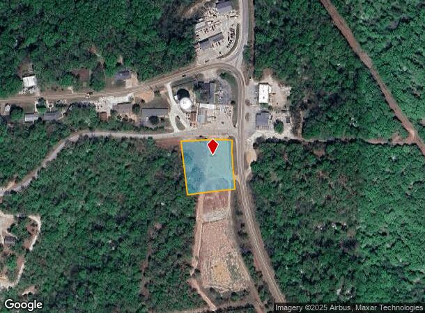
Property Record
61 N Shore Dr, Lake Ozark, MO 65049
NEARBY LISTINGS FOR SALE OR LEASE
-
-
View all Lake Ozark listings for sale on LoopNet.com
Property Detail
61 N Shore Dr
124018003005001000
Subdivision
Storebuilding
LOT 1 CODY'S RIDGE SUBDIVISION
X
Miller
29029C0110C
Missouri
2025
1
2025
1.10 AC
962701
Missouri South Central Area
10,360 SF
Other Market Areas
DEMOGRAPHICS near 61 N Shore Dr
1 Mile
3 Mile
5 Mile
2024 Total Population
975
5,221
12,864
2029 Population
1,106
5,703
14,042
Pop Growth 2024-2029
+ 13.44%
+ 9.23%
+ 9.16%
Average Age
47
45
46
2024 Total Households
420
2,260
5,620
HH Growth 2024-2029
+ 13.57%
+ 8.94%
+ 8.65%
Median Household Inc
$92,812
$67,232
$63,705
Avg Household Size
2.30
2.30
2.20
2024 Avg HH Vehicles
2.00
2.00
2.00
Median Home Value
$264,545
$268,090
$273,134
Median Year Built
1994
1987
1986
Nearby Places
Map Layers
Map Styles
 Street
 Aerial
- Restaurants
- Banks
- Shops
- Fitness
- Groceries
SALE & LEASE HISTORY
LISTING DATE
SALE/LEASE

Aug 05, 2024
For Sale
Nearby Properties
Address
Land Use
TOTAL SIZE
Lot Size
Zoning
Address
Land Use
TOTAL SIZE
Lot Size
Zoning
153,990 SF
16.50 AC
Address
Land Use
TOTAL SIZE
Lot Size
Zoning
1,786 SF
10.30 AC
Address
Land Use
TOTAL SIZE
Lot Size
Zoning
5,143 SF
3.90 AC
Address
Land Use
TOTAL SIZE
Lot Size
Zoning
22,855 SF
5.40 AC
Address
Land Use
TOTAL SIZE
Lot Size
Zoning
7,200 SF
11.60 AC
Address
Land Use
TOTAL SIZE
Lot Size
Zoning
29,645 SF
115.60 AC
Address
Land Use
TOTAL SIZE
Lot Size
Zoning
6,560 SF
6 AC
Address
Land Use
TOTAL SIZE
Lot Size
Zoning
Address
Land Use
TOTAL SIZE
Lot Size
Zoning
10,000 SF
4.50 AC
Address
Land Use
TOTAL SIZE
Lot Size
Zoning
16,000 SF
12.10 AC
Address
Land Use
TOTAL SIZE
Lot Size
Zoning
5,110 SF
14.10 AC
Address
Land Use
TOTAL SIZE
Lot Size
Zoning
17,382 SF
6.30 AC
Address
Land Use
TOTAL SIZE
Lot Size
Zoning
26,088 SF
3.90 AC
Address
Land Use
TOTAL SIZE
Lot Size
Zoning
20,192 SF
0.77 AC
Address
Land Use
TOTAL SIZE
Lot Size
Zoning
9,035 SF
1.85 AC
Address
Land Use
TOTAL SIZE
Lot Size
Zoning
7,478 SF
0.90 AC
Address
Land Use
TOTAL SIZE
Lot Size
Zoning
4,068 SF
5 AC
Address
Land Use
TOTAL SIZE
Lot Size
Zoning
11,748 SF
1 AC
Address
Land Use
TOTAL SIZE
Lot Size
Zoning
1,636 SF
4 AC
Address
Land Use
TOTAL SIZE
Lot Size
Zoning
3,072 SF
1.10 AC
Address
Land Use
TOTAL SIZE
Lot Size
Zoning
9,609 SF
0.30 AC
Address
Land Use
TOTAL SIZE
Lot Size
Zoning
21,840 SF
6.50 AC
Address
Land Use
TOTAL SIZE
Lot Size
Zoning
11,704 SF
3.80 AC
Address
Land Use
TOTAL SIZE
Lot Size
Zoning
144 SF
49.70 AC
Address
Land Use
TOTAL SIZE
Lot Size
Zoning
21,248 SF
1.30 AC
Address
Land Use
TOTAL SIZE
Lot Size
Zoning
Address
Land Use
TOTAL SIZE
Lot Size
Zoning
Address
Land Use
TOTAL SIZE
Lot Size
Zoning
4,733 SF
0.11 AC
Address
Land Use
TOTAL SIZE
Lot Size
Zoning
51,867 SF
2.90 AC
The World's #1 Commercial Real Estate Marketplace
Connect with us
© 2026 CoStar Group
The information above has been obtained from sources believed reliable. While we do not doubt its accuracy we have not verified it and make no guarantee, warranty or representation about it. It is your responsibility to independently confirm its accuracy and completeness. Any projections, opinions, assumptions, or estimates used are for example only and do not represent the current or future performance of the property. The value of this transaction to you depends on tax and other factors which should be evaluated by your tax, financial, and legal advisors. You and your advisors should conduct a careful, independent investigation of the property to determine to your satisfaction the suitability of the property for your needs.