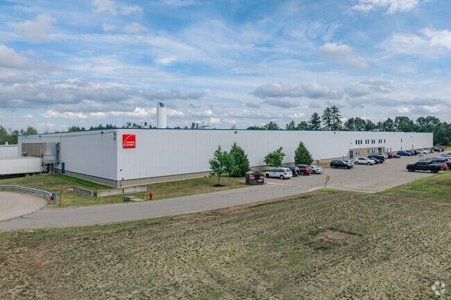
Property Record
61 Pine Rd, Brentwood, NH 03833

Property Detail
61 Pine Rd
Industrialgeneral
Rockingham
COMM/I
New Hampshire
B and X Area of moderate flood hazard, usually the area between the limits of the 100-year and 500-year floods.
40.37 AC
2025
Rockingham
2025
Boston
060000
Boston-Cambridge-Newton, MA-NH
129,542 SF
BREN-000205-000021
NEARBY LISTINGS FOR SALE OR LEASE
DEMOGRAPHICS near 61 Pine Rd
1 mile
3 mile
5 mile
2025 Total Population
530
10,076
31,333
2030 Population
526
10,245
31,740
Pop Growth 2025-2030
(0.75%)
+ 1.68%
+ 1.30%
Average Age
43
44
44
2025 Total Households
172
3,858
12,470
HH Growth 2025-2030
(1.74%)
+ 1.63%
+ 1.20%
Median Household Inc
$147,115
$114,691
$110,414
Avg Household Size
2.70
2.40
2.40
2025 Avg HH Vehicles
2.00
2.00
2.00
Median Home Value
$600,000
$620,040
$520,824
Median Year Built
1989
1988
1984
Nearby Places
Map Layers
Map Styles
 Street
 Aerial
Layers
 Traffic
 Biking
Places
Listings with unknown addresses are not visible on the map
- Restaurants
- Banks
- Shops
- Fitness
- Groceries
PUBLIC TRANSPORTATION
COMMUTER RAIL
Exeter (Downeaster - Amtrak)
Drive
Walk
Distance
Exeter (Downeaster - Amtrak)
9 min
4.2 mi
AIRPORT
Portsmouth International at Pease
Drive
Walk
Distance
Portsmouth International at Pease
34 min
17.4 mi
Manchester Boston Regional
Drive
Walk
Distance
Manchester Boston Regional
46 min
30.8 mi
Freight Ports
Port of Boston
Drive
Walk
Distance
Port of Boston
81 min
59.1 mi
Nearby Properties
Address
Land Use
TOTAL SIZE
Lot Size
Zoning
Address
Land Use
TOTAL SIZE
Lot Size
Zoning
331,064 SF
120.31 AC
RU
Address
Land Use
TOTAL SIZE
Lot Size
Zoning
62,244 SF
205.33 AC
R-1
Address
Land Use
TOTAL SIZE
Lot Size
Zoning
258,254 SF
80.96 AC
MULT/P
Address
Land Use
TOTAL SIZE
Lot Size
Zoning
19,195 SF
21 AC
R-2
Address
Land Use
TOTAL SIZE
Lot Size
Zoning
62,244 SF
196.90 AC
R-1
Address
Land Use
TOTAL SIZE
Lot Size
Zoning
29,073 SF
13.46 AC
R-2
Address
Land Use
TOTAL SIZE
Lot Size
Zoning
53,360 SF
1.54 AC
C-2
Address
Land Use
TOTAL SIZE
Lot Size
Zoning
84,479 SF
18.74 AC
CT-1
Address
Land Use
TOTAL SIZE
Lot Size
Zoning
40,693 SF
5 AC
IC
Address
Land Use
TOTAL SIZE
Lot Size
Zoning
57,899 SF
32.94 AC
RES/AG
Address
Land Use
TOTAL SIZE
Lot Size
Zoning
106,476 SF
20.35 AC
CT-1
Address
Land Use
TOTAL SIZE
Lot Size
Zoning
52,375 SF
11.70 AC
CT-1
Address
Land Use
TOTAL SIZE
Lot Size
Zoning
65,764 SF
10.20 AC
I
Address
Land Use
TOTAL SIZE
Lot Size
Zoning
84,326 SF
9.47 AC
I
Address
Land Use
TOTAL SIZE
Lot Size
Zoning
52,140 SF
11.31 AC
I
Address
Land Use
TOTAL SIZE
Lot Size
Zoning
39,000 SF
45.34 AC
COMM/I
Address
Land Use
TOTAL SIZE
Lot Size
Zoning
8,200 SF
72.89 AC
IC
Address
Land Use
TOTAL SIZE
Lot Size
Zoning
20,000 SF
6.66 AC
I
Address
Land Use
TOTAL SIZE
Lot Size
Zoning
4,248 SF
241.80 AC
IC
Address
Land Use
TOTAL SIZE
Lot Size
Zoning
14.46 AC
C-3
Address
Land Use
TOTAL SIZE
Lot Size
Zoning
78,461 SF
8.50 AC
I
Address
Land Use
TOTAL SIZE
Lot Size
Zoning
31,688 SF
6.73 AC
C-3
Address
Land Use
TOTAL SIZE
Lot Size
Zoning
37,824 SF
0.33 AC
R-4
Address
Land Use
TOTAL SIZE
Lot Size
Zoning
45,500 SF
4.65 AC
COMM/I
Address
Land Use
TOTAL SIZE
Lot Size
Zoning
78,076 SF
20.22 AC
RU
Address
Land Use
TOTAL SIZE
Lot Size
Zoning
41,928 SF
5.01 AC
CT-1
Address
Land Use
TOTAL SIZE
Lot Size
Zoning
0.96 AC
R-1
Address
Land Use
TOTAL SIZE
Lot Size
Zoning
13,436 SF
2.42 AC
C-2
Address
Land Use
TOTAL SIZE
Lot Size
Zoning
36,952 SF
0.33 AC
R-4
The World's #1 Commercial Real Estate Marketplace
Connect with us
© 2026 CoStar Group
The information above has been obtained from sources believed reliable. While we do not doubt its accuracy we have not verified it and make no guarantee, warranty or representation about it. It is your responsibility to independently confirm its accuracy and completeness. Any projections, opinions, assumptions, or estimates used are for example only and do not represent the current or future performance of the property. The value of this transaction to you depends on tax and other factors which should be evaluated by your tax, financial, and legal advisors. You and your advisors should conduct a careful, independent investigation of the property to determine to your satisfaction the suitability of the property for your needs.