Property Record
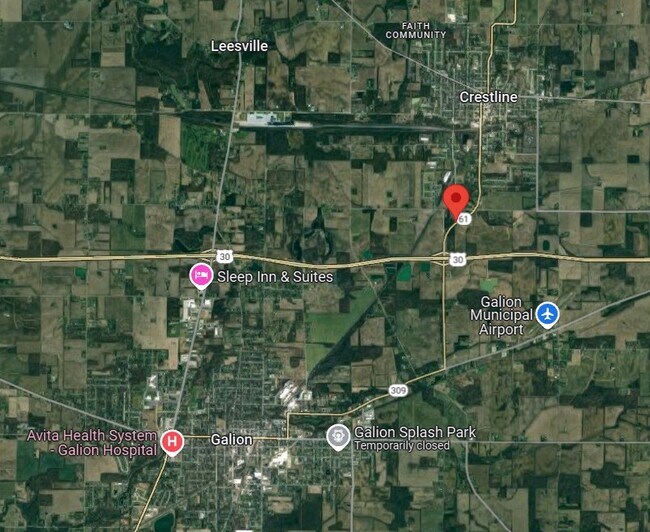
61 Sr, Crestline, OH 44827
Property Detail
61 Sr
Bucyrus, OH
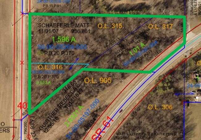
PTNW1/4 BK 1006PG 832 PB 37 P749
50-0005197.004
CRAWFORD
Residentialacreage
Ohio
2025
1.01 AC
2024
Ohio North Area
974800
Other Market Areas
NEARBY LISTINGS FOR SALE OR LEASE
DEMOGRAPHICS near 61 Sr
1 mile
3 mile
5 mile
2025 Total Population
1,083
9,791
21,125
2030 Population
1,090
9,769
21,082
Pop Growth 2025-2030
+ 0.65%
(0.22%)
(0.20%)
Average Age
40
42
43
2025 Total Households
447
4,240
9,053
HH Growth 2025-2030
+ 0.67%
(0.21%)
(0.18%)
Median Household Inc
$40,909
$51,734
$54,235
Avg Household Size
2.40
2.30
2.30
2025 Avg HH Vehicles
2.00
2.00
2.00
Median Home Value
$98,051
$118,537
$135,190
Median Year Built
1965
1960
1959
Nearby Places
Map Layers
Map Styles
 Street
 Aerial
Transit
 Traffic
 Biking
Places
Listings with unknown addresses are not visible on the map
- Restaurants
- Banks
- Shops
- Fitness
- Groceries
SALE & LEASE HISTORY
LISTING DATE
SALE/LEASE

Oct 14, 2024
For Sale
Nearby Properties
Address
Land Use
TOTAL SIZE
Lot Size
Zoning
Address
Land Use
TOTAL SIZE
Lot Size
Zoning
40,615 SF
39.43 AC
Address
Land Use
TOTAL SIZE
Lot Size
Zoning
3.24 AC
Address
Land Use
TOTAL SIZE
Lot Size
Zoning
49.80 AC
Address
Land Use
TOTAL SIZE
Lot Size
Zoning
59.77 AC
Address
Land Use
TOTAL SIZE
Lot Size
Zoning
37,834 SF
2.09 AC
Address
Land Use
TOTAL SIZE
Lot Size
Zoning
73.41 AC
Address
Land Use
TOTAL SIZE
Lot Size
Zoning
7.47 AC
Address
Land Use
TOTAL SIZE
Lot Size
Zoning
Address
Land Use
TOTAL SIZE
Lot Size
Zoning
11,850 SF
3.96 AC
Address
Land Use
TOTAL SIZE
Lot Size
Zoning
17,734 SF
4.44 AC
Address
Land Use
TOTAL SIZE
Lot Size
Zoning
20,502 SF
0.14 AC
Address
Land Use
TOTAL SIZE
Lot Size
Zoning
0.18 AC
Address
Land Use
TOTAL SIZE
Lot Size
Zoning
19,862 SF
9.35 AC
Address
Land Use
TOTAL SIZE
Lot Size
Zoning
23,668 SF
0.32 AC
Address
Land Use
TOTAL SIZE
Lot Size
Zoning
672 SF
4.72 AC
Address
Land Use
TOTAL SIZE
Lot Size
Zoning
Address
Land Use
TOTAL SIZE
Lot Size
Zoning
5.76 AC
Address
Land Use
TOTAL SIZE
Lot Size
Zoning
14,870 SF
2 AC
Address
Land Use
TOTAL SIZE
Lot Size
Zoning
11.24 AC
Address
Land Use
TOTAL SIZE
Lot Size
Zoning
10,220 SF
4.11 AC
Address
Land Use
TOTAL SIZE
Lot Size
Zoning
12,137 SF
0.17 AC
Address
Land Use
TOTAL SIZE
Lot Size
Zoning
4.90 AC
Address
Land Use
TOTAL SIZE
Lot Size
Zoning
23,441 SF
0.17 AC
Address
Land Use
TOTAL SIZE
Lot Size
Zoning
16,665 SF
1.29 AC
Address
Land Use
TOTAL SIZE
Lot Size
Zoning
28.34 AC
Address
Land Use
TOTAL SIZE
Lot Size
Zoning
1.44 AC
Address
Land Use
TOTAL SIZE
Lot Size
Zoning
9.64 AC
Address
Land Use
TOTAL SIZE
Lot Size
Zoning
5.71 AC
Address
Land Use
TOTAL SIZE
Lot Size
Zoning
5,755 SF
0.23 AC
Address
Land Use
TOTAL SIZE
Lot Size
Zoning
696 SF
11.72 AC
The World's #1 Commercial Real Estate Marketplace
Connect with us
© 2026 CoStar Group
The information above has been obtained from sources believed reliable. While we do not doubt its accuracy we have not verified it and make no guarantee, warranty or representation about it. It is your responsibility to independently confirm its accuracy and completeness. Any projections, opinions, assumptions, or estimates used are for example only and do not represent the current or future performance of the property. The value of this transaction to you depends on tax and other factors which should be evaluated by your tax, financial, and legal advisors. You and your advisors should conduct a careful, independent investigation of the property to determine to your satisfaction the suitability of the property for your needs.