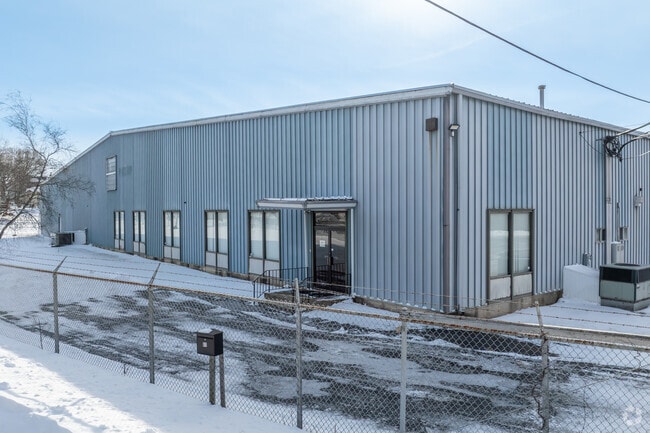
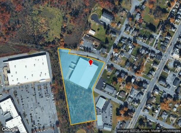
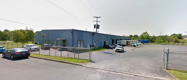
Property Record
61 W 2Nd St, Wind Gap, PA 18091

NEARBY LISTINGS FOR SALE OR LEASE
Property Detail
61 W 2Nd St
Manufacturinglight
Northampton
AE
Pennsylvania
42095C0133E
5.17 AC
2025
Lehigh Valley
2025
Philadelphia
015700
Allentown-Bethlehem-Easton, PA-NJ
50,000 SF
F8NW1D-7-1-0638
DEMOGRAPHICS near 61 W 2Nd St
1 Mile
3 Mile
5 Mile
2024 Total Population
3,085
9,691
27,438
2029 Population
3,096
9,718
27,548
Pop Growth 2024-2029
+ 0.36%
+ 0.28%
+ 0.40%
Average Age
45
43
43
2024 Total Households
1,323
3,948
10,805
HH Growth 2024-2029
+ 0.23%
+ 0.28%
+ 0.47%
Median Household Inc
$53,763
$69,576
$77,642
Avg Household Size
2.20
2.40
2.50
2024 Avg HH Vehicles
2.00
2.00
2.00
Median Home Value
$233,593
$250,000
$260,985
Median Year Built
1967
1963
1969
Nearby Places
- Restaurants
- Banks
- Shops
- Fitness
- Groceries
PUBLIC TRANSPORTATION
AIRPORT
Lehigh Valley International
DRIVE
WALK
Distance
Lehigh Valley International
28 min
17.1 mi
Freight Ports
New York Container Terminal
DRIVE
WALK
Distance
New York Container Terminal
108 min
85.3 mi
SALE & LEASE HISTORY
LISTING DATE
SALE/LEASE

Sep 24, 2016
For Sale
Nov 09, 2023
For Lease
Feb 28, 2020
For Lease
Feb 26, 2018
For Lease
Nearby Properties
Address
Land Use
TOTAL SIZE
Lot Size
Zoning
Address
Land Use
TOTAL SIZE
Lot Size
Zoning
430,352 SF
57.60 AC
GC/I
Address
Land Use
TOTAL SIZE
Lot Size
Zoning
13,872 SF
23.48 AC
IE
Address
Land Use
TOTAL SIZE
Lot Size
Zoning
352,026 SF
1.84 AC
GC/I
Address
Land Use
TOTAL SIZE
Lot Size
Zoning
349,517 SF
28.20 AC
HI
Address
Land Use
TOTAL SIZE
Lot Size
Zoning
42,140 SF
33.11 AC
R10
Address
Land Use
TOTAL SIZE
Lot Size
Zoning
324,240 SF
13.95 AC
HI
Address
Land Use
TOTAL SIZE
Lot Size
Zoning
214,540 SF
25.69 AC
GC/I
Address
Land Use
TOTAL SIZE
Lot Size
Zoning
12,355 SF
2,230.15 AC
E
Address
Land Use
TOTAL SIZE
Lot Size
Zoning
69,548 SF
9.18 AC
GC/I
Address
Land Use
TOTAL SIZE
Lot Size
Zoning
6,200 SF
345.07 AC
FF
Address
Land Use
TOTAL SIZE
Lot Size
Zoning
120,747 SF
22.45 AC
R12
Address
Land Use
TOTAL SIZE
Lot Size
Zoning
55,069 SF
6.77 AC
IC
Address
Land Use
TOTAL SIZE
Lot Size
Zoning
37,164 SF
2.73 AC
HI
Address
Land Use
TOTAL SIZE
Lot Size
Zoning
118,536 SF
14.36 AC
GCI
Address
Land Use
TOTAL SIZE
Lot Size
Zoning
7,704 SF
1.78 AC
R78
Address
Land Use
TOTAL SIZE
Lot Size
Zoning
48,084 SF
7.96 AC
RA
Address
Land Use
TOTAL SIZE
Lot Size
Zoning
34,781 SF
167.39 AC
FF
Address
Land Use
TOTAL SIZE
Lot Size
Zoning
1,050 SF
4.48 AC
PR
Address
Land Use
TOTAL SIZE
Lot Size
Zoning
5,106 SF
60.79 AC
RA
Address
Land Use
TOTAL SIZE
Lot Size
Zoning
18,710 SF
26.90 AC
GC
Address
Land Use
TOTAL SIZE
Lot Size
Zoning
118,536 SF
8.17 AC
GCI
Address
Land Use
TOTAL SIZE
Lot Size
Zoning
92,438 SF
19.14 AC
FF
Address
Land Use
TOTAL SIZE
Lot Size
Zoning
95,160 SF
14.33 AC
IC
Address
Land Use
TOTAL SIZE
Lot Size
Zoning
24,194 SF
2.25 AC
GC/I
Address
Land Use
TOTAL SIZE
Lot Size
Zoning
53,019 SF
3.82 AC
1C
Address
Land Use
TOTAL SIZE
Lot Size
Zoning
346.73 AC
RC
Address
Land Use
TOTAL SIZE
Lot Size
Zoning
5,024 SF
5.31 AC
GC
Address
Land Use
TOTAL SIZE
Lot Size
Zoning
17,500 SF
2.90 AC
IL
Address
Land Use
TOTAL SIZE
Lot Size
Zoning
8,502 SF
6.34 AC
GC
The World's #1 Commercial Real Estate Marketplace
Connect with us
© 2025 CoStar Group
The information above has been obtained from sources believed reliable. While we do not doubt its accuracy we have not verified it and make no guarantee, warranty or representation about it. It is your responsibility to independently confirm its accuracy and completeness. Any projections, opinions, assumptions, or estimates used are for example only and do not represent the current or future performance of the property. The value of this transaction to you depends on tax and other factors which should be evaluated by your tax, financial, and legal advisors. You and your advisors should conduct a careful, independent investigation of the property to determine to your satisfaction the suitability of the property for your needs.