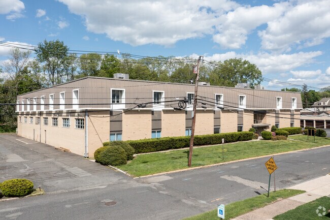
Property Record
61 W Hunter Ave, Maywood, NJ 07607


Save to a Folder
{{folder.Name}}
{{folder.ListingIds.length}} Properties
{{folder.ListingIds.length}} Property
Create a New Folder
Property Detail
61 W Hunter Ave
New York-Jersey City-White Plains, NY-NJ
150X218 PARK
34-00124-0000-00049
Bergen
Commercialnec
New Jersey
LL
49
B and X Area of moderate flood hazard, usually the area between the limits of the 100-year and 500-year floods.
0.75 AC
2025
Route 46 Corridor
2026
Northern New Jersey
033200
NEARBY LISTINGS FOR SALE OR LEASE
DEMOGRAPHICS near 61 W Hunter Ave
1 mile
3 mile
5 mile
2025 Total Population
31,061
211,673
633,004
2030 Population
32,038
216,024
644,623
Pop Growth 2025-2030
+ 3.15%
+ 2.06%
+ 1.84%
Average Age
44
41
40
2025 Total Households
13,187
79,042
221,391
HH Growth 2025-2030
+ 3.28%
+ 2.22%
+ 1.92%
Median Household Inc
$95,437
$98,612
$92,730
Avg Household Size
2.30
2.60
2.70
2025 Avg HH Vehicles
1.00
2.00
2.00
Median Home Value
$442,512
$511,768
$510,702
Median Year Built
1963
1957
1954
Nearby Places
Map Layers
Map Styles
 Street
 Aerial
Layers
 Traffic
 Biking
Places
Listings with unknown addresses are not visible on the map
- Restaurants
- Banks
- Shops
- Fitness
- Groceries
PUBLIC TRANSPORTATION
COMMUTER RAIL
Essex Street (Pascack Valley Line - NJ Transit Commuter Rail (NJ Transit))
Drive
Walk
Distance
Essex Street (Pascack Valley Line - NJ Transit Commuter Rail (NJ Transit))
3 min
1.8 mi
Anderson Street (Pascack Valley Line - NJ Transit Commuter Rail (NJ Transit))
Drive
Walk
Distance
Anderson Street (Pascack Valley Line - NJ Transit Commuter Rail (NJ Transit))
5 min
1.9 mi
AIRPORT
Newark Liberty International
Drive
Walk
Distance
Newark Liberty International
23 min
18.4 mi
LaGuardia
Drive
Walk
Distance
LaGuardia
31 min
19.7 mi
Westchester County
Drive
Walk
Distance
Westchester County
52 min
35.5 mi
Freight Ports
NY - Red Hook Container Terminal
Drive
Walk
Distance
NY - Red Hook Container Terminal
35 min
21.3 mi
SALE & LEASE HISTORY
LISTING DATE
SALE/LEASE

May 24, 2018
For Lease
Jun 07, 2018
For Lease
Jan 08, 2019
For Sale
Dec 11, 2019
For Sale
Aug 09, 2017
For Lease
Apr 12, 2021
For Sale
Nearby Properties
Address
Land Use
TOTAL SIZE
Lot Size
Zoning
Address
Land Use
TOTAL SIZE
Lot Size
Zoning
1,267 SF
0.14 AC
BML
Address
Land Use
TOTAL SIZE
Lot Size
Zoning
Address
Land Use
TOTAL SIZE
Lot Size
Zoning
488,779 SF
7.55 AC
HCS
Address
Land Use
TOTAL SIZE
Lot Size
Zoning
335.71 AC
AF
Address
Land Use
TOTAL SIZE
Lot Size
Zoning
988,414 SF
34.89 AC
BG
Address
Land Use
TOTAL SIZE
Lot Size
Zoning
4.37 AC
HCS
Address
Land Use
TOTAL SIZE
Lot Size
Zoning
378,400 SF
39.30 AC
BML
Address
Land Use
TOTAL SIZE
Lot Size
Zoning
281,720 SF
3.93 AC
R-3
Address
Land Use
TOTAL SIZE
Lot Size
Zoning
512,862 SF
14.16 AC
Address
Land Use
TOTAL SIZE
Lot Size
Zoning
82.74 AC
Address
Land Use
TOTAL SIZE
Lot Size
Zoning
160,036 SF
21.93 AC
R75
Address
Land Use
TOTAL SIZE
Lot Size
Zoning
102,070 SF
29.70 AC
BL
Address
Land Use
TOTAL SIZE
Lot Size
Zoning
8.66 AC
CH1
Address
Land Use
TOTAL SIZE
Lot Size
Zoning
608,596 SF
27.10 AC
LID
Address
Land Use
TOTAL SIZE
Lot Size
Zoning
232,368 SF
5.10 AC
Address
Land Use
TOTAL SIZE
Lot Size
Zoning
30.46 AC
I
Address
Land Use
TOTAL SIZE
Lot Size
Zoning
25,620 SF
21.37 AC
Address
Land Use
TOTAL SIZE
Lot Size
Zoning
197,742 SF
6.20 AC
R3
Address
Land Use
TOTAL SIZE
Lot Size
Zoning
Address
Land Use
TOTAL SIZE
Lot Size
Zoning
250,833 SF
13.49 AC
BG
Address
Land Use
TOTAL SIZE
Lot Size
Zoning
261,303 SF
5.60 AC
O
Address
Land Use
TOTAL SIZE
Lot Size
Zoning
221,229 SF
8.51 AC
LID
Address
Land Use
TOTAL SIZE
Lot Size
Zoning
341,076 SF
40.02 AC
R100
Address
Land Use
TOTAL SIZE
Lot Size
Zoning
303,434 SF
13.34 AC
Address
Land Use
TOTAL SIZE
Lot Size
Zoning
259,273 SF
19.77 AC
BIL
Address
Land Use
TOTAL SIZE
Lot Size
Zoning
Address
Land Use
TOTAL SIZE
Lot Size
Zoning
394,046 SF
1.88 AC
R3
Address
Land Use
TOTAL SIZE
Lot Size
Zoning
2,191 SF
1.34 AC
B2
Address
Land Use
TOTAL SIZE
Lot Size
Zoning
13 AC
B-3
Address
Land Use
TOTAL SIZE
Lot Size
Zoning
31,896 SF
1.64 AC
O
The World's #1 Commercial Real Estate Marketplace
Connect with us
© 2026 CoStar Group
The information above has been obtained from sources believed reliable. While we do not doubt its accuracy we have not verified it and make no guarantee, warranty or representation about it. It is your responsibility to independently confirm its accuracy and completeness. Any projections, opinions, assumptions, or estimates used are for example only and do not represent the current or future performance of the property. The value of this transaction to you depends on tax and other factors which should be evaluated by your tax, financial, and legal advisors. You and your advisors should conduct a careful, independent investigation of the property to determine to your satisfaction the suitability of the property for your needs.