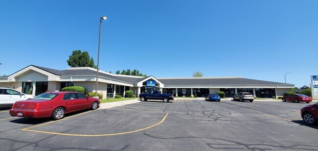
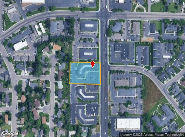
Property Record
620 S Woodruff Ave, Idaho Falls, ID 83401
NEARBY LISTINGS FOR SALE OR LEASE
Property Detail
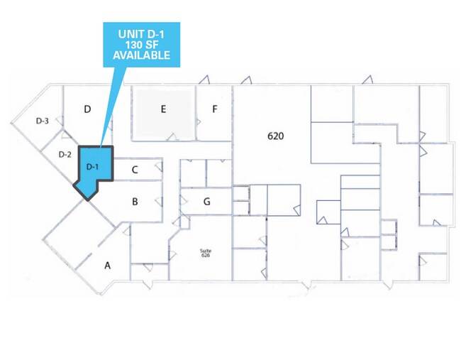
620 S Woodruff Ave
Other Market Areas
Parkwood # 4 Amd # 2
Idaho Falls, ID
LOTS 27-30, BLOCK 2, PARKWOOD # 4 AMENDED # 2 NW1/4, SEC 21, T 2N, R 38
RPA1946002027A
Bonneville
Communitycenter
Idaho
2025
27-30
2025
1.31 AC
970602
Idaho South Area
13,889 SF
DEMOGRAPHICS near 620 S Woodruff Ave
1 Mile
3 Mile
5 Mile
2024 Total Population
17,879
79,741
120,340
2029 Population
20,202
89,948
136,039
Pop Growth 2024-2029
+ 12.99%
+ 12.80%
+ 13.05%
Average Age
36
36
36
2024 Total Households
6,872
28,711
41,655
HH Growth 2024-2029
+ 12.86%
+ 12.73%
+ 12.94%
Median Household Inc
$49,794
$61,940
$69,604
Avg Household Size
2.50
2.70
2.80
2024 Avg HH Vehicles
2.00
2.00
2.00
Median Home Value
$252,738
$297,058
$332,047
Median Year Built
1973
1979
1989
Nearby Places
Map Layers
Map Styles
 Street
 Aerial
- Restaurants
- Banks
- Shops
- Fitness
- Groceries
PUBLIC TRANSPORTATION
AIRPORT
Idaho Falls Regional
DRIVE
WALK
Distance
Idaho Falls Regional
13 min
5.5 mi
Freight Ports
Port of Portland
DRIVE
WALK
Distance
Port of Portland
744 min
712.3 mi
SALE & LEASE HISTORY
LISTING DATE
SALE/LEASE

Sep 30, 2025
For Lease
Sep 25, 2016
For Lease
Sep 01, 2021
For Lease
Mar 30, 2021
For Lease
Jan 27, 2020
For Lease
Feb 02, 2021
For Lease
Dec 14, 2017
For Lease
Aug 04, 2020
For Sale
Apr 02, 2025
For Lease
Nearby Properties
Address
Land Use
TOTAL SIZE
Lot Size
Zoning
Address
Land Use
TOTAL SIZE
Lot Size
Zoning
159,026 SF
13.94 AC
R2
Address
Land Use
TOTAL SIZE
Lot Size
Zoning
375,295 SF
26.11 AC
R2
Address
Land Use
TOTAL SIZE
Lot Size
Zoning
267,740 SF
45.91 AC
Address
Land Use
TOTAL SIZE
Lot Size
Zoning
4,813 SF
13.50 AC
Address
Land Use
TOTAL SIZE
Lot Size
Zoning
4,363 SF
13.28 AC
Address
Land Use
TOTAL SIZE
Lot Size
Zoning
253,387 SF
18.33 AC
R2
Address
Land Use
TOTAL SIZE
Lot Size
Zoning
200,984 SF
10.65 AC
R2
Address
Land Use
TOTAL SIZE
Lot Size
Zoning
10,324 SF
8.73 AC
Address
Land Use
TOTAL SIZE
Lot Size
Zoning
220,179 SF
22.20 AC
R2
Address
Land Use
TOTAL SIZE
Lot Size
Zoning
106,733 SF
2.99 AC
Address
Land Use
TOTAL SIZE
Lot Size
Zoning
1,908 SF
5.77 AC
Address
Land Use
TOTAL SIZE
Lot Size
Zoning
6,300 SF
15.21 AC
Address
Land Use
TOTAL SIZE
Lot Size
Zoning
210,995 SF
24.15 AC
R2
Address
Land Use
TOTAL SIZE
Lot Size
Zoning
800 SF
8.38 AC
Address
Land Use
TOTAL SIZE
Lot Size
Zoning
179,244 SF
16.56 AC
Address
Land Use
TOTAL SIZE
Lot Size
Zoning
5,244 SF
10.78 AC
Address
Land Use
TOTAL SIZE
Lot Size
Zoning
7,617 SF
4.65 AC
Address
Land Use
TOTAL SIZE
Lot Size
Zoning
129,350 SF
4.87 AC
R2
Address
Land Use
TOTAL SIZE
Lot Size
Zoning
6,300 SF
11.42 AC
Address
Land Use
TOTAL SIZE
Lot Size
Zoning
1,472 SF
4.38 AC
Address
Land Use
TOTAL SIZE
Lot Size
Zoning
25,889 SF
2.91 AC
Address
Land Use
TOTAL SIZE
Lot Size
Zoning
98,476 SF
0.66 AC
R2
Address
Land Use
TOTAL SIZE
Lot Size
Zoning
163,776 SF
9.56 AC
R2
Address
Land Use
TOTAL SIZE
Lot Size
Zoning
152,632 SF
7.49 AC
R2
Address
Land Use
TOTAL SIZE
Lot Size
Zoning
4,074 SF
10.06 AC
R2
Address
Land Use
TOTAL SIZE
Lot Size
Zoning
91,002 SF
2.70 AC
R2
Address
Land Use
TOTAL SIZE
Lot Size
Zoning
39,458 SF
7.13 AC
Address
Land Use
TOTAL SIZE
Lot Size
Zoning
93,971 SF
9.38 AC
R2
Address
Land Use
TOTAL SIZE
Lot Size
Zoning
5,584 SF
6.74 AC
Address
Land Use
TOTAL SIZE
Lot Size
Zoning
140,391 SF
17.57 AC
R2
The World's #1 Commercial Real Estate Marketplace
Connect with us
© 2025 CoStar Group
The information above has been obtained from sources believed reliable. While we do not doubt its accuracy we have not verified it and make no guarantee, warranty or representation about it. It is your responsibility to independently confirm its accuracy and completeness. Any projections, opinions, assumptions, or estimates used are for example only and do not represent the current or future performance of the property. The value of this transaction to you depends on tax and other factors which should be evaluated by your tax, financial, and legal advisors. You and your advisors should conduct a careful, independent investigation of the property to determine to your satisfaction the suitability of the property for your needs.