Property Record
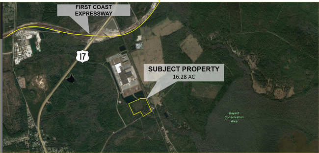
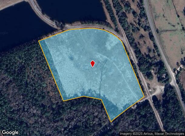
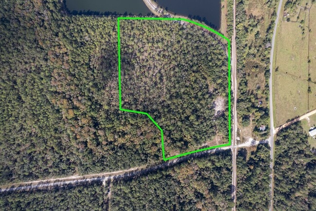
County Road 226, Green Cove Springs, FL 32043
NEARBY LISTINGS FOR SALE OR LEASE
Property Detail
County Road 226
Jacksonville, FL
Bayard Tract
38-06-26-016518-000-00
PT BLKS 26;27;31;35;36 & SEC 18 E HWY 17;ALL BLK 37 N OF FRIES LINE & PT BLK 30 N OF FRIES
Commercialacreage
Clay
A
Florida
12109C0250J
16.28 AC
2024
Orange Park/Clay County
2025
Jacksonville (Florida)
031302
DEMOGRAPHICS near County Road 226
1 Mile
3 Mile
5 Mile
2024 Total Population
41
1,611
10,256
2029 Population
45
1,757
11,240
Pop Growth 2024-2029
+ 9.76%
+ 9.06%
+ 9.59%
Average Age
45
45
43
2024 Total Households
16
635
3,890
HH Growth 2024-2029
+ 6.25%
+ 8.98%
+ 9.56%
Median Household Inc
$59,999
$65,281
$60,667
Avg Household Size
2.40
2.50
2.50
2024 Avg HH Vehicles
2.00
2.00
2.00
Median Home Value
$366,666
$378,712
$313,542
Median Year Built
1993
1991
1986
Nearby Places
- Restaurants
- Banks
- Shops
- Fitness
- Groceries
SALE & LEASE HISTORY
LISTING DATE
SALE/LEASE

Oct 27, 2021
For Sale
Jan 08, 2024
For Sale
Nearby Properties
Address
Land Use
TOTAL SIZE
Lot Size
Zoning
Address
Land Use
TOTAL SIZE
Lot Size
Zoning
787,824 SF
137.13 AC
Address
Land Use
TOTAL SIZE
Lot Size
Zoning
705,382 SF
1,544.26 AC
M-2
Address
Land Use
TOTAL SIZE
Lot Size
Zoning
1,000 SF
3,464.66 AC
Address
Land Use
TOTAL SIZE
Lot Size
Zoning
349.57 AC
Address
Land Use
TOTAL SIZE
Lot Size
Zoning
9,936 SF
1,615.34 AC
IS
Address
Land Use
TOTAL SIZE
Lot Size
Zoning
111,941 SF
27.29 AC
Address
Land Use
TOTAL SIZE
Lot Size
Zoning
66,000 SF
9.20 AC
Address
Land Use
TOTAL SIZE
Lot Size
Zoning
1,047.66 AC
Address
Land Use
TOTAL SIZE
Lot Size
Zoning
Address
Land Use
TOTAL SIZE
Lot Size
Zoning
74,000 SF
7.01 AC
Address
Land Use
TOTAL SIZE
Lot Size
Zoning
1,068 SF
67.49 AC
Address
Land Use
TOTAL SIZE
Lot Size
Zoning
108,726 SF
7.46 AC
IB
Address
Land Use
TOTAL SIZE
Lot Size
Zoning
114,185 SF
30.51 AC
IB
Address
Land Use
TOTAL SIZE
Lot Size
Zoning
31.23 AC
IB
Address
Land Use
TOTAL SIZE
Lot Size
Zoning
Address
Land Use
TOTAL SIZE
Lot Size
Zoning
34.99 AC
IB
Address
Land Use
TOTAL SIZE
Lot Size
Zoning
61,361 SF
23.37 AC
Address
Land Use
TOTAL SIZE
Lot Size
Zoning
96.08 AC
C-2
Address
Land Use
TOTAL SIZE
Lot Size
Zoning
123,749 SF
51.18 AC
IB
Address
Land Use
TOTAL SIZE
Lot Size
Zoning
8,531 SF
41.49 AC
Address
Land Use
TOTAL SIZE
Lot Size
Zoning
9,936 SF
39.72 AC
PS-2
Address
Land Use
TOTAL SIZE
Lot Size
Zoning
24.17 AC
MUH
Address
Land Use
TOTAL SIZE
Lot Size
Zoning
44,324 SF
4.81 AC
IB
Address
Land Use
TOTAL SIZE
Lot Size
Zoning
305.97 AC
Address
Land Use
TOTAL SIZE
Lot Size
Zoning
34,202 SF
5.74 AC
IB
Address
Land Use
TOTAL SIZE
Lot Size
Zoning
383.90 AC
Address
Land Use
TOTAL SIZE
Lot Size
Zoning
619.76 AC
Address
Land Use
TOTAL SIZE
Lot Size
Zoning
10,640 SF
8,842.95 AC
BA
Address
Land Use
TOTAL SIZE
Lot Size
Zoning
The World's #1 Commercial Real Estate Marketplace
Connect with us
© 2025 CoStar Group
The information above has been obtained from sources believed reliable. While we do not doubt its accuracy we have not verified it and make no guarantee, warranty or representation about it. It is your responsibility to independently confirm its accuracy and completeness. Any projections, opinions, assumptions, or estimates used are for example only and do not represent the current or future performance of the property. The value of this transaction to you depends on tax and other factors which should be evaluated by your tax, financial, and legal advisors. You and your advisors should conduct a careful, independent investigation of the property to determine to your satisfaction the suitability of the property for your needs.