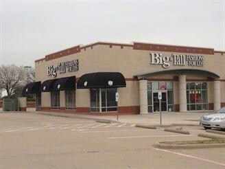
Property Record
610 E Flower Mound Rd, Flower Mound, TX 75028

Property Detail
610 E Flower Mound Rd
Dallas-Fort Worth-Arlington, TX
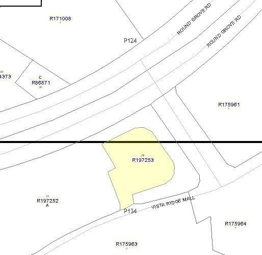
VISTA RIDGE MALL BLK A LOT 2B
R197253
DENTON
Commercialnec
Texas
B and X Area of moderate flood hazard, usually the area between the limits of the 100-year and 500-year floods.
2b
2024
0.40 AC
2025
Lewisville
021722
Dallas/Ft Worth
3,000 SF
NEARBY LISTINGS FOR SALE OR LEASE
DEMOGRAPHICS near 610 E Flower Mound Rd
1 mile
3 mile
5 mile
2024 Total Population
17,847
99,237
249,694
2029 Population
19,884
107,796
272,400
Pop Growth 2024-2029
+ 11.41%
+ 8.62%
+ 9.09%
Average Age
36
37
38
2024 Total Households
8,916
39,197
94,525
HH Growth 2024-2029
+ 11.66%
+ 9.22%
+ 9.06%
Median Household Inc
$73,881
$94,354
$103,418
Avg Household Size
2.00
2.50
2.60
2024 Avg HH Vehicles
2.00
2.00
2.00
Median Home Value
$430,897
$437,204
$443,174
Median Year Built
1999
1995
1994
Nearby Places
Map Layers
Map Styles
 Street
 Aerial
Transit
 Traffic
 Biking
Places
Listings with unknown addresses are not visible on the map
- Restaurants
- Banks
- Shops
- Fitness
- Groceries
PUBLIC TRANSPORTATION
COMMUTER RAIL
Hebron Station (A-train - Denton County Transportation Authority)
Drive
Walk
Distance
Hebron Station (A-train - Denton County Transportation Authority)
4 min
1.2 mi
Old Town Station (A-train - Denton County Transportation Authority)
Drive
Walk
Distance
Old Town Station (A-train - Denton County Transportation Authority)
7 min
3.9 mi
AIRPORT
Dallas-Fort Worth International
Drive
Walk
Distance
Dallas-Fort Worth International
15 min
10.7 mi
Dallas Love Field
Drive
Walk
Distance
Dallas Love Field
26 min
17.9 mi
Freight Ports
Port of Shreveport
Drive
Walk
Distance
Port of Shreveport
233 min
215.5 mi
Nearby Properties
Address
Land Use
TOTAL SIZE
Lot Size
Zoning
Address
Land Use
TOTAL SIZE
Lot Size
Zoning
481,511 SF
34.76 AC
Z172
Address
Land Use
TOTAL SIZE
Lot Size
Zoning
660,180 SF
29.95 AC
Address
Land Use
TOTAL SIZE
Lot Size
Zoning
462,692 SF
30.77 AC
2G
Address
Land Use
TOTAL SIZE
Lot Size
Zoning
835,344 SF
143.50 AC
Address
Land Use
TOTAL SIZE
Lot Size
Zoning
452,167 SF
5.80 AC
Address
Land Use
TOTAL SIZE
Lot Size
Zoning
242,707 SF
27.63 AC
Z343
Address
Land Use
TOTAL SIZE
Lot Size
Zoning
352,209 SF
17.54 AC
Z172
Address
Land Use
TOTAL SIZE
Lot Size
Zoning
394,048 SF
16.36 AC
Address
Land Use
TOTAL SIZE
Lot Size
Zoning
379,940 SF
63.48 AC
Z31
Address
Land Use
TOTAL SIZE
Lot Size
Zoning
382,330 SF
21.43 AC
3B
Address
Land Use
TOTAL SIZE
Lot Size
Zoning
385,247 SF
22.59 AC
3B
Address
Land Use
TOTAL SIZE
Lot Size
Zoning
344,868 SF
19.44 AC
Address
Land Use
TOTAL SIZE
Lot Size
Zoning
514,192 SF
21.56 AC
3B
Address
Land Use
TOTAL SIZE
Lot Size
Zoning
412,389 SF
16.69 AC
3B
Address
Land Use
TOTAL SIZE
Lot Size
Zoning
354,546 SF
19.38 AC
3B
Address
Land Use
TOTAL SIZE
Lot Size
Zoning
424,064 SF
22.15 AC
2B
Address
Land Use
TOTAL SIZE
Lot Size
Zoning
947,236 SF
52.19 AC
Address
Land Use
TOTAL SIZE
Lot Size
Zoning
411,223 SF
24.07 AC
3B
Address
Land Use
TOTAL SIZE
Lot Size
Zoning
1,030,000 SF
53.43 AC
Address
Land Use
TOTAL SIZE
Lot Size
Zoning
344,926 SF
19.93 AC
3B
Address
Land Use
TOTAL SIZE
Lot Size
Zoning
347,181 SF
18.51 AC
3B
Address
Land Use
TOTAL SIZE
Lot Size
Zoning
392,646 SF
19.65 AC
3B
Address
Land Use
TOTAL SIZE
Lot Size
Zoning
297,932 SF
14.05 AC
Address
Land Use
TOTAL SIZE
Lot Size
Zoning
330,816 SF
14.97 AC
Address
Land Use
TOTAL SIZE
Lot Size
Zoning
310,788 SF
15.05 AC
Address
Land Use
TOTAL SIZE
Lot Size
Zoning
315,084 SF
13.76 AC
3B
Address
Land Use
TOTAL SIZE
Lot Size
Zoning
295,668 SF
13.03 AC
Address
Land Use
TOTAL SIZE
Lot Size
Zoning
659,218 SF
34.29 AC
Address
Land Use
TOTAL SIZE
Lot Size
Zoning
251,650 SF
14.22 AC
Address
Land Use
TOTAL SIZE
Lot Size
Zoning
318,477 SF
18.79 AC
The World's #1 Commercial Real Estate Marketplace
Connect with us
© 2026 CoStar Group
The information above has been obtained from sources believed reliable. While we do not doubt its accuracy we have not verified it and make no guarantee, warranty or representation about it. It is your responsibility to independently confirm its accuracy and completeness. Any projections, opinions, assumptions, or estimates used are for example only and do not represent the current or future performance of the property. The value of this transaction to you depends on tax and other factors which should be evaluated by your tax, financial, and legal advisors. You and your advisors should conduct a careful, independent investigation of the property to determine to your satisfaction the suitability of the property for your needs.