Property Record
610 E Malloy Bridge Rd, Seagoville, TX 75159


NEARBY LISTINGS FOR SALE OR LEASE
Property Detail
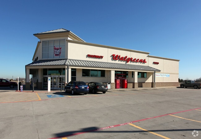
610 E Malloy Bridge Rd
Dallas-Fort Worth-Arlington, TX
Walgreens
50050010010010000
WALGREENS BLK 1 LT 1 LESS ROW ACS 1.8925 INT202100370631 DD12102021 CO-DC 0500100100100 4CJ05001001
Storebuilding
Dallas
X
Texas
48257C0150E
1
2024
1.89 AC
2025
Southeast Outlying
017008
Dallas/Ft Worth
14,838 SF
DEMOGRAPHICS near 610 E Malloy Bridge Rd
1 Mile
3 Mile
5 Mile
2024 Total Population
5,809
16,106
52,118
2029 Population
5,723
16,166
55,917
Pop Growth 2024-2029
(1.48%)
+ 0.37%
+ 7.29%
Average Age
37
36
33
2024 Total Households
1,745
4,493
14,757
HH Growth 2024-2029
(1.72%)
+ 0.36%
+ 7.87%
Median Household Inc
$57,856
$53,404
$58,026
Avg Household Size
3.10
3.20
3.30
2024 Avg HH Vehicles
2.00
2.00
2.00
Median Home Value
$191,441
$188,645
$198,460
Median Year Built
1992
1992
2001
Nearby Places
Map Layers
Map Styles
 Street
 Aerial
- Restaurants
- Banks
- Shops
- Fitness
- Groceries
PUBLIC TRANSPORTATION
AIRPORT
Dallas Love Field
DRIVE
WALK
Distance
Dallas Love Field
35 min
24.7 mi
Dallas-Fort Worth International
DRIVE
WALK
Distance
Dallas-Fort Worth International
50 min
40.6 mi
Nearby Properties
Address
Land Use
TOTAL SIZE
Lot Size
Zoning
Address
Land Use
TOTAL SIZE
Lot Size
Zoning
361,155 SF
14.64 AC
Z308
Address
Land Use
TOTAL SIZE
Lot Size
Zoning
106,462 SF
9.58 AC
Z236
Address
Land Use
TOTAL SIZE
Lot Size
Zoning
377,133 SF
16.71 AC
Z131
Address
Land Use
TOTAL SIZE
Lot Size
Zoning
88,320 SF
4.48 AC
Z72
Address
Land Use
TOTAL SIZE
Lot Size
Zoning
216,327 SF
26.31 AC
Address
Land Use
TOTAL SIZE
Lot Size
Zoning
319 SF
37.74 AC
SUP1
Address
Land Use
TOTAL SIZE
Lot Size
Zoning
172,068 SF
17.25 AC
Z137
Address
Land Use
TOTAL SIZE
Lot Size
Zoning
28,126 SF
166.45 AC
Z05
Address
Land Use
TOTAL SIZE
Lot Size
Zoning
19,641 SF
4.37 AC
Z236
Address
Land Use
TOTAL SIZE
Lot Size
Zoning
83,266 SF
6.73 AC
Z131
Address
Land Use
TOTAL SIZE
Lot Size
Zoning
100,200 SF
6.93 AC
Z05
Address
Land Use
TOTAL SIZE
Lot Size
Zoning
108 SF
14.44 AC
Z31
Address
Land Use
TOTAL SIZE
Lot Size
Zoning
65,577 SF
11.80 AC
Z31
Address
Land Use
TOTAL SIZE
Lot Size
Zoning
75,908 SF
11.11 AC
Z308
Address
Land Use
TOTAL SIZE
Lot Size
Zoning
53,449 SF
20.04 AC
Z308
Address
Land Use
TOTAL SIZE
Lot Size
Zoning
92 SF
11.39 AC
SUP12
Address
Land Use
TOTAL SIZE
Lot Size
Zoning
94,615 SF
3.34 AC
Z399
Address
Land Use
TOTAL SIZE
Lot Size
Zoning
51,770 SF
7.61 AC
Z31
Address
Land Use
TOTAL SIZE
Lot Size
Zoning
10,010 SF
1.50 AC
Z137
Address
Land Use
TOTAL SIZE
Lot Size
Zoning
19,670 SF
1.95 AC
Z137
Address
Land Use
TOTAL SIZE
Lot Size
Zoning
12,684 SF
3.51 AC
Z137
Address
Land Use
TOTAL SIZE
Lot Size
Zoning
64,420 SF
8.91 AC
Z131
Address
Land Use
TOTAL SIZE
Lot Size
Zoning
28,000 SF
4.66 AC
Z308
Address
Land Use
TOTAL SIZE
Lot Size
Zoning
22,870 SF
1.15 AC
Z31
Address
Land Use
TOTAL SIZE
Lot Size
Zoning
43,000 SF
4.30 AC
Z05
Address
Land Use
TOTAL SIZE
Lot Size
Zoning
0.01 AC
Z306
Address
Land Use
TOTAL SIZE
Lot Size
Zoning
52,480 SF
103.55 AC
Address
Land Use
TOTAL SIZE
Lot Size
Zoning
20,400 SF
1.99 AC
Z137
Address
Land Use
TOTAL SIZE
Lot Size
Zoning
50,872 SF
4.99 AC
Z137
Address
Land Use
TOTAL SIZE
Lot Size
Zoning
60 SF
7.22 AC
Z399
The World's #1 Commercial Real Estate Marketplace
Connect with us
© 2026 CoStar Group
The information above has been obtained from sources believed reliable. While we do not doubt its accuracy we have not verified it and make no guarantee, warranty or representation about it. It is your responsibility to independently confirm its accuracy and completeness. Any projections, opinions, assumptions, or estimates used are for example only and do not represent the current or future performance of the property. The value of this transaction to you depends on tax and other factors which should be evaluated by your tax, financial, and legal advisors. You and your advisors should conduct a careful, independent investigation of the property to determine to your satisfaction the suitability of the property for your needs.