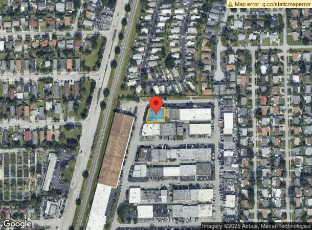
Property Record
610 Ne 29Th St, Pompano Beach, FL 33064


Current Lease Availabilities
NEARBY LISTINGS FOR SALE OR LEASE
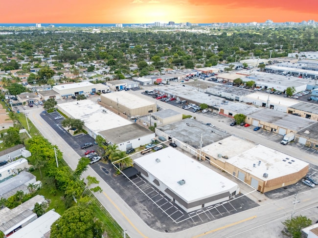
Property Detail
610 Ne 29Th St
Fort Lauderdale-Pompano Beach-Deerfield Beach, FL
East Coast Industrial Center
48-42-24-27-0210
EAST COAST INDUSTRIAL CENTER 63-30 B LOT 20
Warehouse
Broward
X
Florida
12011C0188J
20
2024
0.26 AC
2025
Pompano Beach
030201
South Florida
7,602 SF
DEMOGRAPHICS near 610 Ne 29Th St
1 Mile
3 Mile
5 Mile
2024 Total Population
16,612
127,859
296,770
2029 Population
16,270
128,347
300,597
Pop Growth 2024-2029
(2.06%)
+ 0.38%
+ 1.29%
Average Age
39
42
46
2024 Total Households
5,810
52,504
132,222
HH Growth 2024-2029
(2.55%)
+ 0.47%
+ 1.54%
Median Household Inc
$53,451
$56,634
$59,163
Avg Household Size
2.60
2.30
2.10
2024 Avg HH Vehicles
2.00
2.00
1.00
Median Home Value
$243,572
$320,127
$323,767
Median Year Built
1967
1974
1977
Nearby Places
Map Layers
Map Styles
 Street
 Aerial
- Restaurants
- Banks
- Shops
- Fitness
- Groceries
PUBLIC TRANSPORTATION
COMMUTER RAIL
Pompano Beach (Tri-County Commuter - South Florida Regional Transportation Authority (Tri-Rail))
DRIVE
WALK
Distance
Pompano Beach (Tri-County Commuter - South Florida Regional Transportation Authority (Tri-Rail))
8 min
2.9 mi
Deerfield Beach (Tri-County Commuter - South Florida Regional Transportation Authority (Tri-Rail))
DRIVE
WALK
Distance
Deerfield Beach (Tri-County Commuter - South Florida Regional Transportation Authority (Tri-Rail))
13 min
6.1 mi
AIRPORT
Fort Lauderdale/Hollywood International
DRIVE
WALK
Distance
Fort Lauderdale/Hollywood International
28 min
18.0 mi
Palm Beach International
DRIVE
WALK
Distance
Palm Beach International
46 min
34.2 mi
Miami International
DRIVE
WALK
Distance
Miami International
64 min
43.2 mi
Freight Ports
Port Everglades
DRIVE
WALK
Distance
Port Everglades
27 min
16.7 mi
Nearby Properties
Address
Land Use
TOTAL SIZE
Lot Size
Zoning
Address
Land Use
TOTAL SIZE
Lot Size
Zoning
696,020 SF
31.74 AC
OPC
Address
Land Use
TOTAL SIZE
Lot Size
Zoning
1,166,083 SF
74.07 AC
I
Address
Land Use
TOTAL SIZE
Lot Size
Zoning
513,748 SF
2.99 AC
TO-EOD
Address
Land Use
TOTAL SIZE
Lot Size
Zoning
484,380 SF
137.82 AC
T
Address
Land Use
TOTAL SIZE
Lot Size
Zoning
467,722 SF
36.71 AC
I-1
Address
Land Use
TOTAL SIZE
Lot Size
Zoning
285,335 SF
8.56 AC
RM-45
Address
Land Use
TOTAL SIZE
Lot Size
Zoning
184,184 SF
2.98 AC
RM-45/HR
Address
Land Use
TOTAL SIZE
Lot Size
Zoning
392,222 SF
5.33 AC
RPUD
Address
Land Use
TOTAL SIZE
Lot Size
Zoning
406,839 SF
1.61 AC
RPUD
Address
Land Use
TOTAL SIZE
Lot Size
Zoning
161,512 SF
16.39 AC
RPC
Address
Land Use
TOTAL SIZE
Lot Size
Zoning
434,859 SF
38.72 AC
CF
Address
Land Use
TOTAL SIZE
Lot Size
Zoning
399,854 SF
1.60 AC
TO-EOD
Address
Land Use
TOTAL SIZE
Lot Size
Zoning
380,866 SF
26.23 AC
O-IP/PCD
Address
Land Use
TOTAL SIZE
Lot Size
Zoning
374,776 SF
23.52 AC
I-1
Address
Land Use
TOTAL SIZE
Lot Size
Zoning
435,201 SF
23.78 AC
I-1
Address
Land Use
TOTAL SIZE
Lot Size
Zoning
313,030 SF
37.22 AC
CF
Address
Land Use
TOTAL SIZE
Lot Size
Zoning
192,214 SF
10.84 AC
B-3/PCD
Address
Land Use
TOTAL SIZE
Lot Size
Zoning
283,330 SF
27.02 AC
I-1/PCI
Address
Land Use
TOTAL SIZE
Lot Size
Zoning
171,306 SF
0.81 AC
TO-EOD
Address
Land Use
TOTAL SIZE
Lot Size
Zoning
247,079 SF
14.66 AC
I
Address
Land Use
TOTAL SIZE
Lot Size
Zoning
159,618 SF
77.09 AC
PU
Address
Land Use
TOTAL SIZE
Lot Size
Zoning
244,452 SF
13.10 AC
RM-20
Address
Land Use
TOTAL SIZE
Lot Size
Zoning
224,769 SF
15.48 AC
I-1
Address
Land Use
TOTAL SIZE
Lot Size
Zoning
249,657 SF
17.49 AC
I-1/PCD
Address
Land Use
TOTAL SIZE
Lot Size
Zoning
260,464 SF
14.82 AC
PUD
Address
Land Use
TOTAL SIZE
Lot Size
Zoning
389,735 SF
28.12 AC
CF
Address
Land Use
TOTAL SIZE
Lot Size
Zoning
222,660 SF
18.22 AC
CF
Address
Land Use
TOTAL SIZE
Lot Size
Zoning
152,273 SF
20.03 AC
B-3
Address
Land Use
TOTAL SIZE
Lot Size
Zoning
144,205 SF
5 AC
RM-25
Address
Land Use
TOTAL SIZE
Lot Size
Zoning
153,579 SF
31 AC
I-1
The World's #1 Commercial Real Estate Marketplace
Connect with us
© 2025 CoStar Group
The information above has been obtained from sources believed reliable. While we do not doubt its accuracy we have not verified it and make no guarantee, warranty or representation about it. It is your responsibility to independently confirm its accuracy and completeness. Any projections, opinions, assumptions, or estimates used are for example only and do not represent the current or future performance of the property. The value of this transaction to you depends on tax and other factors which should be evaluated by your tax, financial, and legal advisors. You and your advisors should conduct a careful, independent investigation of the property to determine to your satisfaction the suitability of the property for your needs.