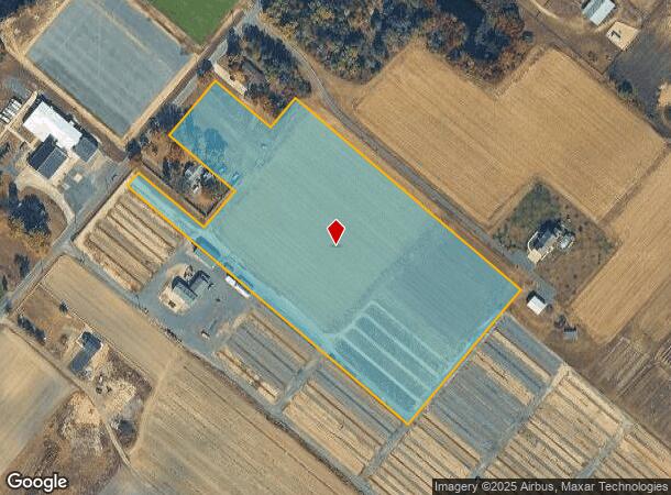
Property Record
610 Pine Rd, Hammonton, NJ 08037


NEARBY LISTINGS FOR SALE OR LEASE
-
-
View all Hammonton listings for sale on LoopNet.com
Property Detail
610 Pine Rd
Atlantic City-Hammonton, NJ
Atlantic
13-05101-0000-00020
B182L18
Farms
Atlantic
X
New Jersey
34001C0017F
20
2024
10 AC
2025
Atlantic City/Hammonton
010800
Philadelphia
DEMOGRAPHICS near 610 Pine Rd
1 Mile
3 Mile
5 Mile
2024 Total Population
351
9,263
16,884
2029 Population
343
9,003
16,468
Pop Growth 2024-2029
(2.28%)
(2.81%)
(2.46%)
Average Age
42
41
42
2024 Total Households
125
3,412
6,053
HH Growth 2024-2029
(3.20%)
(3.52%)
(3.11%)
Median Household Inc
$58,333
$71,785
$80,173
Avg Household Size
2.50
2.60
2.60
2024 Avg HH Vehicles
2.00
2.00
2.00
Median Home Value
$274,999
$276,511
$268,550
Median Year Built
1978
1973
1971
Nearby Places
Map Layers
Map Styles
 Street
 Aerial
- Restaurants
- Banks
- Shops
- Fitness
- Groceries
PUBLIC TRANSPORTATION
COMMUTER RAIL
Hammonton (Atlantic City Line - NJ Transit Commuter Rail (NJ Transit))
DRIVE
WALK
Distance
Hammonton (Atlantic City Line - NJ Transit Commuter Rail (NJ Transit))
8 min
4.3 mi
AIRPORT
Atlantic City International
DRIVE
WALK
Distance
Atlantic City International
52 min
23.7 mi
Philadelphia International
DRIVE
WALK
Distance
Philadelphia International
56 min
37.3 mi
Freight Ports
Broadway Terminal - Pier 5
DRIVE
WALK
Distance
Broadway Terminal - Pier 5
41 min
28.8 mi
SALE & LEASE HISTORY
LISTING DATE
SALE/LEASE

Mar 22, 2023
For Sale
Nearby Properties
Address
Land Use
TOTAL SIZE
Lot Size
Zoning
Address
Land Use
TOTAL SIZE
Lot Size
Zoning
50.38 AC
Address
Land Use
TOTAL SIZE
Lot Size
Zoning
28.33 AC
R-3
Address
Land Use
TOTAL SIZE
Lot Size
Zoning
43.26 AC
R-1
Address
Land Use
TOTAL SIZE
Lot Size
Zoning
3,500 SF
4.77 AC
Address
Land Use
TOTAL SIZE
Lot Size
Zoning
Address
Land Use
TOTAL SIZE
Lot Size
Zoning
2,528 SF
21.85 AC
Address
Land Use
TOTAL SIZE
Lot Size
Zoning
Address
Land Use
TOTAL SIZE
Lot Size
Zoning
Address
Land Use
TOTAL SIZE
Lot Size
Zoning
14.85 AC
Address
Land Use
TOTAL SIZE
Lot Size
Zoning
Address
Land Use
TOTAL SIZE
Lot Size
Zoning
16.92 AC
Address
Land Use
TOTAL SIZE
Lot Size
Zoning
67,563 SF
13.73 AC
Address
Land Use
TOTAL SIZE
Lot Size
Zoning
0.92 AC
Address
Land Use
TOTAL SIZE
Lot Size
Zoning
Address
Land Use
TOTAL SIZE
Lot Size
Zoning
43,282 SF
1.58 AC
Address
Land Use
TOTAL SIZE
Lot Size
Zoning
26,277 SF
1 AC
Address
Land Use
TOTAL SIZE
Lot Size
Zoning
2,190 SF
7.20 AC
Address
Land Use
TOTAL SIZE
Lot Size
Zoning
Address
Land Use
TOTAL SIZE
Lot Size
Zoning
10,520 SF
7.76 AC
Address
Land Use
TOTAL SIZE
Lot Size
Zoning
7.14 AC
R-1
Address
Land Use
TOTAL SIZE
Lot Size
Zoning
Address
Land Use
TOTAL SIZE
Lot Size
Zoning
12,580 SF
9.89 AC
R-1
Address
Land Use
TOTAL SIZE
Lot Size
Zoning
34,074 SF
3.43 AC
Address
Land Use
TOTAL SIZE
Lot Size
Zoning
Address
Land Use
TOTAL SIZE
Lot Size
Zoning
16,731 SF
0.71 AC
Address
Land Use
TOTAL SIZE
Lot Size
Zoning
10,740 SF
0.84 AC
Address
Land Use
TOTAL SIZE
Lot Size
Zoning
Address
Land Use
TOTAL SIZE
Lot Size
Zoning
13,698 SF
2.25 AC
Address
Land Use
TOTAL SIZE
Lot Size
Zoning
0.67 AC
Address
Land Use
TOTAL SIZE
Lot Size
Zoning
0.67 AC
The World's #1 Commercial Real Estate Marketplace
Connect with us
© 2026 CoStar Group
The information above has been obtained from sources believed reliable. While we do not doubt its accuracy we have not verified it and make no guarantee, warranty or representation about it. It is your responsibility to independently confirm its accuracy and completeness. Any projections, opinions, assumptions, or estimates used are for example only and do not represent the current or future performance of the property. The value of this transaction to you depends on tax and other factors which should be evaluated by your tax, financial, and legal advisors. You and your advisors should conduct a careful, independent investigation of the property to determine to your satisfaction the suitability of the property for your needs.