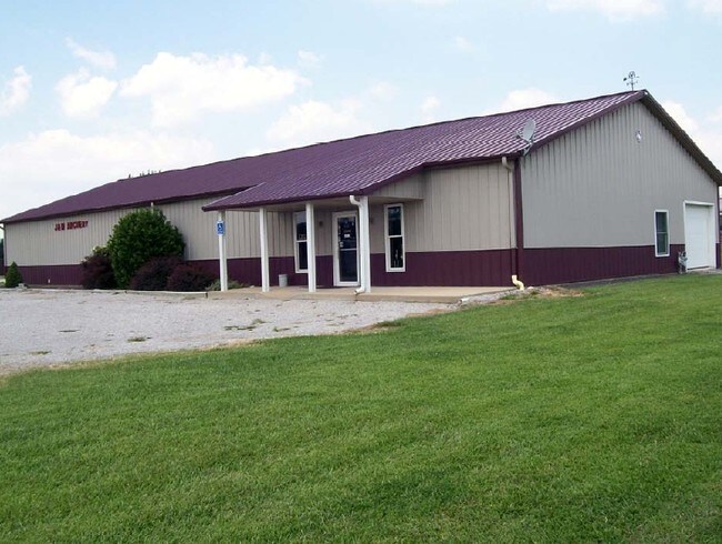
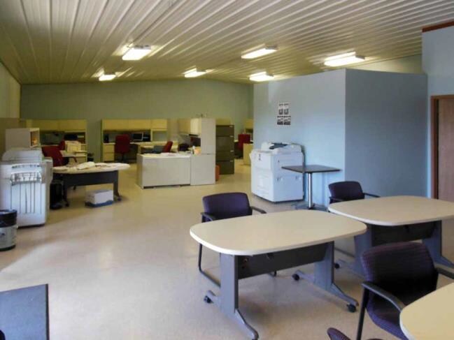
Property Record
610 S Meyer Ave, Valmeyer, IL 62295

Property Detail
610 S Meyer Ave
09-02-281-003-000
LOT IND 3 NEW VALMEYER PHASE 1
Industrialgeneral
Monroe
VB2
Illinois
B and X Area of moderate flood hazard, usually the area between the limits of the 100-year and 500-year floods.
0.88 AC
2024
Monroe County
2024
St. Louis
600402
St. Louis, MO-IL
NEARBY LISTINGS FOR SALE OR LEASE
-
-
View all Valmeyer listings for sale on LoopNet.com
DEMOGRAPHICS near 610 S Meyer Ave
1 mile
3 mile
5 mile
2025 Total Population
1,105
1,679
2,988
2030 Population
1,096
1,669
2,968
Pop Growth 2025-2030
(0.81%)
(0.60%)
(0.67%)
Average Age
40
41
42
2025 Total Households
406
625
1,128
HH Growth 2025-2030
(0.74%)
(0.64%)
(0.62%)
Median Household Inc
$90,833
$93,676
$92,956
Avg Household Size
2.70
2.70
2.60
2025 Avg HH Vehicles
3.00
3.00
3.00
Median Home Value
$219,366
$237,623
$254,388
Median Year Built
1997
1996
1994
Nearby Places
Map Layers
Map Styles
 Street
 Aerial
Layers
 Traffic
 Biking
Places
Listings with unknown addresses are not visible on the map
- Restaurants
- Banks
- Shops
- Fitness
- Groceries
PUBLIC TRANSPORTATION
AIRPORT
Scott AFB/Midamerica St Louis
Drive
Walk
Distance
Scott AFB/Midamerica St Louis
66 min
38.1 mi
Freight Ports
Tulsa Port of Inola
Drive
Walk
Distance
Tulsa Port of Inola
449 min
400.8 mi
Nearby Properties
Address
Land Use
TOTAL SIZE
Lot Size
Zoning
Address
Land Use
TOTAL SIZE
Lot Size
Zoning
Address
Land Use
TOTAL SIZE
Lot Size
Zoning
Address
Land Use
TOTAL SIZE
Lot Size
Zoning
8.90 AC
VI1
Address
Land Use
TOTAL SIZE
Lot Size
Zoning
Address
Land Use
TOTAL SIZE
Lot Size
Zoning
1.55 AC
VI1
Address
Land Use
TOTAL SIZE
Lot Size
Zoning
1.54 AC
VI1
Address
Land Use
TOTAL SIZE
Lot Size
Zoning
0.64 AC
VB1
Address
Land Use
TOTAL SIZE
Lot Size
Zoning
1,530 SF
11.36 AC
MA1
Address
Land Use
TOTAL SIZE
Lot Size
Zoning
3,628 SF
20 AC
MA1
Address
Land Use
TOTAL SIZE
Lot Size
Zoning
3,382 SF
5 AC
MR2
Address
Land Use
TOTAL SIZE
Lot Size
Zoning
1.41 AC
MB2
Address
Land Use
TOTAL SIZE
Lot Size
Zoning
1.50 AC
VB2
Address
Land Use
TOTAL SIZE
Lot Size
Zoning
2,160 SF
3.06 AC
VI1
Address
Land Use
TOTAL SIZE
Lot Size
Zoning
2,565 SF
0.85 AC
VB2
Address
Land Use
TOTAL SIZE
Lot Size
Zoning
1.05 AC
VB2
Address
Land Use
TOTAL SIZE
Lot Size
Zoning
0.16 AC
VR3
Address
Land Use
TOTAL SIZE
Lot Size
Zoning
20.60 AC
MA1
Address
Land Use
TOTAL SIZE
Lot Size
Zoning
0.22 AC
VR4
Address
Land Use
TOTAL SIZE
Lot Size
Zoning
3.46 AC
VI1
Address
Land Use
TOTAL SIZE
Lot Size
Zoning
1.26 AC
VI1
Address
Land Use
TOTAL SIZE
Lot Size
Zoning
5.48 AC
MA1
Address
Land Use
TOTAL SIZE
Lot Size
Zoning
3 AC
MA1
Address
Land Use
TOTAL SIZE
Lot Size
Zoning
14.40 AC
MA1
Address
Land Use
TOTAL SIZE
Lot Size
Zoning
108 AC
MA1
Address
Land Use
TOTAL SIZE
Lot Size
Zoning
157.45 AC
MA1
Address
Land Use
TOTAL SIZE
Lot Size
Zoning
0.40 AC
VB1
Address
Land Use
TOTAL SIZE
Lot Size
Zoning
84.77 AC
Address
Land Use
TOTAL SIZE
Lot Size
Zoning
6.34 AC
MA1
Address
Land Use
TOTAL SIZE
Lot Size
Zoning
68.50 AC
The World's #1 Commercial Real Estate Marketplace
Connect with us
© 2026 CoStar Group
The information above has been obtained from sources believed reliable. While we do not doubt its accuracy we have not verified it and make no guarantee, warranty or representation about it. It is your responsibility to independently confirm its accuracy and completeness. Any projections, opinions, assumptions, or estimates used are for example only and do not represent the current or future performance of the property. The value of this transaction to you depends on tax and other factors which should be evaluated by your tax, financial, and legal advisors. You and your advisors should conduct a careful, independent investigation of the property to determine to your satisfaction the suitability of the property for your needs.