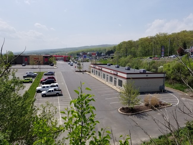
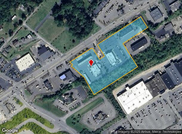
Property Record
610 Scranton Cdale Hwy, Scranton, PA 18519
NEARBY LISTINGS FOR SALE OR LEASE
Property Detail
610 Scranton Cdale Hwy
Scranton--Wilkes-Barre--Hazelton, PA
Merlyns Ventures Llc Minor Subdivision
11303030005
5.40A W-01 B-026 L-029 P-000
Taxexempt
Lackawanna
X
Pennsylvania
42069C0209D
29
2025
5.40 AC
2025
I-81 Corridor
111600
Philadelphia
DEMOGRAPHICS near 610 Scranton Cdale Hwy
1 Mile
3 Mile
5 Mile
2024 Total Population
897
47,802
127,147
2029 Population
882
47,296
125,853
Pop Growth 2024-2029
(1.67%)
(1.06%)
(1.02%)
Average Age
42
42
41
2024 Total Households
426
19,617
51,887
HH Growth 2024-2029
(1.64%)
(1.12%)
(1.05%)
Median Household Inc
$55,079
$58,985
$59,230
Avg Household Size
2.00
2.20
2.30
2024 Avg HH Vehicles
1.00
2.00
2.00
Median Home Value
$149,473
$159,877
$164,951
Median Year Built
1966
1949
1949
Nearby Places
Map Layers
Map Styles
 Street
 Aerial
- Restaurants
- Banks
- Shops
- Fitness
- Groceries
PUBLIC TRANSPORTATION
AIRPORT
Wilkes-Barre/Scranton International
DRIVE
WALK
Distance
Wilkes-Barre/Scranton International
23 min
15.5 mi
Freight Ports
Maher Terminal
DRIVE
WALK
Distance
Maher Terminal
146 min
116.5 mi
SALE & LEASE HISTORY
LISTING DATE
SALE/LEASE

Jul 30, 2018
For Lease
Nearby Properties
Address
Land Use
TOTAL SIZE
Lot Size
Zoning
Address
Land Use
TOTAL SIZE
Lot Size
Zoning
43.66 AC
Address
Land Use
TOTAL SIZE
Lot Size
Zoning
12.88 AC
Address
Land Use
TOTAL SIZE
Lot Size
Zoning
7.81 AC
Address
Land Use
TOTAL SIZE
Lot Size
Zoning
Address
Land Use
TOTAL SIZE
Lot Size
Zoning
43.52 AC
Address
Land Use
TOTAL SIZE
Lot Size
Zoning
25.62 AC
Address
Land Use
TOTAL SIZE
Lot Size
Zoning
Address
Land Use
TOTAL SIZE
Lot Size
Zoning
97.16 AC
Address
Land Use
TOTAL SIZE
Lot Size
Zoning
5.35 AC
Address
Land Use
TOTAL SIZE
Lot Size
Zoning
Address
Land Use
TOTAL SIZE
Lot Size
Zoning
28.89 AC
Address
Land Use
TOTAL SIZE
Lot Size
Zoning
3.12 AC
Address
Land Use
TOTAL SIZE
Lot Size
Zoning
Address
Land Use
TOTAL SIZE
Lot Size
Zoning
5.65 AC
Address
Land Use
TOTAL SIZE
Lot Size
Zoning
3.73 AC
Address
Land Use
TOTAL SIZE
Lot Size
Zoning
14.20 AC
Address
Land Use
TOTAL SIZE
Lot Size
Zoning
Address
Land Use
TOTAL SIZE
Lot Size
Zoning
43.10 AC
Address
Land Use
TOTAL SIZE
Lot Size
Zoning
1.87 AC
Address
Land Use
TOTAL SIZE
Lot Size
Zoning
7.04 AC
Address
Land Use
TOTAL SIZE
Lot Size
Zoning
12.30 AC
Address
Land Use
TOTAL SIZE
Lot Size
Zoning
3.34 AC
Address
Land Use
TOTAL SIZE
Lot Size
Zoning
17.15 AC
Address
Land Use
TOTAL SIZE
Lot Size
Zoning
Address
Land Use
TOTAL SIZE
Lot Size
Zoning
15.30 AC
Address
Land Use
TOTAL SIZE
Lot Size
Zoning
Address
Land Use
TOTAL SIZE
Lot Size
Zoning
Address
Land Use
TOTAL SIZE
Lot Size
Zoning
2.86 AC
Address
Land Use
TOTAL SIZE
Lot Size
Zoning
Address
Land Use
TOTAL SIZE
Lot Size
Zoning
25 AC
The World's #1 Commercial Real Estate Marketplace
Connect with us
© 2025 CoStar Group
The information above has been obtained from sources believed reliable. While we do not doubt its accuracy we have not verified it and make no guarantee, warranty or representation about it. It is your responsibility to independently confirm its accuracy and completeness. Any projections, opinions, assumptions, or estimates used are for example only and do not represent the current or future performance of the property. The value of this transaction to you depends on tax and other factors which should be evaluated by your tax, financial, and legal advisors. You and your advisors should conduct a careful, independent investigation of the property to determine to your satisfaction the suitability of the property for your needs.