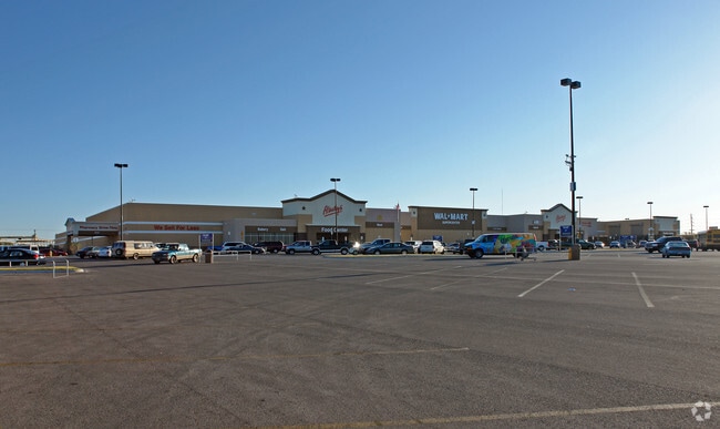
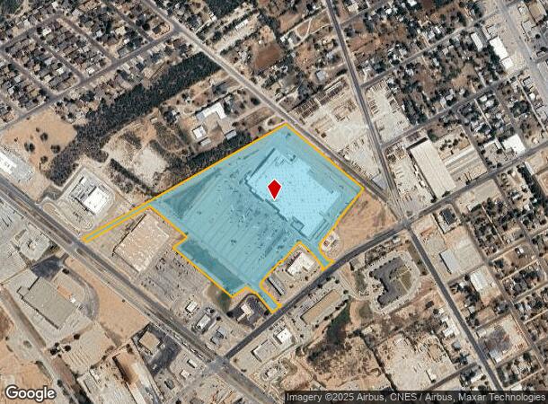
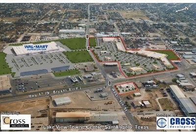
Property Record
610 W 29Th St, San Angelo, TX 76903
NEARBY LISTINGS FOR SALE OR LEASE
Property Detail
610 W 29Th St
San Angelo, TX
Wal-Mart North Add
25-47053-0001-003-00
ACRES: 25.939 LOT: 3R BLK: 1 SUBD: WAL-MART NORTH ADDITION SEC 2 BEING 25.938 ACRES FIRST REPLAT
Supermarket
Tom Green
X
Texas
48451C0480E
3r
2025
25.94 AC
2025
Texas West Area
000100
Other Market Areas
204,347 SF
DEMOGRAPHICS near 610 W 29Th St
1 Mile
3 Mile
5 Mile
2024 Total Population
6,230
39,027
80,444
2029 Population
6,269
38,938
80,014
Pop Growth 2024-2029
+ 0.63%
(0.23%)
(0.53%)
Average Age
36
38
37
2024 Total Households
2,395
15,031
31,101
HH Growth 2024-2029
+ 0.67%
(0.21%)
(0.57%)
Median Household Inc
$49,150
$49,340
$53,535
Avg Household Size
2.50
2.50
2.40
2024 Avg HH Vehicles
2.00
2.00
2.00
Median Home Value
$112,556
$117,366
$137,931
Median Year Built
1969
1961
1970
Nearby Places
Map Layers
Map Styles
 Street
 Aerial
- Restaurants
- Banks
- Shops
- Fitness
- Groceries
PUBLIC TRANSPORTATION
AIRPORT
San Angelo Regional/Mathis Field
DRIVE
WALK
Distance
San Angelo Regional/Mathis Field
22 min
12.5 mi
Freight Ports
Calhoun Port
DRIVE
WALK
Distance
Calhoun Port
401 min
362.0 mi
Nearby Properties
Address
Land Use
TOTAL SIZE
Lot Size
Zoning
Address
Land Use
TOTAL SIZE
Lot Size
Zoning
187,200 SF
4.01 AC
Address
Land Use
TOTAL SIZE
Lot Size
Zoning
53,850 SF
6.15 AC
Address
Land Use
TOTAL SIZE
Lot Size
Zoning
141,720 SF
7.56 AC
Address
Land Use
TOTAL SIZE
Lot Size
Zoning
81,000 SF
7.53 AC
Address
Land Use
TOTAL SIZE
Lot Size
Zoning
50,688 SF
2.11 AC
Address
Land Use
TOTAL SIZE
Lot Size
Zoning
44,550 SF
3.67 AC
Address
Land Use
TOTAL SIZE
Lot Size
Zoning
69,776 SF
3.59 AC
Address
Land Use
TOTAL SIZE
Lot Size
Zoning
39,960 SF
8.59 AC
Address
Land Use
TOTAL SIZE
Lot Size
Zoning
16,568 SF
2.18 AC
Address
Land Use
TOTAL SIZE
Lot Size
Zoning
73,884 SF
5.37 AC
Address
Land Use
TOTAL SIZE
Lot Size
Zoning
12,840 SF
1.99 AC
Address
Land Use
TOTAL SIZE
Lot Size
Zoning
70,000 SF
7.93 AC
Address
Land Use
TOTAL SIZE
Lot Size
Zoning
30,781 SF
18.21 AC
Address
Land Use
TOTAL SIZE
Lot Size
Zoning
Address
Land Use
TOTAL SIZE
Lot Size
Zoning
39,679 SF
5 AC
Address
Land Use
TOTAL SIZE
Lot Size
Zoning
32,000 SF
1.17 AC
Address
Land Use
TOTAL SIZE
Lot Size
Zoning
29,868 SF
46.28 AC
Address
Land Use
TOTAL SIZE
Lot Size
Zoning
93,000 SF
15.15 AC
Address
Land Use
TOTAL SIZE
Lot Size
Zoning
43,480 SF
5.08 AC
Address
Land Use
TOTAL SIZE
Lot Size
Zoning
50,880 SF
5.19 AC
Address
Land Use
TOTAL SIZE
Lot Size
Zoning
233,256 SF
18.55 AC
Address
Land Use
TOTAL SIZE
Lot Size
Zoning
34,647 SF
2.63 AC
Address
Land Use
TOTAL SIZE
Lot Size
Zoning
7,165 SF
5.56 AC
Address
Land Use
TOTAL SIZE
Lot Size
Zoning
25,170 SF
2.38 AC
Address
Land Use
TOTAL SIZE
Lot Size
Zoning
11,877 SF
1.70 AC
Address
Land Use
TOTAL SIZE
Lot Size
Zoning
36,278 SF
3.08 AC
Address
Land Use
TOTAL SIZE
Lot Size
Zoning
11,760 SF
3.34 AC
Address
Land Use
TOTAL SIZE
Lot Size
Zoning
56,060 SF
2.09 AC
Address
Land Use
TOTAL SIZE
Lot Size
Zoning
21,200 SF
5.94 AC
The World's #1 Commercial Real Estate Marketplace
Connect with us
© 2025 CoStar Group
The information above has been obtained from sources believed reliable. While we do not doubt its accuracy we have not verified it and make no guarantee, warranty or representation about it. It is your responsibility to independently confirm its accuracy and completeness. Any projections, opinions, assumptions, or estimates used are for example only and do not represent the current or future performance of the property. The value of this transaction to you depends on tax and other factors which should be evaluated by your tax, financial, and legal advisors. You and your advisors should conduct a careful, independent investigation of the property to determine to your satisfaction the suitability of the property for your needs.